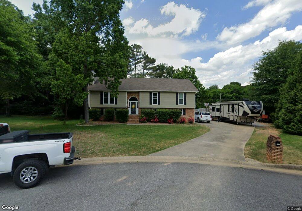
127 Mallard Pointe Dr Pelham, AL 35124
Estimated Value: $218,828 - $286,000
--
Bed
1
Bath
1,296
Sq Ft
$195/Sq Ft
Est. Value
About This Home
This home is located at 127 Mallard Pointe Dr, Pelham, AL 35124 and is currently estimated at $252,957, approximately $195 per square foot. 127 Mallard Pointe Dr is a home located in Shelby County with nearby schools including Pelham Oaks Elementary School, Pelham Park Middle School, and Pelham High School.
Ownership History
Date
Name
Owned For
Owner Type
Purchase Details
Closed on
Jul 17, 2018
Sold by
Staci R Howatt
Bought by
Todd Brent and Todd Brittany
Current Estimated Value
Home Financials for this Owner
Home Financials are based on the most recent Mortgage that was taken out on this home.
Original Mortgage
$225,150
Outstanding Balance
$195,256
Interest Rate
4.53%
Estimated Equity
$57,701
Purchase Details
Closed on
Jul 16, 2004
Sold by
Edmonds T Craig and Edmonds Peggy H
Bought by
Howatt Todd E and Howatt Staci R
Home Financials for this Owner
Home Financials are based on the most recent Mortgage that was taken out on this home.
Original Mortgage
$188,900
Interest Rate
6.24%
Mortgage Type
Purchase Money Mortgage
Create a Home Valuation Report for This Property
The Home Valuation Report is an in-depth analysis detailing your home's value as well as a comparison with similar homes in the area
Home Values in the Area
Average Home Value in this Area
Purchase History
| Date | Buyer | Sale Price | Title Company |
|---|---|---|---|
| Todd Brent | $237,000 | -- | |
| Howatt Todd E | $188,900 | -- |
Source: Public Records
Mortgage History
| Date | Status | Borrower | Loan Amount |
|---|---|---|---|
| Open | Todd Brent | $225,150 | |
| Closed | Todd Brent | -- | |
| Previous Owner | Howatt Todd E | $188,900 |
Source: Public Records
Tax History Compared to Growth
Tax History
| Year | Tax Paid | Tax Assessment Tax Assessment Total Assessment is a certain percentage of the fair market value that is determined by local assessors to be the total taxable value of land and additions on the property. | Land | Improvement |
|---|---|---|---|---|
| 2024 | $2,284 | $39,380 | $0 | $0 |
| 2023 | $1,946 | $33,560 | $0 | $0 |
| 2022 | $1,916 | $33,040 | $0 | $0 |
| 2021 | $1,695 | $29,220 | $0 | $0 |
| 2020 | $1,354 | $23,340 | $0 | $0 |
| 2019 | $1,315 | $22,680 | $0 | $0 |
| 2017 | $1,201 | $20,700 | $0 | $0 |
| 2015 | $1,160 | $20,000 | $0 | $0 |
| 2014 | $1,139 | $19,640 | $0 | $0 |
Source: Public Records
Map
Nearby Homes
- 54 Huntmaster Ln
- 113 Pintail Dr
- 119 Pintail Dr
- 32 Hunters Trace
- 110 Eagle Cove Dr
- 153 Silverleaf Dr
- 160 Hidden Creek Cove
- 157 Eagle Cove Dr
- 319 Hidden Creek Trail
- 107 Hidden Creek Cove
- 1058 Highway 72
- 133 Hidden Creek Cir
- 118 Hidden Creek Cir
- 192 Silverleaf Dr
- 405 Cambrian Ridge Dr
- 311 Coales Branch Cir
- 308 Coales Branch Cir
- 134 Hampton Lake Dr Unit 61 & 62
- 209 Calloway Ln
- 105 Hampton Ln Unit 13
- 127 Mallard Pointe Dr
- 117 Mallard Pointe Dr
- 119 Mallard Pointe Dr
- 112 Mallard Pointe Dr
- 121 Mallard Pointe Dr
- 115 Mallard Pointe Dr
- 130 Mallard Pointe Dr
- 113 Mallard Pointe Dr
- 123 Mallard Cir
- 110 Mallard Pointe Dr
- 111 Mallard Pointe Dr
- 132 Mallard Pointe Dr
- 129 Mallard Pointe Cir
- 125 Mallard Cir
- 109 Mallard Pointe Dr
- 127 Mallard Cir
- 127 Mallard Cir
- 131 Mallard Pointe Dr
- 133 Mallard Pointe Dr
- 142 Mallard Pointe Dr