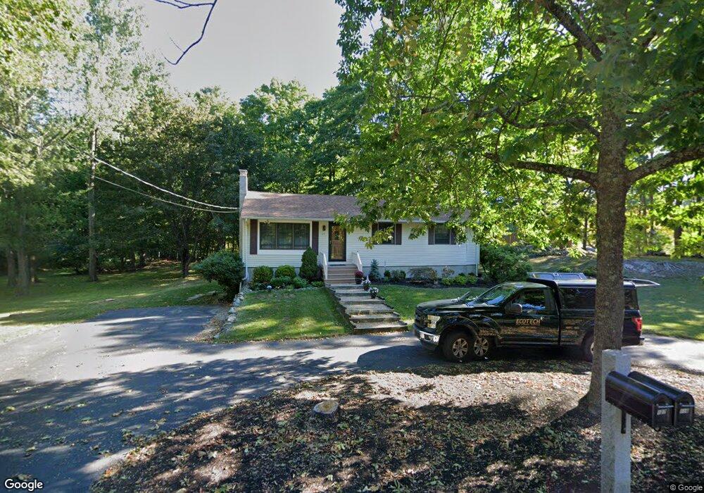
127 Walnut Ave North Hampton, NH 03862
Estimated Value: $539,000 - $602,000
3
Beds
2
Baths
1,056
Sq Ft
$532/Sq Ft
Est. Value
About This Home
This home is located at 127 Walnut Ave, North Hampton, NH 03862 and is currently estimated at $561,926, approximately $532 per square foot. 127 Walnut Ave is a home with nearby schools including North Hampton School, Winnacunnet High School, and Coastal Waters Chartered Public School (E).
Ownership History
Date
Name
Owned For
Owner Type
Purchase Details
Closed on
Dec 17, 2025
Sold by
Donohoe Linda S and Donohoe Barry M
Bought by
Syracusa Donohoe Ft and Donohoe
Current Estimated Value
Purchase Details
Closed on
May 26, 1989
Bought by
Donohoe Barry M and Syracusa Linda
Create a Home Valuation Report for This Property
The Home Valuation Report is an in-depth analysis detailing your home's value as well as a comparison with similar homes in the area
Home Values in the Area
Average Home Value in this Area
Purchase History
| Date | Buyer | Sale Price | Title Company |
|---|---|---|---|
| Syracusa Donohoe Ft | -- | -- | |
| Syracusa Donohoe Ft | -- | -- | |
| Donohoe Barry M | $131,500 | -- |
Source: Public Records
Mortgage History
| Date | Status | Borrower | Loan Amount |
|---|---|---|---|
| Previous Owner | Donohoe Barry M | $150,000 | |
| Previous Owner | Donohoe Barry M | $142,000 |
Source: Public Records
Tax History
| Year | Tax Paid | Tax Assessment Tax Assessment Total Assessment is a certain percentage of the fair market value that is determined by local assessors to be the total taxable value of land and additions on the property. | Land | Improvement |
|---|---|---|---|---|
| 2024 | $6,136 | $479,400 | $267,000 | $212,400 |
| 2023 | $5,969 | $479,400 | $267,000 | $212,400 |
| 2022 | $5,508 | $320,800 | $178,000 | $142,800 |
| 2021 | $5,316 | $320,800 | $178,000 | $142,800 |
| 2020 | $5,881 | $320,800 | $178,000 | $142,800 |
| 2019 | $2,364 | $320,800 | $178,000 | $142,800 |
| 2018 | $2,399 | $320,800 | $178,000 | $142,800 |
| 2017 | $5,513 | $254,700 | $148,300 | $106,400 |
| 2016 | $0 | $254,700 | $148,300 | $106,400 |
| 2015 | $4,452 | $254,700 | $148,300 | $106,400 |
| 2014 | $4,343 | $254,700 | $148,300 | $106,400 |
| 2013 | $4,266 | $254,700 | $148,300 | $106,400 |
Source: Public Records
Map
Nearby Homes
- 91 Lovering Rd
- 143 Walnut Ave
- Homesite 4 Windsong Place
- 8 Winterberry Ln
- Homesite 1 Windsong Place
- Homesite 2 Windsong Place
- 8 Montrose Dr
- 35 Montrose Dr
- 50 Thornhill Rd
- 49 Exeter Rd
- 131 Exeter Rd
- 135 Exeter Rd
- 120 Exeter Rd
- 21 Parkman Brook Ln
- 231 Post Rd
- 5 Sterling Hill Ln Unit 514
- 9 Garrett Dr
- 43 Hampton Rd
- 101 Robinhood Dr
- 801 Nottingham Dr
Your Personal Tour Guide
Ask me questions while you tour the home.