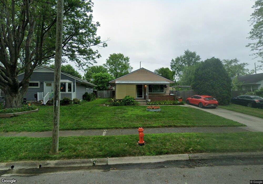
1270 Thurston Dr Columbus, OH 43227
Shady Lane NeighborhoodEstimated Value: $193,486 - $265,000
3
Beds
2
Baths
1,056
Sq Ft
$206/Sq Ft
Est. Value
About This Home
This home is located at 1270 Thurston Dr, Columbus, OH 43227 and is currently estimated at $217,622, approximately $206 per square foot. 1270 Thurston Dr is a home located in Franklin County with nearby schools including Shady Lane Elementary School, Sherwood Middle School, and Walnut Ridge High School.
Ownership History
Date
Name
Owned For
Owner Type
Purchase Details
Closed on
May 24, 2007
Sold by
Hatem Peter G and Hatem Carolyn D
Bought by
Henson Kathryn L
Current Estimated Value
Home Financials for this Owner
Home Financials are based on the most recent Mortgage that was taken out on this home.
Original Mortgage
$84,000
Outstanding Balance
$51,206
Interest Rate
6.21%
Mortgage Type
Purchase Money Mortgage
Estimated Equity
$166,416
Purchase Details
Closed on
Apr 28, 1993
Bought by
Hatem Peter G and Hatem Carolyn D
Purchase Details
Closed on
May 1, 1986
Create a Home Valuation Report for This Property
The Home Valuation Report is an in-depth analysis detailing your home's value as well as a comparison with similar homes in the area
Home Values in the Area
Average Home Value in this Area
Purchase History
| Date | Buyer | Sale Price | Title Company |
|---|---|---|---|
| Henson Kathryn L | $84,000 | Golden Titl | |
| Hatem Peter G | -- | -- | |
| -- | -- | -- |
Source: Public Records
Mortgage History
| Date | Status | Borrower | Loan Amount |
|---|---|---|---|
| Open | Henson Kathryn L | $84,000 |
Source: Public Records
Tax History Compared to Growth
Tax History
| Year | Tax Paid | Tax Assessment Tax Assessment Total Assessment is a certain percentage of the fair market value that is determined by local assessors to be the total taxable value of land and additions on the property. | Land | Improvement |
|---|---|---|---|---|
| 2024 | $2,584 | $57,580 | $14,950 | $42,630 |
| 2023 | $2,551 | $57,575 | $14,945 | $42,630 |
| 2022 | $1,472 | $28,390 | $5,600 | $22,790 |
| 2021 | $1,475 | $28,390 | $5,600 | $22,790 |
| 2020 | $1,477 | $28,390 | $5,600 | $22,790 |
| 2019 | $1,372 | $22,610 | $4,480 | $18,130 |
| 2018 | $1,312 | $22,610 | $4,480 | $18,130 |
| 2017 | $1,376 | $22,610 | $4,480 | $18,130 |
| 2016 | $1,382 | $20,860 | $4,410 | $16,450 |
| 2015 | $1,254 | $20,860 | $4,410 | $16,450 |
| 2014 | $1,257 | $20,860 | $4,410 | $16,450 |
| 2013 | $730 | $24,535 | $5,180 | $19,355 |
Source: Public Records
Map
Nearby Homes
- 1281 Maetzel Dr
- 4530 Amesbury Rd
- 4501 Amesbury Rd
- 4484 Grimsby Rd
- 4467 Grimsby Rd
- 4363 E Mound St
- 4295 Colby Ave
- 1068 Ross Rd
- 1571 Baxter Dr
- 1563 Genoa Place
- 4571 Aragon Ave
- 1291 Westphal Ave
- 1085 S Hamilton Rd
- 1543 S Hamilton Rd
- 4677 E Livingston Ave
- 1130 Little Plum Ln
- 1618 S Hamilton Rd
- 1607 Shady Lane Rd
- 4181 Colby Ave
- 1691 Shady Lane Rd
- 1276 Thurston Dr
- 1262 Thurston Dr
- 1263 Huntly Dr
- 1255 Huntly Dr
- 1284 Thurston Dr
- 1258 Thurston Dr
- 1271 Huntly Dr
- 1247 Huntly Dr
- 1275 Thurston Dr
- 1265 Thurston Dr
- 1277 Huntly Dr
- 1285 Thurston Dr
- 1239 Huntly Dr
- 1290 Thurston Dr
- 1254 Thurston Dr
- 1262 Maetzel Dr
- 1285 Huntly Dr
- 1274 Maetzel Dr
- 1233 Huntly Dr
- 1293 Thurston Dr