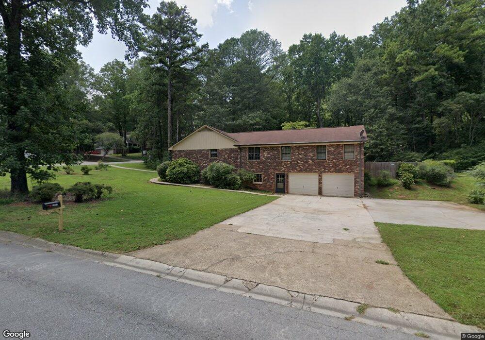
1271 Rockcrest Dr Marietta, GA 30062
Eastern Marietta NeighborhoodEstimated Value: $508,000 - $584,000
4
Beds
2
Baths
2,576
Sq Ft
$207/Sq Ft
Est. Value
About This Home
This home is located at 1271 Rockcrest Dr, Marietta, GA 30062 and is currently estimated at $532,424, approximately $206 per square foot. 1271 Rockcrest Dr is a home located in Cobb County with nearby schools including Kincaid Elementary School, Simpson Middle School, and Sprayberry High School.
Ownership History
Date
Name
Owned For
Owner Type
Purchase Details
Closed on
Oct 7, 2002
Sold by
Slaveikis David F and Slaveikis Patricia B
Bought by
Slaveikis David F and Slaveikis Patricia B
Current Estimated Value
Home Financials for this Owner
Home Financials are based on the most recent Mortgage that was taken out on this home.
Original Mortgage
$109,850
Interest Rate
6.21%
Mortgage Type
New Conventional
Purchase Details
Closed on
Sep 13, 2002
Sold by
Slaveikis Frank A and Slaveikis Genevieve T
Bought by
Slaveikis David F and Slaveikis Patricia B
Home Financials for this Owner
Home Financials are based on the most recent Mortgage that was taken out on this home.
Original Mortgage
$109,850
Interest Rate
6.21%
Mortgage Type
New Conventional
Purchase Details
Closed on
Apr 28, 2000
Sold by
Adkison Thomas H and Adkison Sharon J
Bought by
Slaveikis Frank A and Slaveikis Genevieve T
Home Financials for this Owner
Home Financials are based on the most recent Mortgage that was taken out on this home.
Original Mortgage
$105,000
Interest Rate
8.23%
Mortgage Type
New Conventional
Create a Home Valuation Report for This Property
The Home Valuation Report is an in-depth analysis detailing your home's value as well as a comparison with similar homes in the area
Home Values in the Area
Average Home Value in this Area
Purchase History
| Date | Buyer | Sale Price | Title Company |
|---|---|---|---|
| Slaveikis David F | -- | -- | |
| Slaveikis David F | -- | -- | |
| Slaveikis Frank A | $175,000 | -- |
Source: Public Records
Mortgage History
| Date | Status | Borrower | Loan Amount |
|---|---|---|---|
| Closed | Slaveikis David F | $109,850 | |
| Previous Owner | Slaveikis Frank A | $105,000 |
Source: Public Records
Tax History Compared to Growth
Tax History
| Year | Tax Paid | Tax Assessment Tax Assessment Total Assessment is a certain percentage of the fair market value that is determined by local assessors to be the total taxable value of land and additions on the property. | Land | Improvement |
|---|---|---|---|---|
| 2025 | $1,120 | $201,948 | $44,000 | $157,948 |
| 2024 | $1,169 | $216,924 | $36,000 | $180,924 |
| 2023 | $777 | $154,616 | $30,000 | $124,616 |
| 2022 | $942 | $141,112 | $30,000 | $111,112 |
| 2021 | $888 | $123,004 | $28,000 | $95,004 |
| 2020 | $850 | $110,316 | $26,000 | $84,316 |
| 2019 | $850 | $110,316 | $26,000 | $84,316 |
| 2018 | $808 | $96,028 | $22,000 | $74,028 |
| 2017 | $713 | $96,028 | $22,000 | $74,028 |
| 2016 | $686 | $86,624 | $22,000 | $64,624 |
| 2015 | $686 | $72,156 | $12,000 | $60,156 |
| 2014 | $1,877 | $72,156 | $0 | $0 |
Source: Public Records
Map
Nearby Homes
- 1237 Blackjack Ct
- 1511 Emerald Glen Dr
- 1391 Brentwood Ln
- 873 Edgewater Cir
- 1391 Cameron Glen Dr Unit 1
- 1769 Millview Dr
- 1580 Reids Ferry Way
- 943 Crestmanor Dr
- 939 Crestmanor Dr
- 931 Crestmanor Dr
- 935 Crestmanor Dr
- 923 Crestmanor Dr
- 1059 Grist Mill Dr
- 1071 Grist Mill Dr
- 1442 Glenover Cir
- 1255 Testarosa Way
- 1070 Grist Mill Dr
- 1080 Soaring Way NE
- 1941 Pine Bluff
- 1519 Evanston Ln
- 1553 Hillhaven Dr
- 1285 Rockcrest Dr
- 1270 Rockcrest Dr
- 1543 Hillhaven Dr
- 1280 Rockcrest Dr
- 1260 Rockcrest Dr
- 1562 Hillhaven Dr
- 1290 Rockcrest Dr
- 1250 Rockcrest Dr
- 1250 Rockcrest Dr Unit 1250
- 1533 Hillhaven Dr
- 1305 Rockcrest Dr
- 0 Hillhaven Dr Unit 8749622
- 1604 Allgood Rd
- 1542 Hillhaven Dr
- 1338 Rockcrest Dr
- 1240 Rockcrest Dr
- 1584 Allgood Rd Unit 1
- 1532 Hillhaven Dr
- 1523 Hillhaven Dr