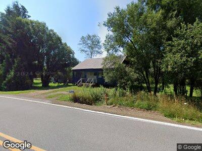
1271 State Route 44 N Coudersport, PA 16915
Estimated Value: $107,801 - $184,000
--
Bed
--
Bath
720
Sq Ft
$195/Sq Ft
Est. Value
About This Home
This home is located at 1271 State Route 44 N, Coudersport, PA 16915 and is currently estimated at $140,200, approximately $194 per square foot. 1271 State Route 44 N is a home located in Potter County with nearby schools including Coudersport Area Elementary School and Coudersport Area Junior/Senior High School.
Ownership History
Date
Name
Owned For
Owner Type
Purchase Details
Closed on
Apr 19, 2019
Sold by
Shunk Russell W
Bought by
Clark William and Clark Deborah
Current Estimated Value
Home Financials for this Owner
Home Financials are based on the most recent Mortgage that was taken out on this home.
Original Mortgage
$85,400
Interest Rate
4.4%
Mortgage Type
VA
Create a Home Valuation Report for This Property
The Home Valuation Report is an in-depth analysis detailing your home's value as well as a comparison with similar homes in the area
Home Values in the Area
Average Home Value in this Area
Purchase History
| Date | Buyer | Sale Price | Title Company |
|---|---|---|---|
| Clark William | $85,400 | Mortgage Connect Lp |
Source: Public Records
Mortgage History
| Date | Status | Borrower | Loan Amount |
|---|---|---|---|
| Open | Clark William H | $84,140 | |
| Closed | Clark William | $85,400 |
Source: Public Records
Tax History Compared to Growth
Tax History
| Year | Tax Paid | Tax Assessment Tax Assessment Total Assessment is a certain percentage of the fair market value that is determined by local assessors to be the total taxable value of land and additions on the property. | Land | Improvement |
|---|---|---|---|---|
| 2025 | $2,223 | $30,840 | $11,520 | $19,320 |
| 2024 | $2,115 | $30,840 | $11,520 | $19,320 |
| 2023 | $2,054 | $30,840 | $11,520 | $19,320 |
| 2022 | $2,007 | $30,840 | $11,520 | $19,320 |
| 2021 | $2,007 | $30,840 | $11,520 | $19,320 |
| 2020 | $2,007 | $30,840 | $11,520 | $19,320 |
| 2019 | $2,007 | $30,840 | $11,520 | $19,320 |
| 2018 | $1,961 | $30,840 | $11,520 | $19,320 |
| 2017 | -- | $30,840 | $11,520 | $19,320 |
| 2016 | $1,930 | $30,840 | $11,520 | $19,320 |
| 2015 | -- | $30,840 | $11,520 | $19,320 |
| 2012 | -- | $30,840 | $11,520 | $19,320 |
Source: Public Records
Map
Nearby Homes
- 228 Dry Run Rd
- 1571 State Route 44n
- 1571 State Route 44 N
- 1656 Pennsylvania 44
- 156 Hillcrest Dr
- 0 Sunshine Acres Ln
- 38 Tennessee Ave
- 00 Ridge Rd
- 443 S Branch Rd
- 153 Pinneo Hill Rd
- 252 School St
- 180 Tracy Brook Rd
- 176 Ford Hill
- 480 Bowers Rd
- 3057 Pennsylvania 44
- 89 Niles Hill Rd
- 2619 Eleven Mile Rd
- 423 Wb Fishing Creek Rd
- 2479 Route 44 S
- 423 W Branch Fishing Creek Rd
- 1271 State Route 44 N
- 1265 State Route 44 N
- 1260 State Route 44 N
- 1261 State Route 44 N
- 1278 State Route 44 N
- 1240 State Route 44 N
- 1278 Pennsylvania 44
- 1250 State Route 44 N
- 48 Schalard Ln
- 46 Schlard Ln
- 46 Schalard Ln
- 46 Schalard Ln
- 1333 State Route 44 N
- 84 Old Township Ln
- 11 Schalard Ln
- 4 Schalard Ln
- 1152 State Route 44 N
- 15 Dry Run Rd
- 1348 State Route 44 N
- 68 Old Township Ln