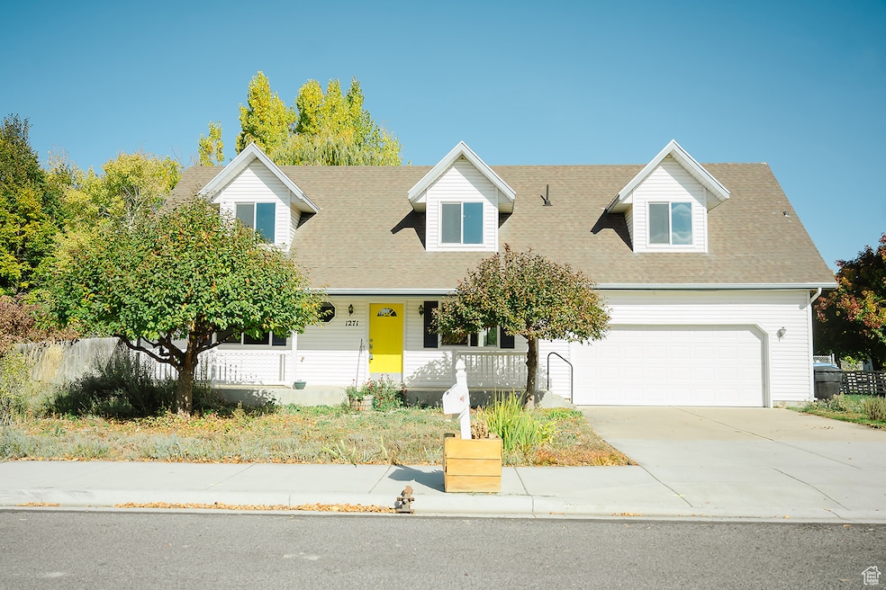
1271 W 350 S Logan, UT 84321
Woodruff NeighborhoodEstimated payment $2,919/month
Highlights
- Barn
- RV or Boat Parking
- 0.63 Acre Lot
- Horse Property
- Updated Kitchen
- Fruit Trees
About This Home
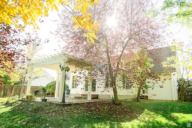
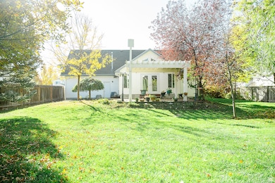
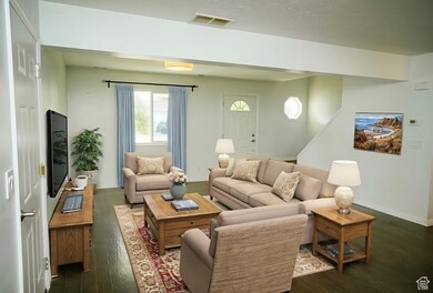
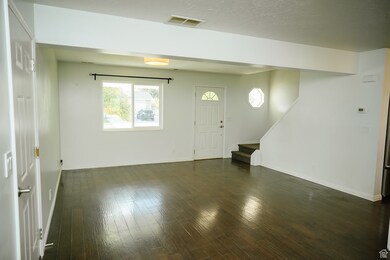
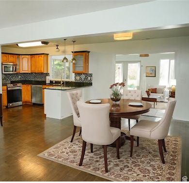
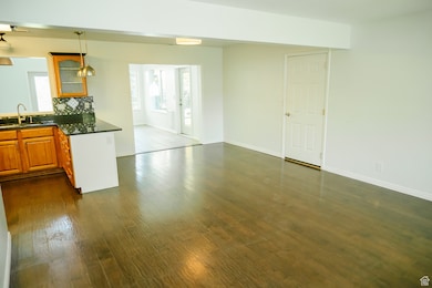
This beautiful home could be your own personal paradise! On a dead-end road a short walk to Logan's newest park and pickleball courts and close to everything! Year-round comfort: central air, six ceiling fans, argon-filled windows, new state-of-the-art Kohler walk-in jetted tub and shower on the first floor with a raised toilet, huge walk-in shower on the second with an endless closet, large efficient tankless water heater, new (2023) conduction range and Bosch dishwasher, granite countertops and stainless steel appliances and sink, spacious sun room with vaulted ceiling where you can relax and spend your time. Out back, a large, doubly-fenced .63 acre yard stretches out from the pergola, shaded by a dozen different kinds of trees. A shed close to the house, a huge barn at the far end, even a canal with water shares! Out front, beautiful crabapple trees, flowers, and a driveway that faces south and melts the snow quickly. Call to schedule a private showing today!
Home Details
Home Type
- Single Family
Est. Annual Taxes
- $1,818
Year Built
- Built in 1996
Lot Details
- 0.63 Acre Lot
- Lot Dimensions are 90.0x305.0x90.0
- Cul-De-Sac
- Partially Fenced Property
- Xeriscape Landscape
- Secluded Lot
- Sprinkler System
- Fruit Trees
- Mature Trees
- Property is zoned Single-Family
Parking
- 2 Car Garage
- RV or Boat Parking
Interior Spaces
- 2,211 Sq Ft Home
- 2-Story Property
- Vaulted Ceiling
- Ceiling Fan
- Double Pane Windows
- French Doors
- Great Room
- Mountain Views
Kitchen
- Updated Kitchen
- Gas Range
- Microwave
- Granite Countertops
- Disposal
- Instant Hot Water
Flooring
- Wood
- Carpet
- Tile
Bedrooms and Bathrooms
- 3 Bedrooms | 1 Main Level Bedroom
- 2 Full Bathrooms
- Hydromassage or Jetted Bathtub
Laundry
- Dryer
- Washer
Outdoor Features
- Horse Property
- Outbuilding
- Porch
Schools
- Woodruff Elementary School
- Mt Logan Middle School
- Logan High School
Farming
- Barn
- 1 Irrigated Acre
Utilities
- Forced Air Heating and Cooling System
- Natural Gas Connected
Community Details
- No Home Owners Association
- Equestrian Estates Subdivision
Listing and Financial Details
- Assessor Parcel Number 02-133-0314
Map
Home Values in the Area
Average Home Value in this Area
Tax History
| Year | Tax Paid | Tax Assessment Tax Assessment Total Assessment is a certain percentage of the fair market value that is determined by local assessors to be the total taxable value of land and additions on the property. | Land | Improvement |
|---|---|---|---|---|
| 2025 | $1,818 | $235,135 | $0 | $0 |
| 2024 | $187 | $234,085 | $0 | $0 |
| 2023 | $1,941 | $231,805 | $0 | $0 |
| 2022 | $1,714 | $191,105 | $0 | $0 |
| 2021 | $1,686 | $290,375 | $62,000 | $228,375 |
| 2020 | $1,654 | $256,431 | $62,000 | $194,431 |
| 2019 | $1,729 | $256,430 | $62,000 | $194,430 |
| 2018 | $1,706 | $231,070 | $62,000 | $169,070 |
| 2017 | $1,599 | $114,510 | $0 | $0 |
| 2016 | $1,658 | $114,510 | $0 | $0 |
| 2015 | $1,487 | $102,595 | $0 | $0 |
| 2014 | $1,344 | $102,595 | $0 | $0 |
| 2013 | -- | $102,595 | $0 | $0 |
Property History
| Date | Event | Price | List to Sale | Price per Sq Ft |
|---|---|---|---|---|
| 10/20/2025 10/20/25 | For Sale | $525,000 | -- | $237 / Sq Ft |
Purchase History
| Date | Type | Sale Price | Title Company |
|---|---|---|---|
| Quit Claim Deed | -- | None Available | |
| Warranty Deed | -- | American Secure Title Logan | |
| Interfamily Deed Transfer | -- | Servicelink | |
| Warranty Deed | -- | Cache Title Company Inc |
Mortgage History
| Date | Status | Loan Amount | Loan Type |
|---|---|---|---|
| Previous Owner | $189,900 | New Conventional | |
| Previous Owner | $91,267 | New Conventional |
Source: UtahRealEstate.com
MLS Number: 2118569
APN: 02-133-0314
Disclaimer: Certain information contained herein is derived from information provided by parties other than Homes.com. All information provided is deemed reliable, but is not guaranteed to be accurate and should be independently verified.
![]() IDX information is provided exclusively for consumers’ personal, non-commercial use, that it may not be used for any purpose other than to identify prospective properties consumers may be interested in purchasing, and that the data is deemed reliable but is not guaranteed accurate by the MLS. Licensor is only providing the MLS Content and not other sources of data provided in the Product.
IDX information is provided exclusively for consumers’ personal, non-commercial use, that it may not be used for any purpose other than to identify prospective properties consumers may be interested in purchasing, and that the data is deemed reliable but is not guaranteed accurate by the MLS. Licensor is only providing the MLS Content and not other sources of data provided in the Product.
Based on information from the Wasatch Front Regional Multiple Listing Service, Inc.. All data, including all measurements and calculations of area, is obtained from various sources and has not been, and will not be, verified by broker or the MLS. All information should be independently reviewed and verified for accuracy. Properties may or may not be listed by the office/agent presenting the information.
- 370 S 1200 W Unit 2
- 1230 W 240 S
- 1227 W 500 S Unit 151
- 1099 Three Pointe Ave
- 506 S 1225 W
- 518 S 1225 W
- 542 1225 W
- Hemlock Plan at Sugar Creek - Logan
- Eucalyptus Plan at Sugar Creek - Logan
- Blackberry Plan at Sugar Creek - Logan
- Magnolia Plan at Sugar Creek - Logan
- 542 S 1225 W Unit 116
- 548 S 1225 W Unit 115
- 1239 W 575 S Unit 152
- 1220 W 575 S
- 1177 130 S
- 248 Sunstone Ct
- 1615 Silver Canoe Way
- 1585 W Silver Canoe Way
- 524 Rivergate Dr
