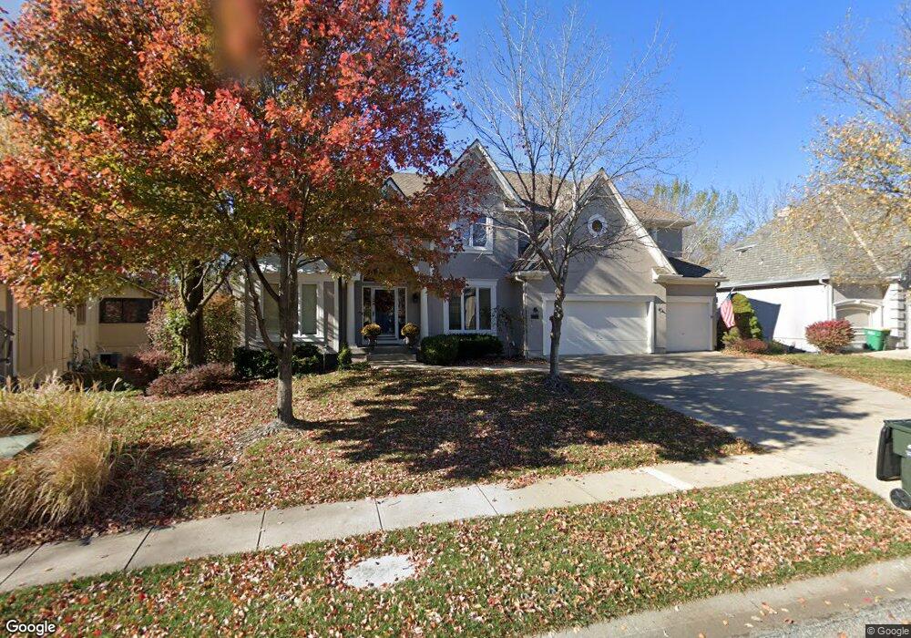
12716 Carter St Overland Park, KS 66213
Nottingham NeighborhoodEstimated Value: $630,000 - $664,000
4
Beds
6
Baths
3,444
Sq Ft
$189/Sq Ft
Est. Value
About This Home
This home is located at 12716 Carter St, Overland Park, KS 66213 and is currently estimated at $649,590, approximately $188 per square foot. 12716 Carter St is a home located in Johnson County with nearby schools including Cottonwood Point Elementary School, Oxford Middle, and Blue Valley Northwest High School.
Ownership History
Date
Name
Owned For
Owner Type
Purchase Details
Closed on
Sep 8, 2015
Sold by
Brown Kenton P and Brown Leslie K
Bought by
Brown Kenton P and Brown Leslie K
Current Estimated Value
Purchase Details
Closed on
Feb 5, 2001
Sold by
Monette Scott and Monette Karen
Bought by
Brown Kenton P and Brown Leslie K
Home Financials for this Owner
Home Financials are based on the most recent Mortgage that was taken out on this home.
Original Mortgage
$220,000
Interest Rate
6.25%
Create a Home Valuation Report for This Property
The Home Valuation Report is an in-depth analysis detailing your home's value as well as a comparison with similar homes in the area
Home Values in the Area
Average Home Value in this Area
Purchase History
| Date | Buyer | Sale Price | Title Company |
|---|---|---|---|
| Brown Kenton P | -- | None Available | |
| Brown Kenton P | -- | Chicago Title Insurance Co |
Source: Public Records
Mortgage History
| Date | Status | Borrower | Loan Amount |
|---|---|---|---|
| Previous Owner | Brown Kenton P | $220,000 |
Source: Public Records
Tax History Compared to Growth
Tax History
| Year | Tax Paid | Tax Assessment Tax Assessment Total Assessment is a certain percentage of the fair market value that is determined by local assessors to be the total taxable value of land and additions on the property. | Land | Improvement |
|---|---|---|---|---|
| 2024 | $7,175 | $69,760 | $13,858 | $55,902 |
| 2023 | $7,001 | $67,080 | $13,858 | $53,222 |
| 2022 | $6,214 | $58,513 | $13,858 | $44,655 |
| 2021 | $6,057 | $54,199 | $12,055 | $42,144 |
| 2020 | $6,016 | $53,463 | $9,639 | $43,824 |
| 2019 | $6,003 | $52,222 | $7,710 | $44,512 |
| 2018 | $5,759 | $49,105 | $7,710 | $41,395 |
| 2017 | $5,702 | $47,760 | $7,710 | $40,050 |
| 2016 | $5,379 | $45,023 | $7,710 | $37,313 |
| 2015 | $5,215 | $43,459 | $7,710 | $35,749 |
| 2013 | -- | $39,710 | $7,710 | $32,000 |
Source: Public Records
Map
Nearby Homes
- 12823 Connell Dr
- 12907 Connell Dr
- 12906 Wedd St
- 13416 W 178th St
- 13408 W 178th St
- 9117 W 125th Terrace
- 12510 Knox St
- 12506 Knox St
- 10416 W 131st St
- 13168 Carter St
- 8957 W 125th Terrace
- 9139 W 131st Place
- 13211 Farley St
- 10438 W 125th Terrace
- 13163 Kessler St
- 9608 W 132nd Terrace
- 12229 Carter St
- 12221 Farley St
- 9424 W 122nd St
- 9505 W 122nd St
- 12712 Carter St
- 12720 Carter St
- 12717 Carter St
- 12724 Carter St
- 9601 W 127th Terrace
- 12721 Carter St
- 9507 W 127th Terrace
- 9700 W 128th St
- 12728 Carter St
- 9605 W 127th Terrace
- 9701 W 128th St
- 12708 Grant St
- 9704 W 128th St
- 9503 W 127th Terrace
- 12710 Grant St
- 9609 W 127th Terrace
- 12712 Grant St
- 12732 Carter St
- 9630 W 128th Terrace
- 9626 W 128th Terrace