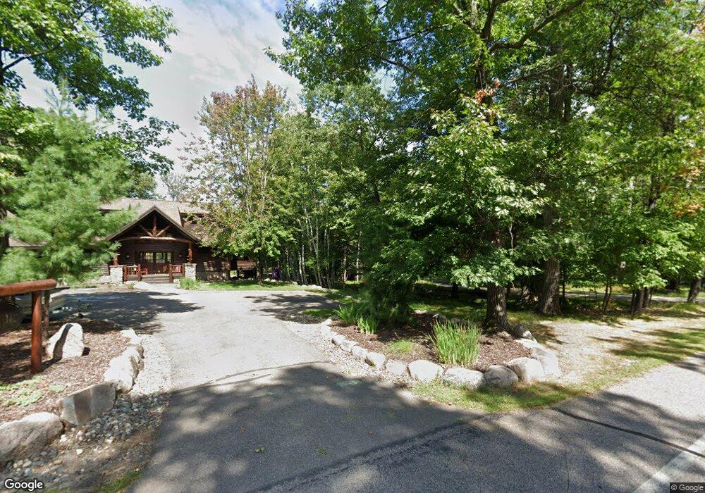
12722 Anchor Point Rd Crosslake, MN 56442
Estimated Value: $937,000 - $1,571,000
3
Beds
2
Baths
1,890
Sq Ft
$645/Sq Ft
Est. Value
About This Home
This home is located at 12722 Anchor Point Rd, Crosslake, MN 56442 and is currently estimated at $1,219,944, approximately $645 per square foot. 12722 Anchor Point Rd is a home with nearby schools including Eagle View Elementary School, Pequot Lakes Middle School, and Pequot Lakes Senior High School.
Ownership History
Date
Name
Owned For
Owner Type
Purchase Details
Closed on
Apr 1, 2024
Sold by
Trust Declaration and Young Jerald A
Bought by
Young Family Cabin Llc
Current Estimated Value
Purchase Details
Closed on
Apr 1, 2004
Bought by
Discher William and Discher Jill
Purchase Details
Closed on
Apr 1, 2003
Sold by
Young George and Young Kathryn
Bought by
Balmer Bothers Deve
Create a Home Valuation Report for This Property
The Home Valuation Report is an in-depth analysis detailing your home's value as well as a comparison with similar homes in the area
Home Values in the Area
Average Home Value in this Area
Purchase History
| Date | Buyer | Sale Price | Title Company |
|---|---|---|---|
| Young Family Cabin Llc | $500 | None Listed On Document | |
| Discher William | $935,000 | -- | |
| Balmer Bothers Deve | $250,000 | -- |
Source: Public Records
Tax History Compared to Growth
Tax History
| Year | Tax Paid | Tax Assessment Tax Assessment Total Assessment is a certain percentage of the fair market value that is determined by local assessors to be the total taxable value of land and additions on the property. | Land | Improvement |
|---|---|---|---|---|
| 2025 | $7,536 | $1,183,600 | $717,800 | $465,800 |
| 2024 | $7,536 | $1,113,100 | $671,600 | $441,500 |
| 2023 | $6,224 | $1,023,400 | $566,500 | $456,900 |
| 2022 | $5,206 | $928,400 | $482,300 | $446,100 |
| 2021 | $5,064 | $624,100 | $353,400 | $270,700 |
| 2020 | $5,054 | $566,300 | $323,400 | $242,900 |
| 2019 | $4,866 | $557,000 | $323,100 | $233,900 |
| 2018 | $4,696 | $541,100 | $323,100 | $218,000 |
| 2017 | $4,614 | $537,600 | $330,200 | $207,400 |
| 2016 | $4,454 | $513,000 | $317,500 | $195,500 |
| 2015 | $4,018 | $504,300 | $324,600 | $179,700 |
| 2014 | $1,626 | $419,700 | $249,100 | $170,600 |
Source: Public Records
Map
Nearby Homes
- 37639 Forest Lodge Rd
- 12125 Whitefish Ave
- 13380 Rush Harbor Dr
- 38738 Windsor Ave
- 38720 South Landing
- 13930 Log Landing
- 36943 Sundance Loop Unit 823
- 12048 Harbor Ln
- 36721 County Road 66
- 36587 Harbor Trail
- 36249 Johnie St
- 11690 Harbor Ln
- 11460 Lynn Boyd Way Unit Fraction 3
- 11959 Northgate Ln
- 37344 Deer Ridge Dr
- 10596 Wabigoniss Shores
- LOT 7 Retriever Rd
- 36168 Talon Trail
- L1B2 Wilderness Trail
- L5B2 Wilderness Trail
- 12726 Anchor Point Rd
- 12708 Anchor Point Rd
- 12732 Anchor Point Rd
- TBD Anchor Point Rd
- 12752 Anchor Point Rd
- 12695 Anchor Point Rd
- 12790 Anchor Point Rd
- 12664 Anchor Point Rd
- 12800 Anchor Point Rd
- 12661 Anchor Point Rd
- 12656 Anchor Point Rd
- 37810 Forest Lodge Rd
- 12651 Anchor Point Rd
- 12644 Anchor Point Rd
- 37808 Forest Lodge Rd
- 12807 Anchor Point Rd
- 37916 Forest Lodge Rd
- 12634 Anchor Point Rd
- 38011 Anchor Point Trail
- 38011 Anchor Point Ln