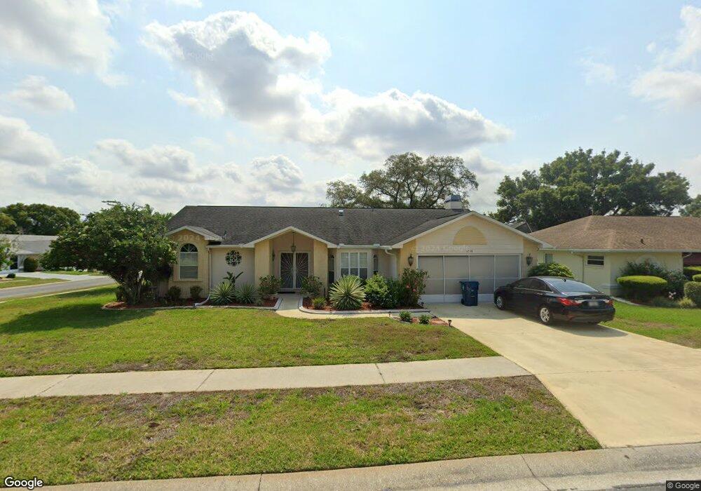
1276 Masada Ln Spring Hill, FL 34608
Estimated Value: $340,000 - $389,000
3
Beds
2
Baths
1,886
Sq Ft
$191/Sq Ft
Est. Value
About This Home
This home is located at 1276 Masada Ln, Spring Hill, FL 34608 and is currently estimated at $359,691, approximately $190 per square foot. 1276 Masada Ln is a home located in Hernando County with nearby schools including Suncoast Elementary School, Powell Middle School, and Frank W. Springstead High School.
Ownership History
Date
Name
Owned For
Owner Type
Purchase Details
Closed on
Sep 29, 2005
Sold by
Thorndale Sharon E and Thorndale Douglas E
Bought by
Browne Rochelle
Current Estimated Value
Purchase Details
Closed on
Apr 25, 2000
Sold by
Thorndale Douglas E and Thorndale Sharon E
Bought by
Thorndale Sharon E
Purchase Details
Closed on
Sep 21, 1999
Sold by
Spataro Michael and Spataro Susan M
Bought by
Thorndale Douglas D and Thorndale Sharon E
Home Financials for this Owner
Home Financials are based on the most recent Mortgage that was taken out on this home.
Original Mortgage
$91,120
Interest Rate
8.22%
Create a Home Valuation Report for This Property
The Home Valuation Report is an in-depth analysis detailing your home's value as well as a comparison with similar homes in the area
Home Values in the Area
Average Home Value in this Area
Purchase History
| Date | Buyer | Sale Price | Title Company |
|---|---|---|---|
| Browne Rochelle | $253,000 | Southeast Title Insurance Of | |
| Thorndale Sharon E | -- | -- | |
| Thorndale Douglas D | $113,900 | -- |
Source: Public Records
Mortgage History
| Date | Status | Borrower | Loan Amount |
|---|---|---|---|
| Previous Owner | Thorndale Douglas D | $91,120 |
Source: Public Records
Tax History
| Year | Tax Paid | Tax Assessment Tax Assessment Total Assessment is a certain percentage of the fair market value that is determined by local assessors to be the total taxable value of land and additions on the property. | Land | Improvement |
|---|---|---|---|---|
| 2025 | $2,063 | $132,817 | -- | -- |
| 2024 | $1,965 | $129,074 | -- | -- |
| 2023 | $1,965 | $125,315 | $0 | $0 |
| 2022 | $1,872 | $121,665 | $0 | $0 |
| 2021 | $1,864 | $118,121 | $0 | $0 |
| 2020 | $1,740 | $116,490 | $0 | $0 |
| 2019 | $1,735 | $113,871 | $0 | $0 |
| 2018 | $1,108 | $111,748 | $0 | $0 |
| 2017 | $1,422 | $109,450 | $0 | $0 |
| 2016 | $1,376 | $107,199 | $0 | $0 |
| 2015 | $1,383 | $106,454 | $0 | $0 |
| 2014 | $1,349 | $105,609 | $0 | $0 |
Source: Public Records
Map
Nearby Homes
- 1269 Masada Ln
- 1247 Venetia Dr
- 1250 Masada Ln
- 1289 Masada Ln
- 1319 Masada Ln
- 1238 Masada Ln
- 1285 Henry Ave
- 10464 Henderson St
- 11275 Linden Dr
- 1542 Overland Dr
- 1411 Mariner Blvd
- 1186 Muscovy Dr
- 11018 Audie Brook Dr
- 10421 Templewood Ct
- 1394 Escobar Ave
- 1113 El Portico Ln
- 11053 Via Santiago Ct
- 11008 Casa Grande Cir
- 10344 Henderson St
- 10443 Casa Grande Cir
Your Personal Tour Guide
Ask me questions while you tour the home.