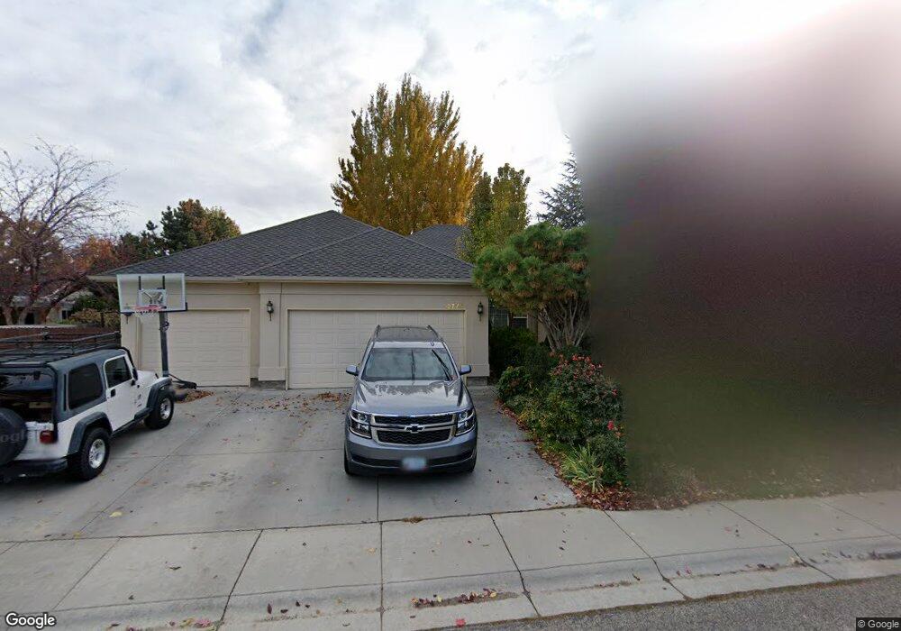
12775 W Silverbrook Ct Boise, ID 83713
West Boise NeighborhoodEstimated Value: $649,180 - $735,000
4
Beds
3
Baths
2,603
Sq Ft
$262/Sq Ft
Est. Value
About This Home
This home is located at 12775 W Silverbrook Ct, Boise, ID 83713 and is currently estimated at $680,795, approximately $261 per square foot. 12775 W Silverbrook Ct is a home located in Ada County with nearby schools including Joplin Elementary School, Lowell Scott Middle School, and Centennial High School.
Ownership History
Date
Name
Owned For
Owner Type
Purchase Details
Closed on
Apr 6, 2020
Sold by
Dechambeau John N and Dechambeau Kelly
Bought by
Dechambeau John N and Dechambeau Kelly
Current Estimated Value
Purchase Details
Closed on
Apr 4, 2012
Sold by
Dechambeau Jack R
Bought by
Dechambeau John N and Dechambeau Kelly D
Purchase Details
Closed on
Jun 3, 1999
Sold by
Royal Fork Restaurant Corp
Bought by
Dechambeau Jack R and Dechambeau Josephine
Create a Home Valuation Report for This Property
The Home Valuation Report is an in-depth analysis detailing your home's value as well as a comparison with similar homes in the area
Home Values in the Area
Average Home Value in this Area
Purchase History
| Date | Buyer | Sale Price | Title Company |
|---|---|---|---|
| Dechambeau John N | -- | None Available | |
| Dechambeau John N | -- | None Available | |
| Dechambeau John N | -- | None Available | |
| Dechambeau Jack R | -- | Alliance Title & Escrow Corp |
Source: Public Records
Tax History Compared to Growth
Tax History
| Year | Tax Paid | Tax Assessment Tax Assessment Total Assessment is a certain percentage of the fair market value that is determined by local assessors to be the total taxable value of land and additions on the property. | Land | Improvement |
|---|---|---|---|---|
| 2025 | $2,906 | $617,100 | -- | -- |
| 2024 | $2,917 | $564,500 | -- | -- |
| 2023 | $2,917 | $544,100 | $0 | $0 |
| 2022 | $3,336 | $619,100 | $0 | $0 |
| 2021 | $3,182 | $487,900 | $0 | $0 |
| 2020 | $2,918 | $389,500 | $0 | $0 |
| 2019 | $3,638 | $384,100 | $0 | $0 |
| 2018 | $3,446 | $342,600 | $0 | $0 |
| 2017 | $3,084 | $303,100 | $0 | $0 |
| 2016 | $3,157 | $297,600 | $0 | $0 |
| 2015 | $1,485 | $279,400 | $0 | $0 |
| 2012 | -- | $212,700 | $0 | $0 |
Source: Public Records
Map
Nearby Homes
- 4975 N Morninggale Way
- 5139 N Brookfield Place
- 12661 W Mercedes Ct
- 12360 W Avanti Dr
- 5360 N Noble Fir Ave
- 12773 W Engelmann Dr
- 12745 W Audi Ct
- 12421 W Engelmann Dr
- 12703 W Fig Ct
- 12253 W Norway St
- 5221 N Creswell Ave
- TBD Lot 3 W Garner Vines
- 5530 N Papago Ave
- TBD Lot 4 W Garner Vines
- 4991 N Blue Ash Way
- 5095 N Blue Ash Ave
- TBD Lot 8 W Garner Vines
- TBD Lot 2 W Garner Vines
- 3982 N Creswell St
- TBD Lot 5 W Garner Vines
- 12791 W Silverbrook Ct
- 5001 N Brookmeadow Way
- 12734 W Roseglen Ct
- 4989 N Brookmeadow Way
- 12798 W Silverbrook Ct
- 12809 W Silverbrook Ct
- 12737 W Roseglen Ct
- 12812 W Roseglen Ct
- 5075 N Brookmeadow Way
- 5002 N Brookmeadow Way
- 12830 W Silverbrook Ct
- 4988 N Brookmeadow Dr
- 12735 W Roseglen Ct
- 4988 N Brookmeadow Way
- 12811 W Roseglen Ct
- 5050 N Brookmeadow Way
- 12846 W Roseglen Ct
- 4917 N Brookmeadow Way
- 5103 N Brookmeadow Way
- 12847 W Silverbrook Ct