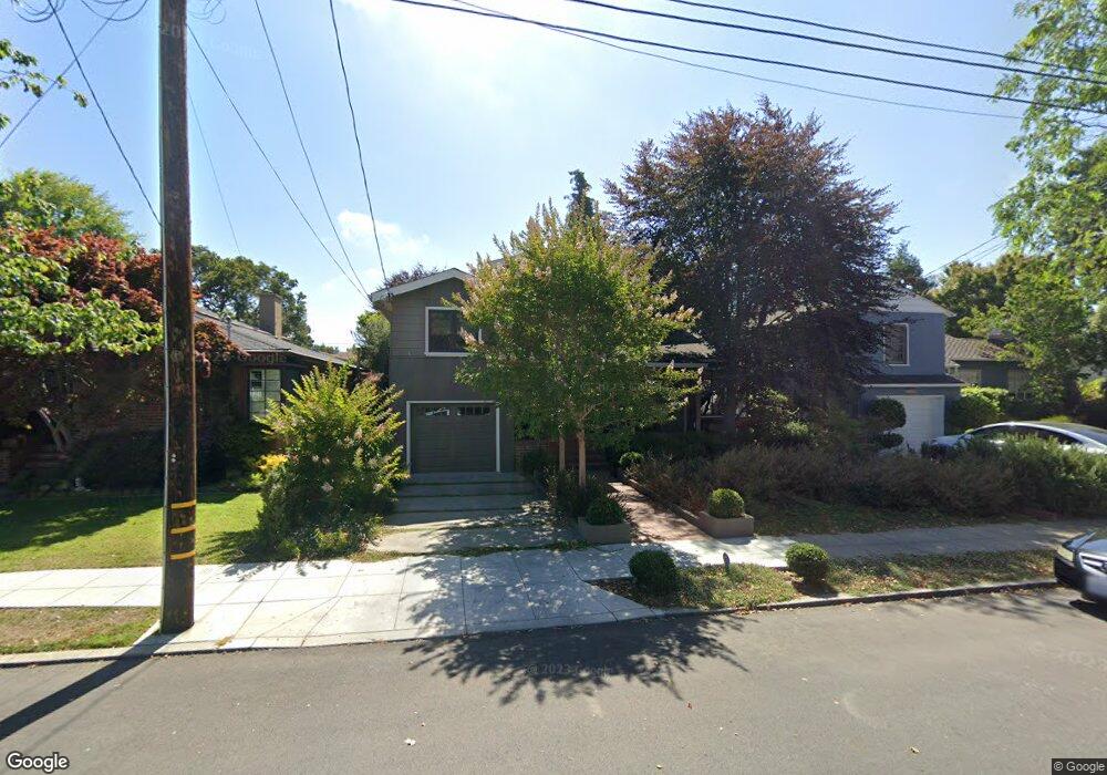
1278 Caroline St Alameda, CA 94501
South Shore NeighborhoodEstimated Value: $1,612,000 - $2,155,000
4
Beds
3
Baths
2,658
Sq Ft
$713/Sq Ft
Est. Value
About This Home
This home is located at 1278 Caroline St, Alameda, CA 94501 and is currently estimated at $1,896,102, approximately $713 per square foot. 1278 Caroline St is a home located in Alameda County with nearby schools including Franklin Elementary, Will C. Wood Middle School, and Encinal Junior/Senior High.
Ownership History
Date
Name
Owned For
Owner Type
Purchase Details
Closed on
Apr 13, 1998
Sold by
Wedgwood William D and Chaparteguy Jane E
Bought by
Hester Kevin P and Hester Amy D
Current Estimated Value
Home Financials for this Owner
Home Financials are based on the most recent Mortgage that was taken out on this home.
Original Mortgage
$238,000
Outstanding Balance
$45,496
Interest Rate
7.18%
Estimated Equity
$1,850,606
Create a Home Valuation Report for This Property
The Home Valuation Report is an in-depth analysis detailing your home's value as well as a comparison with similar homes in the area
Home Values in the Area
Average Home Value in this Area
Purchase History
| Date | Buyer | Sale Price | Title Company |
|---|---|---|---|
| Hester Kevin P | $298,000 | North American Title Co |
Source: Public Records
Mortgage History
| Date | Status | Borrower | Loan Amount |
|---|---|---|---|
| Open | Hester Kevin P | $238,000 |
Source: Public Records
Tax History Compared to Growth
Tax History
| Year | Tax Paid | Tax Assessment Tax Assessment Total Assessment is a certain percentage of the fair market value that is determined by local assessors to be the total taxable value of land and additions on the property. | Land | Improvement |
|---|---|---|---|---|
| 2025 | $10,791 | $669,848 | $167,650 | $509,198 |
| 2024 | $10,791 | $656,580 | $164,363 | $499,217 |
| 2023 | $10,408 | $650,570 | $161,141 | $489,429 |
| 2022 | $10,188 | $630,815 | $157,981 | $479,834 |
| 2021 | $9,956 | $618,310 | $154,884 | $470,426 |
| 2020 | $9,842 | $618,900 | $153,296 | $465,604 |
| 2019 | $9,016 | $606,768 | $150,291 | $456,477 |
| 2018 | $8,798 | $594,874 | $147,345 | $447,529 |
| 2017 | $8,415 | $583,213 | $144,456 | $438,757 |
| 2016 | $8,420 | $571,781 | $141,625 | $430,156 |
| 2015 | $8,390 | $563,193 | $139,497 | $423,696 |
| 2014 | $7,980 | $552,163 | $136,765 | $415,398 |
Source: Public Records
Map
Nearby Homes
- 901 San Antonio Ave
- 1220 9th St
- 1301 9th St
- 1059 Santa Clara Ave
- 1512 Mozart St
- 955 Shorepoint Ct Unit 110
- 955 Shorepoint Ct Unit 200
- 1203 Benton St
- 1523 Verdi St
- 950 Shorepoint Ct Unit 100
- 965 Shorepoint Ct
- 933 Shoreline Dr Unit 203
- 1001 Shoreline Dr Unit 301
- 1017 Lincoln Ave
- 1305 Webster St Unit C309
- 1305 Webster St Unit C102
- 404 Coral Reef Rd
- 1333 Webster St Unit A107
- 610 Grand St
- 1321 Webster St Unit D119
- 1276 Caroline St
- 1280 Caroline St
- 1284 Caroline St
- 1270 Caroline St
- 1251 Hawthorne St
- 1290 Caroline St
- 1247 Hawthorne St
- 1272 Caroline St
- 1253 Hawthorne St
- 1257 Hawthorne St
- 1277 Caroline St
- 1279 Caroline St
- 1266 Caroline St
- 1245 Hawthorne St
- 1259 Hawthorne St
- 1281 Caroline St
- 1275 Caroline St
- 1285 Caroline St
- 1276 Weber St
- 1020 San Antonio Ave