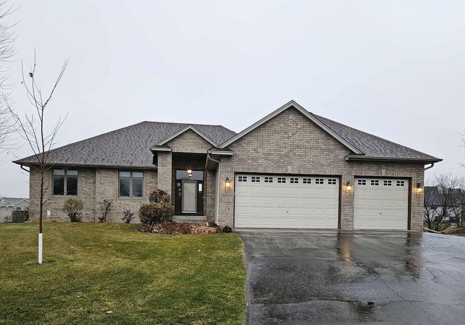
12796 Bluebird St NW Coon Rapids, MN 55448
Estimated payment $3,424/month
Highlights
- Family Room with Fireplace
- No HOA
- The kitchen features windows
- Mud Room
- Stainless Steel Appliances
- Cul-De-Sac
About This Home
Welcome to this beautifully maintained 5-bedroom, 4-bath home built in 2003 and nestled on a spacious, fenced-in lot in a quiet cul-de-sac. Enjoy an unbeatable location just steps from Prairie Oaks Park—one of Coon Rapids’ newest parks—featuring a large play area, paved walking loop, and a picnic shelter. This move-in-ready home offers a bright and inviting layout with 3 bedrooms on the main level, including a generous primary suite complete with a jetted tub, separate shower, and walk-in closet. The living room features a cozy fireplace, and the updated decking and patio (2023) make outdoor living a breeze. Downstairs, you’ll find a spacious family room with a second fireplace and a wet bar—perfect for entertaining. The piano stays! A flexible additional room in the lower level can serve as a 5th bedroom or a private office. A convenient mudroom in the basement leads to stairs to access the garage for everyday functionality. Additional highlights include panel doors throughout, a bonus room on the main level off the garage, and a 3-car garage providing plenty of storage. You also have peace of mind with the Roof being replaced in 2019. Sitting on nearly half an acre, this property offers both space and privacy while remaining close to parks, schools, and conveniences. A wonderful opportunity to own a well-cared-for home in a fantastic location—truly a must-see! Call me to schedule your private tour!
Open House Schedule
-
Saturday, November 29, 202511:00 am to 1:00 pm11/29/2025 11:00:00 AM +00:0011/29/2025 1:00:00 PM +00:00Add to Calendar
Home Details
Home Type
- Single Family
Est. Annual Taxes
- $4,974
Year Built
- Built in 2003
Lot Details
- 0.45 Acre Lot
- Lot Dimensions are 48x147x110x113x142
- Cul-De-Sac
- Chain Link Fence
- Irregular Lot
- Few Trees
Parking
- 3 Car Attached Garage
- Garage Door Opener
Home Design
- Metal Siding
- Vinyl Siding
Interior Spaces
- 1-Story Property
- Stone Fireplace
- Brick Fireplace
- Gas Fireplace
- Mud Room
- Family Room with Fireplace
- 2 Fireplaces
- Living Room with Fireplace
- Dining Room
Kitchen
- Range
- Microwave
- Dishwasher
- Stainless Steel Appliances
- Disposal
- The kitchen features windows
Bedrooms and Bathrooms
- 5 Bedrooms
Laundry
- Dryer
- Washer
Finished Basement
- Walk-Out Basement
- Basement Fills Entire Space Under The House
- Drain
- Natural lighting in basement
Eco-Friendly Details
- Air Exchanger
Utilities
- Forced Air Heating and Cooling System
- Vented Exhaust Fan
- 200+ Amp Service
Community Details
- No Home Owners Association
Listing and Financial Details
- Assessor Parcel Number 023124320016
Map
Home Values in the Area
Average Home Value in this Area
Tax History
| Year | Tax Paid | Tax Assessment Tax Assessment Total Assessment is a certain percentage of the fair market value that is determined by local assessors to be the total taxable value of land and additions on the property. | Land | Improvement |
|---|---|---|---|---|
| 2025 | $4,998 | $492,000 | $132,900 | $359,100 |
| 2024 | $4,998 | $464,800 | $127,100 | $337,700 |
| 2023 | $4,824 | $528,100 | $121,300 | $406,800 |
| 2022 | $4,871 | $486,600 | $121,300 | $365,300 |
| 2021 | $4,585 | $432,900 | $120,800 | $312,100 |
| 2020 | $4,794 | $398,300 | $102,700 | $295,600 |
| 2019 | $4,741 | $398,300 | $90,600 | $307,700 |
| 2015 | -- | $325,100 | $55,700 | $269,400 |
| 2014 | -- | $300,600 | $61,700 | $238,900 |
Purchase History
| Date | Type | Sale Price | Title Company |
|---|---|---|---|
| Quit Claim Deed | -- | All American Title Company | |
| Quit Claim Deed | -- | Alliance Title Llc | |
| Sheriffs Deed | $390,072 | None Available | |
| Warranty Deed | $207,700 | -- |
Mortgage History
| Date | Status | Loan Amount | Loan Type |
|---|---|---|---|
| Previous Owner | $313,222 | FHA |
Source: NorthstarMLS
MLS Number: 6816181
APN: 02-31-24-32-0016
Disclaimer: Certain information contained herein is derived from information provided by parties other than Homes.com. All information provided is deemed reliable, but is not guaranteed to be accurate and should be independently verified.
![]() Based on information submitted to the MLS GRID. All data is obtained from various sources and may not have been verified by broker or MLS GRID. Supplied Open House Information is subject to change without notice. All information should be independently reviewed and verified for accuracy. Properties may or may not be listed by the office/agent presenting the information. Some IDX listings have been excluded from this website.
Based on information submitted to the MLS GRID. All data is obtained from various sources and may not have been verified by broker or MLS GRID. Supplied Open House Information is subject to change without notice. All information should be independently reviewed and verified for accuracy. Properties may or may not be listed by the office/agent presenting the information. Some IDX listings have been excluded from this website.
The Digital Millennium Copyright Act of 1998, 17 U.S.C. § 512 (the “DMCA”) provides recourse for copyright owners who believe that material appearing on the Internet infringes their rights under U.S. copyright law. If you believe in good faith that any content or material made available in connection with our website or services infringes your copyright, you (or your agent) may send us a notice requesting that the content or material be removed, or access to it blocked.
Notices must be sent in writing by email to DMCAnotice@MLSGrid.com.
The DMCA requires that your notice of alleged copyright infringement include the following information:
(1) description of the copyrighted work that is the subject of claimed infringement;
(2) description of the alleged infringing content and information sufficient to permit us to locate the content;
(3) contact information for you, including your address, telephone number and email address;
(4) a statement by you that you have a good faith belief that the content in the manner complained of is not authorized by the copyright owner, or its agent, or by the operation of any law;
(5) a statement by you, signed under penalty of perjury, that the information in the notification is accurate and that you have the authority to enforce the copyrights that are claimed to be infringed; and
(6) a physical or electronic signature of the copyright owner or a person authorized to act on the copyright owner’s behalf. Failure to include all of the above information may result in the delay of the processing of your complaint.
- 1520 129th Ave NW
- 1450 126th Ln NW
- 12806 Yellow Pine St NW
- 1234 128th Cir NW
- 1593 126th Ln NW
- 12554 Grouse St NW
- 12759 Ibis St NW
- 13078 Crane St NW
- 12720 Ibis St NW
- 12463 Drake St NW
- 13182 Crane St NW
- 1687 131st Ln NW
- 1920 128th Ave NW
- 1879 128th Ave NW
- 12488 Unity St NW
- 1930 127th Cir NW
- 12365 Jay St NW
- 12459 Sycamore St NW
- 1776 133rd Ave NW
- 12888 Nightingale St NW
- 1770 121st Ave NW
- 11931 Crane St NW
- 12233 Quinn St NW
- 12272 Quinn St NW
- 11907 Wintergreen St NW
- 11756 Xeon St NW
- 11307 Robinson Dr NW
- 11360 Robinson Dr NW
- 11501 Raven St NW
- 2521 138th Ave NW
- 11205-11255 Hanson Blvd
- 370 125th Ave NE
- 14371 Raven St NW
- 43 115th Ln NE Unit 487
- 3393 Northdale Blvd NW
- 3130 Northdale Blvd
- 3120-3140 Northdale Blvd
- 117 116th Ave NE Unit 420
- 1018 108th Ln NW
- 10673 Grouse St NW
