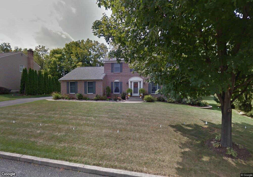
128 Robert Dr Allentown, PA 18104
Upper Macungie Township NeighborhoodEstimated Value: $514,000 - $581,000
3
Beds
3
Baths
2,098
Sq Ft
$260/Sq Ft
Est. Value
About This Home
This home is located at 128 Robert Dr, Allentown, PA 18104 and is currently estimated at $546,000, approximately $260 per square foot. 128 Robert Dr is a home located in Lehigh County with nearby schools including Cetronia Elementary School, Springhouse Middle School, and Parkland High School.
Ownership History
Date
Name
Owned For
Owner Type
Purchase Details
Closed on
Jul 31, 2008
Sold by
Bieber Ray
Bought by
Magee Keith A
Current Estimated Value
Home Financials for this Owner
Home Financials are based on the most recent Mortgage that was taken out on this home.
Original Mortgage
$100,000
Outstanding Balance
$66,146
Interest Rate
6.49%
Mortgage Type
New Conventional
Estimated Equity
$479,854
Purchase Details
Closed on
Jan 29, 1993
Sold by
Lehigh Valley Land Association Inc
Bought by
Bieber Ray and Bieber Ruth
Purchase Details
Closed on
Jun 29, 1988
Bought by
Lehigh Valley Land Association Inc
Create a Home Valuation Report for This Property
The Home Valuation Report is an in-depth analysis detailing your home's value as well as a comparison with similar homes in the area
Home Values in the Area
Average Home Value in this Area
Purchase History
| Date | Buyer | Sale Price | Title Company |
|---|---|---|---|
| Magee Keith A | $300,000 | -- | |
| Bieber Ray | $45,000 | -- | |
| Lehigh Valley Land Association Inc | $1,522,500 | -- |
Source: Public Records
Mortgage History
| Date | Status | Borrower | Loan Amount |
|---|---|---|---|
| Open | Magee Keith A | $100,000 |
Source: Public Records
Tax History Compared to Growth
Tax History
| Year | Tax Paid | Tax Assessment Tax Assessment Total Assessment is a certain percentage of the fair market value that is determined by local assessors to be the total taxable value of land and additions on the property. | Land | Improvement |
|---|---|---|---|---|
| 2025 | $5,672 | $262,100 | $42,900 | $219,200 |
| 2024 | $5,457 | $262,100 | $42,900 | $219,200 |
| 2023 | $5,326 | $262,100 | $42,900 | $219,200 |
| 2022 | $5,302 | $262,100 | $219,200 | $42,900 |
| 2021 | $5,302 | $262,100 | $42,900 | $219,200 |
| 2020 | $5,302 | $262,100 | $42,900 | $219,200 |
| 2019 | $5,190 | $262,100 | $42,900 | $219,200 |
| 2018 | $5,087 | $262,100 | $42,900 | $219,200 |
| 2017 | $5,014 | $262,100 | $42,900 | $219,200 |
| 2016 | -- | $262,100 | $42,900 | $219,200 |
| 2015 | -- | $262,100 | $42,900 | $219,200 |
| 2014 | -- | $262,100 | $42,900 | $219,200 |
Source: Public Records
Map
Nearby Homes
- 6126 Palomino Dr
- 5137 Schantz Rd Unit The Jackson
- 5137 Schantz Rd Unit The Kennedy
- 5137 Schantz Rd Unit The Roosevelt
- 5137 Schantz Rd Unit The Madison
- 5137 Schantz Rd Unit The Monroe
- 5137 Schantz Rd Unit The Jefferson
- 226 Snapdragon Way
- Stargrass Plan at Hidden Meadows - Fountain View at Hidden Meadows
- 495 Gray Feather Way
- 2021 Hickory Ln
- 247 Milkweed Dr
- 258 Milkweed Dr
- 439 Gray Feather Way
- 560 Gray Feather Way
- 629 Fountain View Cir
- 625 Fountain View Cir
- 625 Fountain View Cir Unit 10
- 5619 Stonecroft Ln
- 6401 Fir Rd