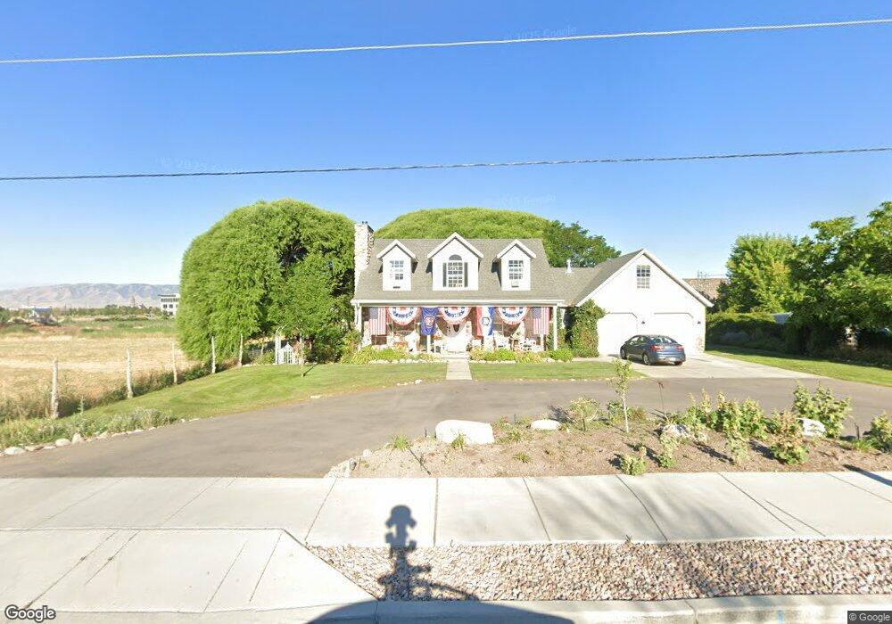
128 S 1300 W Pleasant Grove, UT 84062
Estimated Value: $594,000 - $762,000
3
Beds
2
Baths
2,523
Sq Ft
$261/Sq Ft
Est. Value
About This Home
This home is located at 128 S 1300 W, Pleasant Grove, UT 84062 and is currently estimated at $657,670, approximately $260 per square foot. 128 S 1300 W is a home with nearby schools including Mount Mahogany School, Pleasant Grove Junior High School, and Pleasant Grove High School.
Ownership History
Date
Name
Owned For
Owner Type
Purchase Details
Closed on
Oct 26, 2021
Sold by
Pleasant Grove City Corporation
Bought by
Pray Joy Living Revocable Trust
Current Estimated Value
Purchase Details
Closed on
Oct 14, 2021
Sold by
Proctor Joy R and Pray Joy Living Revocable Trus
Bought by
Proctor Jason R and Proctor Courtney L
Purchase Details
Closed on
Oct 25, 2007
Sold by
Proctor R Ray and Proctor Joy R
Bought by
Proctor R Ray and Proctor Joy R
Purchase Details
Closed on
Sep 24, 2003
Sold by
Long Richard C and Long Barbara
Bought by
Proctor R Ray and Proctor Joy R
Purchase Details
Closed on
Sep 22, 2003
Sold by
Proctor Jason Robinson and Proctor Courtney Long
Bought by
Long Richard C and Long Barbara
Create a Home Valuation Report for This Property
The Home Valuation Report is an in-depth analysis detailing your home's value as well as a comparison with similar homes in the area
Home Values in the Area
Average Home Value in this Area
Purchase History
| Date | Buyer | Sale Price | Title Company |
|---|---|---|---|
| Pray Joy Living Revocable Trust | -- | None Listed On Document | |
| Proctor Jason R | -- | Metro National Title Assc | |
| Proctor R Ray | -- | None Available | |
| Proctor R Ray | -- | Fidelity Land & Title | |
| Long Richard C | -- | Fidelity Land & Title |
Source: Public Records
Tax History Compared to Growth
Tax History
| Year | Tax Paid | Tax Assessment Tax Assessment Total Assessment is a certain percentage of the fair market value that is determined by local assessors to be the total taxable value of land and additions on the property. | Land | Improvement |
|---|---|---|---|---|
| 2025 | $2,749 | $331,705 | $275,200 | $327,900 |
| 2024 | $2,748 | $320,760 | $0 | $0 |
| 2023 | $2,748 | $335,720 | $0 | $0 |
| 2022 | $2,761 | $335,665 | $0 | $0 |
| 2021 | $2,300 | $425,700 | $172,800 | $252,900 |
| 2020 | $2,117 | $384,200 | $154,300 | $229,900 |
| 2019 | $1,842 | $345,600 | $145,700 | $199,900 |
| 2018 | $1,704 | $302,400 | $128,600 | $173,800 |
| 2017 | $1,578 | $149,105 | $0 | $0 |
| 2016 | $1,503 | $137,115 | $0 | $0 |
| 2015 | $1,560 | $134,750 | $0 | $0 |
| 2014 | -- | $134,750 | $0 | $0 |
Source: Public Records
Map
Nearby Homes
- 1267 W 20 S
- 1406 W 50 N
- 1512 W 50 N
- 1559 W 50 N
- 1429 W 110 N
- 1249 W Cambria Dr Unit 101
- 150 N 1300 W
- 1542 W 110 N
- 123 N Romney Ln Unit 103
- 1584 W 110 N
- 128 S 1700 W Unit 12
- The Hastings Plan at Tayside Farm - Townhome
- The Henley A Plan at Tayside Farm - Single Family Home
- The Denton Plan at Tayside Farm - Townhome
- The Henley B Plan at Tayside Farm - Single Family Home
- 1775 W 120 S Unit 54
- 1795 W 120 S Unit 52
- 1593 W 220 N
- 289 S 1000 W Unit 203
- 317 S 1000 W Unit 104