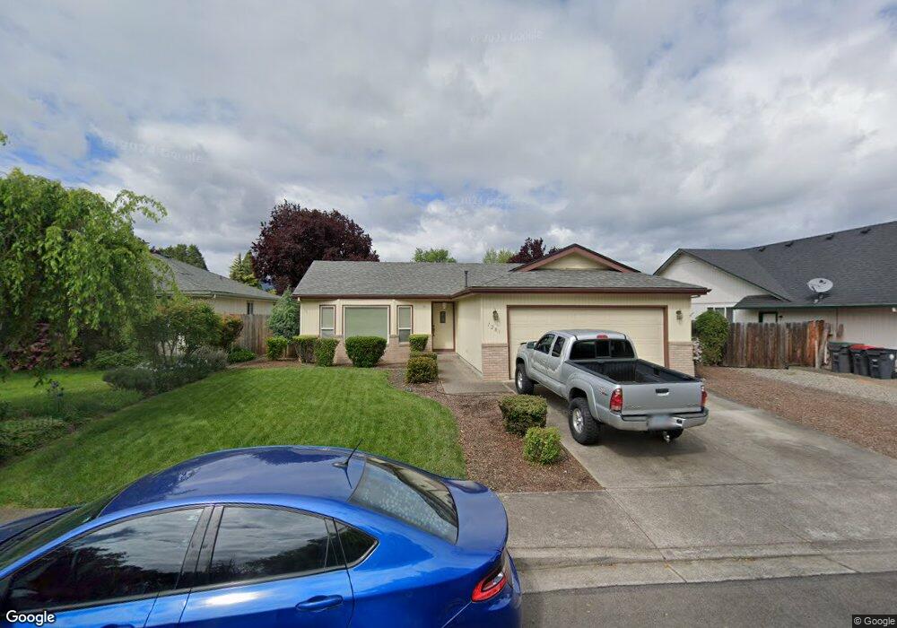
1281 Heather Ln Central Point, OR 97502
Estimated Value: $353,499 - $383,000
3
Beds
2
Baths
1,296
Sq Ft
$285/Sq Ft
Est. Value
About This Home
This home is located at 1281 Heather Ln, Central Point, OR 97502 and is currently estimated at $368,875, approximately $284 per square foot. 1281 Heather Ln is a home located in Jackson County with nearby schools including Howard Elementary School, McLoughlin Middle School, and North Medford High School.
Ownership History
Date
Name
Owned For
Owner Type
Purchase Details
Closed on
Nov 10, 1999
Sold by
Rattner Burce M and Rattner Colette G
Bought by
Thornton Richard H and Richard H Thornton Family Trus
Current Estimated Value
Purchase Details
Closed on
Mar 23, 1998
Sold by
Dunn Robert W
Bought by
Pattner Bruce M and Rattner Colette G
Home Financials for this Owner
Home Financials are based on the most recent Mortgage that was taken out on this home.
Original Mortgage
$91,200
Interest Rate
7.06%
Create a Home Valuation Report for This Property
The Home Valuation Report is an in-depth analysis detailing your home's value as well as a comparison with similar homes in the area
Home Values in the Area
Average Home Value in this Area
Purchase History
| Date | Buyer | Sale Price | Title Company |
|---|---|---|---|
| Thornton Richard H | $123,000 | Key Title Company | |
| Pattner Bruce M | $114,000 | Key Title Company |
Source: Public Records
Mortgage History
| Date | Status | Borrower | Loan Amount |
|---|---|---|---|
| Previous Owner | Pattner Bruce M | $91,200 |
Source: Public Records
Tax History Compared to Growth
Tax History
| Year | Tax Paid | Tax Assessment Tax Assessment Total Assessment is a certain percentage of the fair market value that is determined by local assessors to be the total taxable value of land and additions on the property. | Land | Improvement |
|---|---|---|---|---|
| 2025 | $3,337 | $199,490 | $72,470 | $127,020 |
| 2024 | $3,337 | $193,680 | $70,360 | $123,320 |
| 2023 | $3,236 | $188,040 | $68,310 | $119,730 |
| 2022 | $3,155 | $188,040 | $68,310 | $119,730 |
| 2021 | $3,072 | $182,570 | $66,320 | $116,250 |
| 2020 | $2,995 | $177,260 | $64,390 | $112,870 |
| 2019 | $2,921 | $167,090 | $60,690 | $106,400 |
| 2018 | $2,845 | $162,230 | $58,920 | $103,310 |
| 2017 | $2,789 | $162,230 | $58,920 | $103,310 |
| 2016 | $2,729 | $152,930 | $55,530 | $97,400 |
| 2015 | $2,623 | $152,930 | $55,530 | $97,400 |
| 2014 | $2,567 | $144,160 | $52,340 | $91,820 |
Source: Public Records
Map
Nearby Homes
- 881 Westrop Dr
- 3358 Bursell Rd
- 3364 Bursell Rd
- 745 Herman Ave
- 1065 Edwina Ave
- 3496 Edella St
- 659 Herman Ave
- 921 Pittview Ave
- 2825 Duell Ave
- 3600 N Pacific Hwy
- 851 Juanita Way
- 1017 Fairfield Ave
- 3119 Merriman Rd
- 571 Briarwood Dr
- 887 Silver Fox Dr
- 1025 Fairfield Ave
- 2711 Elliott Ave
- 1060 Hopkins Rd
- 928 Brandi Way
- 2825 Howard Ave
- 1301 Heather Ln
- 1271 Heather Ln
- 1292 Greentree Way
- 11012 Heather Ln
- 1272 Greentree Way
- 1261 Heather Ln
- 1322 Greentree Way
- 862 Westrop Dr
- 1312 Heather Ln
- 1252 Greentree Way
- 1251 Heather Ln
- 1341 Heather Ln
- 1342 Greentree Way
- 866 Westrop Dr
- 861 Westrop Dr
- 1324 Heather Ln
- 1231 Heather Ln
- 1361 Heather Ln
- 1362 Heather Ln