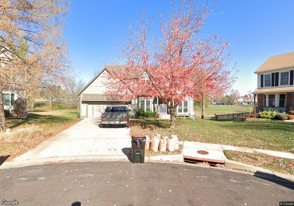
12810 Perry St Overland Park, KS 66213
Nottingham NeighborhoodEstimated Value: $514,000 - $571,000
4
Beds
4
Baths
2,744
Sq Ft
$197/Sq Ft
Est. Value
About This Home
This home is located at 12810 Perry St, Overland Park, KS 66213 and is currently estimated at $539,374, approximately $196 per square foot. 12810 Perry St is a home located in Johnson County with nearby schools including Cottonwood Point Elementary School, Oxford Middle, and Blue Valley Northwest High School.
Ownership History
Date
Name
Owned For
Owner Type
Purchase Details
Closed on
Aug 31, 2011
Sold by
Tarver Steven H and Tarver Sherilyn J
Bought by
Kleffner Wesley L and Kleffner Errin A
Current Estimated Value
Purchase Details
Closed on
Feb 13, 2004
Sold by
Miller Christopher M and Miller Maria A
Bought by
Tarver Steven H
Home Financials for this Owner
Home Financials are based on the most recent Mortgage that was taken out on this home.
Original Mortgage
$235,366
Interest Rate
5.86%
Mortgage Type
Purchase Money Mortgage
Create a Home Valuation Report for This Property
The Home Valuation Report is an in-depth analysis detailing your home's value as well as a comparison with similar homes in the area
Home Values in the Area
Average Home Value in this Area
Purchase History
| Date | Buyer | Sale Price | Title Company |
|---|---|---|---|
| Kleffner Wesley L | -- | Continental Title | |
| Tarver Steven H | -- | Stewart Title Of Kansas City |
Source: Public Records
Mortgage History
| Date | Status | Borrower | Loan Amount |
|---|---|---|---|
| Previous Owner | Tarver Steven H | $235,366 |
Source: Public Records
Tax History Compared to Growth
Tax History
| Year | Tax Paid | Tax Assessment Tax Assessment Total Assessment is a certain percentage of the fair market value that is determined by local assessors to be the total taxable value of land and additions on the property. | Land | Improvement |
|---|---|---|---|---|
| 2024 | $5,520 | $53,958 | $12,289 | $41,669 |
| 2023 | $5,555 | $53,337 | $12,289 | $41,048 |
| 2022 | $5,100 | $48,116 | $12,289 | $35,827 |
| 2021 | $4,945 | $44,263 | $10,690 | $33,573 |
| 2020 | $4,799 | $42,676 | $8,549 | $34,127 |
| 2019 | $4,689 | $40,814 | $6,836 | $33,978 |
| 2018 | $4,267 | $38,629 | $6,836 | $31,793 |
| 2017 | $4,470 | $37,467 | $6,836 | $30,631 |
| 2016 | $4,116 | $34,477 | $6,836 | $27,641 |
| 2015 | $4,006 | $33,431 | $6,836 | $26,595 |
| 2013 | -- | $30,935 | $6,836 | $24,099 |
Source: Public Records
Map
Nearby Homes
- 13416 W 178th St
- 13408 W 178th St
- 12906 Wedd St
- 12823 Connell Dr
- 12907 Connell Dr
- 10416 W 131st St
- 10438 W 125th Terrace
- 12510 Knox St
- 12506 Knox St
- 9117 W 125th Terrace
- 13168 Carter St
- 13211 Farley St
- 12802 Flint St
- 12221 Farley St
- 9139 W 131st Place
- 9608 W 132nd Terrace
- 12229 Carter St
- 12209 Wedd St
- 8957 W 125th Terrace
- 12120 Perry St
- 12814 Perry St
- 12811 Perry St
- 12818 Perry St
- 12815 Perry St
- 12819 Perry St
- 12822 Perry St
- 12816 Mastin St
- 12826 Perry St
- 12823 Perry St
- 12820 Mastin St
- 12812 Mastin St
- 12830 Perry St
- 12827 Perry St
- 12824 Mastin St
- 10303 W 127th Terrace
- 10302 W 127th Terrace
- 12834 Perry St
- 12801 Stearns St
- 12828 Mastin St
- 12831 Perry St