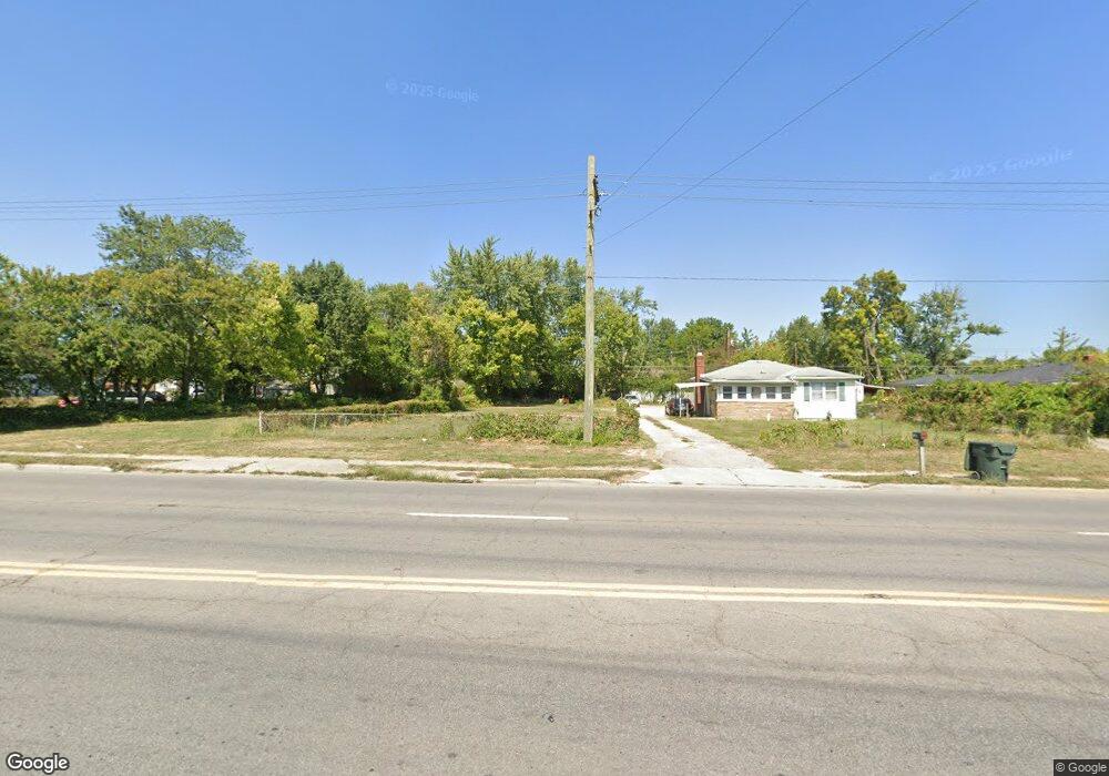
1284 Frank Rd Columbus, OH 43223
Estimated Value: $218,000 - $369,000
2
Beds
1
Bath
708
Sq Ft
$379/Sq Ft
Est. Value
About This Home
This home is located at 1284 Frank Rd, Columbus, OH 43223 and is currently estimated at $268,333, approximately $379 per square foot. 1284 Frank Rd is a home located in Franklin County with nearby schools including Finland Elementary School, Franklin Woods Intermediate School, and Finland Middle School.
Ownership History
Date
Name
Owned For
Owner Type
Purchase Details
Closed on
Feb 3, 2021
Sold by
Yasin Nael M
Bought by
1429 Properties Llc
Current Estimated Value
Purchase Details
Closed on
Dec 9, 2020
Sold by
Yasin Nael M and Yasin Nael
Bought by
1429 Properties Llc
Purchase Details
Closed on
Nov 10, 2016
Sold by
City Of Columbus Ohio
Bought by
Yasin Nael
Purchase Details
Closed on
Oct 15, 2015
Sold by
Central Ohio Community Improvement Corpo
Bought by
City Of Columbus Ohio
Purchase Details
Closed on
Dec 31, 2014
Sold by
Walk Adam T and Leonard Edward
Bought by
Central Ohio Community Improvement Corp
Purchase Details
Closed on
Jun 12, 1996
Sold by
Pless Shirley J
Bought by
Walk Adam T
Home Financials for this Owner
Home Financials are based on the most recent Mortgage that was taken out on this home.
Original Mortgage
$50,490
Interest Rate
8.05%
Mortgage Type
VA
Purchase Details
Closed on
Jan 16, 1990
Create a Home Valuation Report for This Property
The Home Valuation Report is an in-depth analysis detailing your home's value as well as a comparison with similar homes in the area
Home Values in the Area
Average Home Value in this Area
Purchase History
| Date | Buyer | Sale Price | Title Company |
|---|---|---|---|
| 1429 Properties Llc | -- | None Listed On Document | |
| 1429 Properties Llc | -- | None Available | |
| Yasin Nael | -- | None Available | |
| City Of Columbus Ohio | -- | None Available | |
| Central Ohio Community Improvement Corp | -- | None Available | |
| Walk Adam T | $49,500 | -- | |
| -- | -- | -- |
Source: Public Records
Mortgage History
| Date | Status | Borrower | Loan Amount |
|---|---|---|---|
| Previous Owner | Walk Adam T | $50,490 |
Source: Public Records
Tax History
| Year | Tax Paid | Tax Assessment Tax Assessment Total Assessment is a certain percentage of the fair market value that is determined by local assessors to be the total taxable value of land and additions on the property. | Land | Improvement |
|---|---|---|---|---|
| 2025 | $338 | $9,030 | $9,030 | -- |
| 2024 | $338 | $9,030 | $9,030 | -- |
| 2023 | $332 | $9,030 | $9,030 | $0 |
| 2022 | $472 | $9,420 | $9,420 | $0 |
| 2021 | $481 | $9,420 | $9,420 | $0 |
| 2020 | $479 | $9,420 | $9,420 | $0 |
| 2019 | $0 | $7,840 | $7,840 | $0 |
| 2018 | $0 | $7,840 | $7,840 | $0 |
| 2017 | $186 | $7,840 | $7,840 | $0 |
| 2016 | $158 | $12,530 | $3,850 | $8,680 |
| 2015 | -- | $12,530 | $3,850 | $8,680 |
| 2014 | $781 | $12,530 | $3,850 | $8,680 |
| 2013 | $1,058 | $14,735 | $4,515 | $10,220 |
Source: Public Records
Map
Nearby Homes
- 1657 Eastbrook Dr S
- 1834 Saint Lawrence Dr
- 1400 Brown Rd
- 2528 Dwiton Ct
- 1540 Little Ave
- 1640 Butterfly Ct
- 1962 Limetree Ct
- 2108 Willow Run Rd
- 2024 Grove Tree Ct
- 1543 Red Leaf Ln
- 1372 Stanwix Ct
- 1949 Big Run Bluffs Blvd
- 2072 Asher Ct
- 2210 October Ridge Dr
- 1521 October Ridge Ct
- 1463 Channel Place
- 1735 Dyer Rd
- 1122 Harrisburg Pike
- 1896 Dyer Rd
- 3816 Miltonsburg Dr
- 1280 Frank Rd
- 1288 Frank Rd
- 1278 Frank Rd
- 1366 Frank Rd
- 1275 Marsdale Ave
- 1265 Marsdale Ave
- 1285 Marsdale Ave
- 1291 Marsdale Ave
- 1253 Marsdale Ave
- 1372 Frank Rd
- 1241 Marsdale Ave
- 1295 Marsdale Ave
- 1200 Frank Rd
- 1919 Brown Rd
- 1369 Frank Rd
- 1278 Marsdale Ave
- 1278 Marsdale Ave
- 1100 Frank Rd
- 1290 Marsdale Ave
- 1901 Brown Rd
Your Personal Tour Guide
Ask me questions while you tour the home.