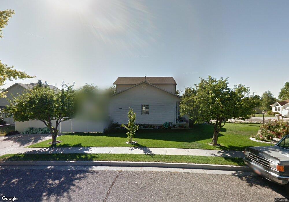
1286 Eastridge Cir Logan, UT 84321
Wilson NeighborhoodEstimated Value: $434,000 - $521,000
5
Beds
4
Baths
2,514
Sq Ft
$190/Sq Ft
Est. Value
About This Home
This home is located at 1286 Eastridge Cir, Logan, UT 84321 and is currently estimated at $478,895, approximately $190 per square foot. 1286 Eastridge Cir is a home located in Cache County with nearby schools including Wilson School, Mount Logan Middle School, and Logan High School.
Ownership History
Date
Name
Owned For
Owner Type
Purchase Details
Closed on
Jun 16, 2020
Sold by
Mayfield Charles E and Mayfield Michelle V
Bought by
Hansen Amanda and Hansen Nathan
Current Estimated Value
Home Financials for this Owner
Home Financials are based on the most recent Mortgage that was taken out on this home.
Original Mortgage
$275,500
Outstanding Balance
$243,669
Interest Rate
3.2%
Mortgage Type
New Conventional
Estimated Equity
$235,226
Purchase Details
Closed on
Oct 20, 2017
Sold by
Run Vann Bun and Run Kanha Eng
Bought by
Mayfield Charles E and Mayfield Michelle V
Home Financials for this Owner
Home Financials are based on the most recent Mortgage that was taken out on this home.
Original Mortgage
$250,381
Interest Rate
4.87%
Mortgage Type
FHA
Create a Home Valuation Report for This Property
The Home Valuation Report is an in-depth analysis detailing your home's value as well as a comparison with similar homes in the area
Home Values in the Area
Average Home Value in this Area
Purchase History
| Date | Buyer | Sale Price | Title Company |
|---|---|---|---|
| Hansen Amanda | -- | Cache Title Logan | |
| Mayfield Charles E | -- | American Secure Title |
Source: Public Records
Mortgage History
| Date | Status | Borrower | Loan Amount |
|---|---|---|---|
| Open | Hansen Amanda | $275,500 | |
| Previous Owner | Mayfield Charles E | $250,381 |
Source: Public Records
Tax History Compared to Growth
Tax History
| Year | Tax Paid | Tax Assessment Tax Assessment Total Assessment is a certain percentage of the fair market value that is determined by local assessors to be the total taxable value of land and additions on the property. | Land | Improvement |
|---|---|---|---|---|
| 2025 | $1,896 | $245,225 | $0 | $0 |
| 2024 | $1,947 | $243,905 | $0 | $0 |
| 2023 | $2,015 | $240,575 | $0 | $0 |
| 2022 | $1,782 | $198,720 | $0 | $0 |
| 2021 | $1,752 | $301,830 | $63,900 | $237,930 |
| 2020 | $1,582 | $245,301 | $63,900 | $181,401 |
| 2019 | $1,654 | $245,301 | $63,900 | $181,401 |
| 2018 | $1,637 | $221,640 | $63,900 | $157,740 |
| 2017 | $1,544 | $110,570 | $0 | $0 |
| 2016 | $1,601 | $110,570 | $0 | $0 |
| 2015 | $1,429 | $98,610 | $0 | $0 |
| 2014 | $1,292 | $98,610 | $0 | $0 |
| 2013 | -- | $98,610 | $0 | $0 |
Source: Public Records
Map
Nearby Homes
- 1279 Eastridge Dr
- 10 S 1300 E
- 128 S 1170 E
- 1383 Mount Logan Loop
- 1605 Mountain Rd
- 357 Paintbrush Ln
- 1374 E 260 N
- 147 Winding Way Unit 50
- 159 Winding Way Unit 49
- 1387 E 260 N
- 1034 Thrushwood Dr
- 240 N 1480 E
- 1045 Fox Farm Rd
- 28 River Pointe Dr
- 556 N 520 E
- 720 E 525 N Unit 32
- Cedar Ridge Plan at Shoreline Estates
- Strata Plan at Shoreline Estates
- Hamilton Plan at Shoreline Estates
- Manhattan Plan at Shoreline Estates
- 1284 Eastridge Cir
- 1287 Eastridge Dr
- 1306 Eastridge Cir
- 1280 Eastridge Cir
- 1302 Eastridge Cir
- 1289 Eastridge Cir
- 1311 Eastridge Dr
- 1294 Eastridge Cir
- 1285 Eastridge Cir
- 1281 Eastridge Cir
- 133 S 1350 E
- 141 S 1350 E
- 1335 Eastridge Dr
- 127 S 1350 E
- 1290 E 100 S
- 1269 Eastridge Cir
- 1273 Eastridge Cir
- 1312 E 100 S
- 1272 Eastridge Dr
- 1288 Eastridge Dr