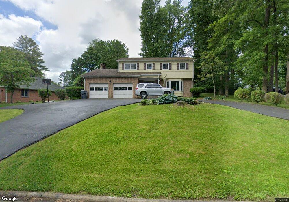
129 Maxwell Dr Bristol, TN 37620
Estimated Value: $370,000 - $433,000
4
Beds
3
Baths
2,482
Sq Ft
$158/Sq Ft
Est. Value
About This Home
This home is located at 129 Maxwell Dr, Bristol, TN 37620 and is currently estimated at $391,440, approximately $157 per square foot. 129 Maxwell Dr is a home located in Sullivan County with nearby schools including Holston View Elementary School, Vance Middle School, and Tennessee High School.
Ownership History
Date
Name
Owned For
Owner Type
Purchase Details
Closed on
Mar 16, 2020
Sold by
Cousins Matthew S and Cousins Shaylene M
Bought by
Cousins Mathew S
Current Estimated Value
Home Financials for this Owner
Home Financials are based on the most recent Mortgage that was taken out on this home.
Original Mortgage
$196,000
Outstanding Balance
$172,497
Interest Rate
3.4%
Mortgage Type
VA
Estimated Equity
$218,943
Purchase Details
Closed on
Nov 29, 2010
Sold by
Browne David L
Bought by
Cousins Mathew S
Home Financials for this Owner
Home Financials are based on the most recent Mortgage that was taken out on this home.
Original Mortgage
$205,000
Interest Rate
4.31%
Purchase Details
Closed on
Jan 1, 1983
Create a Home Valuation Report for This Property
The Home Valuation Report is an in-depth analysis detailing your home's value as well as a comparison with similar homes in the area
Purchase History
| Date | Buyer | Sale Price | Title Company |
|---|---|---|---|
| Cousins Mathew S | -- | Evergreen Ttl & Closing Llc | |
| Cousins Mathew S | $205,000 | -- | |
| -- | $88,000 | -- |
Source: Public Records
Mortgage History
| Date | Status | Borrower | Loan Amount |
|---|---|---|---|
| Open | Cousins Mathew S | $196,000 | |
| Closed | Cousins Mathew S | $205,000 |
Source: Public Records
Tax History
| Year | Tax Paid | Tax Assessment Tax Assessment Total Assessment is a certain percentage of the fair market value that is determined by local assessors to be the total taxable value of land and additions on the property. | Land | Improvement |
|---|---|---|---|---|
| 2025 | -- | $114,325 | $7,675 | $106,650 |
| 2024 | -- | $59,100 | $6,625 | $52,475 |
| 2023 | $2,596 | $59,100 | $6,625 | $52,475 |
| 2022 | $2,596 | $59,100 | $6,625 | $52,475 |
| 2021 | $2,596 | $59,100 | $6,625 | $52,475 |
| 2020 | $1,426 | $59,100 | $6,625 | $52,475 |
| 2019 | $2,625 | $55,475 | $6,625 | $48,850 |
| 2018 | $2,614 | $55,475 | $6,625 | $48,850 |
| 2017 | $2,614 | $55,475 | $6,625 | $48,850 |
| 2016 | $2,256 | $46,750 | $6,625 | $40,125 |
| 2014 | $2,129 | $46,745 | $0 | $0 |
Source: Public Records
Map
Nearby Homes
- 5820 Old Jonesboro Rd
- 100 Canterbury Place
- 117 Canterbury Place
- 305 Overbrook Dr
- 234 Bradford Ln
- 141 Queensgate
- 150 Brighton Place
- 2070 King College Rd
- 154 Brighton Place
- 121 Queensgate
- 215 Brighton Place
- 170 Brighton Place
- 224 Brighton Place
- 207 Monroe Dr
- 304 Monroe Dr
- 340 Monroe Dr
- 348 Monroe Dr
- 334 Monroe Dr
- 230 Monroe Dr
- 296 Monroe Dr
- 125 Maxwell Dr
- 131 Maxwell Dr
- 0 Maxwell Dr
- 5833 Old Jonesboro Rd
- 121 Maxwell Dr
- 5829 Old Jonesboro Rd
- 122 Maxwell Dr
- 120 Maxwell Dr
- 116 Maxwell Dr
- 5841 Old Jonesboro Rd
- 112 Maxwell Dr
- 117 Maxwell Dr
- 5838 Old Jonesboro Rd
- 5790 Old Jonesboro Rd
- 108 Maxwell Dr
- 136 Maxwell Dr
- 5845 Old Jonesboro Rd
- 5842 Old Jonesboro Rd
- 405 Gaffney Rd
- 401 Gaffney Rd
Your Personal Tour Guide
Ask me questions while you tour the home.