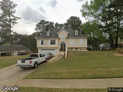
129 Rockport Dr McDonough, GA 30253
Estimated Value: $355,739 - $388,000
4
Beds
3
Baths
2,611
Sq Ft
$141/Sq Ft
Est. Value
About This Home
This home is located at 129 Rockport Dr, McDonough, GA 30253 and is currently estimated at $368,435, approximately $141 per square foot. 129 Rockport Dr is a home located in Henry County with nearby schools including Union Grove Middle School, Union Grove High School, and Hickory Flat Elementary School.
Ownership History
Date
Name
Owned For
Owner Type
Purchase Details
Closed on
May 9, 2019
Sold by
Dial Stephen G
Bought by
Jarrett Frances A and Webster Necola L
Current Estimated Value
Home Financials for this Owner
Home Financials are based on the most recent Mortgage that was taken out on this home.
Original Mortgage
$216,015
Outstanding Balance
$193,785
Interest Rate
4.75%
Mortgage Type
FHA
Estimated Equity
$174,650
Purchase Details
Closed on
Aug 30, 2000
Sold by
Carter Charles and Carter Wanda J
Bought by
Dial Stephen G and Dial Carol S
Home Financials for this Owner
Home Financials are based on the most recent Mortgage that was taken out on this home.
Original Mortgage
$136,600
Interest Rate
8.11%
Mortgage Type
New Conventional
Purchase Details
Closed on
Mar 7, 1997
Sold by
Mnw Constr Co
Bought by
Carter Charles Wanda
Create a Home Valuation Report for This Property
The Home Valuation Report is an in-depth analysis detailing your home's value as well as a comparison with similar homes in the area
Home Values in the Area
Average Home Value in this Area
Purchase History
| Date | Buyer | Sale Price | Title Company |
|---|---|---|---|
| Jarrett Frances A | $220,000 | -- | |
| Dial Stephen G | $149,000 | -- | |
| Carter Charles Wanda | $130,000 | -- |
Source: Public Records
Mortgage History
| Date | Status | Borrower | Loan Amount |
|---|---|---|---|
| Open | Jarrett Frances A | $216,015 | |
| Previous Owner | Dial Stephen G | $83,100 | |
| Previous Owner | Dial Stephen G | $136,400 | |
| Previous Owner | Dial Stephen G | $136,600 | |
| Closed | Carter Charles Wanda | $0 |
Source: Public Records
Tax History Compared to Growth
Tax History
| Year | Tax Paid | Tax Assessment Tax Assessment Total Assessment is a certain percentage of the fair market value that is determined by local assessors to be the total taxable value of land and additions on the property. | Land | Improvement |
|---|---|---|---|---|
| 2024 | $5,484 | $136,080 | $16,000 | $120,080 |
| 2023 | $5,253 | $134,920 | $14,000 | $120,920 |
| 2022 | $4,075 | $104,200 | $14,000 | $90,200 |
| 2021 | $3,501 | $89,240 | $14,000 | $75,240 |
| 2020 | $3,189 | $81,120 | $12,000 | $69,120 |
| 2019 | $892 | $75,840 | $10,000 | $65,840 |
| 2018 | $892 | $71,720 | $10,000 | $61,720 |
| 2016 | $821 | $65,440 | $8,000 | $57,440 |
| 2015 | $817 | $61,560 | $8,000 | $53,560 |
| 2014 | $865 | $63,320 | $8,000 | $55,320 |
Source: Public Records
Map
Nearby Homes
- 153 Rockport Dr
- 901 Arbor Way
- 756 Stonehaven Chase
- 237 Cranapple Ln
- 312 Wichita Way
- 212 Himalaya Way
- 140 Harpy Dr
- 418 Crosshaven Way
- 1401 Aberdeen Ct
- 765 Rock Ln
- 1160 Strath Clyde Way
- 1152 Strath Clyde Way
- 1150 Strath Clyde Way
- 334 Royal Crescent Way
- 1120 Strath Clyde Way
- 250 Kensington Trace
- 329 Royal Crescent Way
- 243 Kensington Trace
- 1181 Paramount Dr
- 214 Kensington Trace
- 129 Rockport Dr
- 141 Rockport Dr
- 123 Rockport Dr
- 608 Castlebar Way
- 134 Rockport Dr Unit 32
- 134 Rockport Dr
- 147 Rockport Dr
- 128 Rockport Dr
- 140 Rockport Dr
- 614 Castlebar Way
- 0 Castlebar Way
- 122 Rockport Dr
- 113 Rockport Dr
- 116 Rockport Dr
- 153 Rockport Dr Unit 16
- 605 Castlebar Way
- 609 Castlebar Way
- 615 Castlebar Way
- 620 Castlebar Way
- 152 Rockport Dr