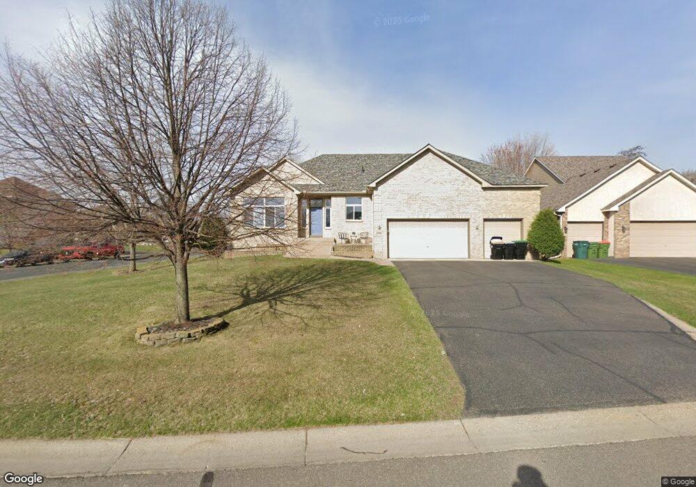
12908 Avocet St NW Coon Rapids, MN 55448
Estimated Value: $530,212 - $599,000
5
Beds
3
Baths
1,965
Sq Ft
$292/Sq Ft
Est. Value
About This Home
This home is located at 12908 Avocet St NW, Coon Rapids, MN 55448 and is currently estimated at $573,803, approximately $292 per square foot. 12908 Avocet St NW is a home located in Anoka County with nearby schools including Sand Creek Elementary School, Coon Rapids Middle School, and Coon Rapids Senior High School.
Ownership History
Date
Name
Owned For
Owner Type
Purchase Details
Closed on
May 31, 2005
Sold by
Knisley Construction Inc
Bought by
Schmitt Katherine S
Current Estimated Value
Purchase Details
Closed on
Jun 17, 2002
Sold by
Shamrock Development Inc
Bought by
Knisley Construction Inc
Create a Home Valuation Report for This Property
The Home Valuation Report is an in-depth analysis detailing your home's value as well as a comparison with similar homes in the area
Home Values in the Area
Average Home Value in this Area
Purchase History
| Date | Buyer | Sale Price | Title Company |
|---|---|---|---|
| Schmitt Katherine S | $379,966 | -- | |
| Knisley Construction Inc | $760,000 | -- |
Source: Public Records
Mortgage History
| Date | Status | Borrower | Loan Amount |
|---|---|---|---|
| Closed | Knisley Construction Inc | -- |
Source: Public Records
Tax History Compared to Growth
Tax History
| Year | Tax Paid | Tax Assessment Tax Assessment Total Assessment is a certain percentage of the fair market value that is determined by local assessors to be the total taxable value of land and additions on the property. | Land | Improvement |
|---|---|---|---|---|
| 2025 | $4,869 | $481,000 | $109,300 | $371,700 |
| 2024 | $4,869 | $453,700 | $104,500 | $349,200 |
| 2023 | $4,738 | $520,400 | $99,800 | $420,600 |
| 2022 | $4,706 | $477,900 | $99,800 | $378,100 |
| 2021 | $4,467 | $418,200 | $95,000 | $323,200 |
| 2020 | $4,615 | $388,700 | $80,800 | $307,900 |
| 2019 | $4,539 | $384,400 | $71,300 | $313,100 |
| 2018 | $4,417 | $367,500 | $0 | $0 |
| 2017 | $4,256 | $347,000 | $0 | $0 |
| 2016 | $4,292 | $324,100 | $0 | $0 |
| 2015 | -- | $324,100 | $53,000 | $271,100 |
| 2014 | -- | $298,000 | $58,800 | $239,200 |
Source: Public Records
Map
Nearby Homes
- 1520 129th Ave NW
- 12796 Bluebird St NW
- 1234 128th Cir NW
- 12859 Grouse St NW
- 1450 126th Ln NW
- 1593 126th Ln NW
- 1687 131st Ln NW
- 12554 Grouse St NW
- 12463 Drake St NW
- 1776 133rd Ave NW
- 12488 Unity St NW
- 1625 124th Ave NW
- 1930 127th Cir NW
- 12365 Jay St NW
- 899 123rd Ln NW
- 12760 Raven St NW
- 1727 121st Ln NW
- 2147 125th Ln NW
- 12010 Eagle St NW
- 13519 Partridge Cir NW
- 12922 Avocet St NW
- 12907 Bluebird St NW
- 12917 Bluebird St NW
- 12936 Avocet St NW
- 1299 129th Ave NW
- 1306 129th Ave NW
- 12931 Bluebird St NW
- 1294 129th Ln NW
- 1338 129th Ave NW
- 1338 129th Ave NW
- 12950 Avocet St NW
- 12889 Avocet St NW
- 1291 129th Ave NW
- 12945 Bluebird St NW
- 1286 129th Ln NW
- 12860 Avocet St NW
- 12877 Avocet St NW
- 12900 Bluebird St NW
- 12964 Avocet St NW
- 12964 Avocet St NW