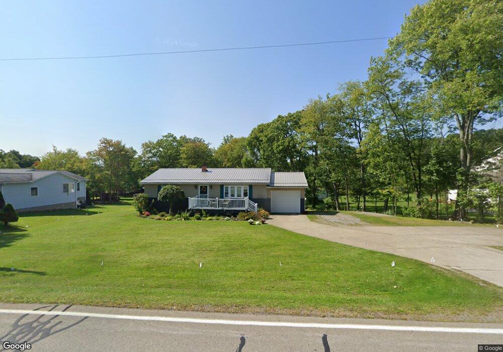
12977 Leslie Rd Meadville, PA 16335
Estimated Value: $177,255 - $214,000
--
Bed
--
Bath
--
Sq Ft
0.34
Acres
About This Home
This home is located at 12977 Leslie Rd, Meadville, PA 16335 and is currently estimated at $196,564. 12977 Leslie Rd is a home located in Crawford County with nearby schools including Neason Hill Elementary School, Meadville Middle School, and Meadville Area Senior High School.
Ownership History
Date
Name
Owned For
Owner Type
Purchase Details
Closed on
Aug 8, 2014
Sold by
Staab Brian A and Staab Jenna L
Bought by
Davis Robert A and Davis Deborah Ross
Current Estimated Value
Purchase Details
Closed on
Mar 7, 2007
Sold by
Lawrence Michael Jr George J and Lawrence Michael
Bought by
Staab Brian A
Home Financials for this Owner
Home Financials are based on the most recent Mortgage that was taken out on this home.
Original Mortgage
$79,273
Interest Rate
6.33%
Mortgage Type
FHA
Create a Home Valuation Report for This Property
The Home Valuation Report is an in-depth analysis detailing your home's value as well as a comparison with similar homes in the area
Home Values in the Area
Average Home Value in this Area
Purchase History
| Date | Buyer | Sale Price | Title Company |
|---|---|---|---|
| Davis Robert A | $92,000 | None Available | |
| Staab Brian A | $79,900 | None Available |
Source: Public Records
Mortgage History
| Date | Status | Borrower | Loan Amount |
|---|---|---|---|
| Previous Owner | Staab Brian A | $79,273 |
Source: Public Records
Tax History Compared to Growth
Tax History
| Year | Tax Paid | Tax Assessment Tax Assessment Total Assessment is a certain percentage of the fair market value that is determined by local assessors to be the total taxable value of land and additions on the property. | Land | Improvement |
|---|---|---|---|---|
| 2025 | $1,055 | $38,921 | $2,000 | $36,921 |
| 2024 | $1,522 | $38,921 | $2,000 | $36,921 |
| 2023 | $1,561 | $38,921 | $2,000 | $36,921 |
| 2022 | $3,136 | $38,921 | $2,000 | $36,921 |
| 2021 | $3,063 | $38,921 | $2,000 | $36,921 |
| 2020 | $3,063 | $38,921 | $2,000 | $36,921 |
| 2019 | $3,063 | $38,921 | $2,000 | $36,921 |
| 2018 | $2,918 | $38,921 | $2,000 | $36,921 |
| 2017 | $2,886 | $38,921 | $2,000 | $36,921 |
| 2016 | $899 | $38,921 | $2,000 | $36,921 |
| 2015 | $899 | $38,921 | $2,000 | $36,921 |
| 2014 | -- | $34,400 | $2,000 | $32,400 |
Source: Public Records
Map
Nearby Homes
- 12988 Raymond Dr
- 20865 Blooming Valley Rd
- 13329 Calvin St
- 12336 Leslie Rd
- 3214-024 Blooming Valley Rd
- 3210-72-6 Blooming Valley Rd
- 3210-072-6 Blooming Valley Rd
- 21757 Star Route
- 20899 Star Route
- 668 Limber Rd
- 802 Brawley Ave
- 673 Washington St
- 0000 Jefferson St
- 4.5 Acres 0000 Jefferson St
- 712 State St
- 501 Sunset Dr
- 236 Grandview Ave
- 3213-020-11-12-14 Leslie Rd
- 286 Jefferson St
- 826 Irvin Ave
- 12963 Leslie Rd
- 12963 Leslie Rd
- 21242 Serenity Dr
- 12944 Leslie Rd
- 21253 Serenity Dr
- 12930 Leslie Rd
- 12923 Leslie Rd
- 12884 Leslie Rd
- 21234 Serenity Dr
- 12988 Leslie Rd
- 21229 Serenity Dr
- 21384 Beverly Dr
- 13025 Leslie Rd
- 13002 Leslie Rd
- 21204 Serenity Dr
- 12870 Leslie Rd
- 13063 Leslie Rd
- 21406 Beverly Dr
- 21389 Beverly Dr
- 21203 Serenity Dr