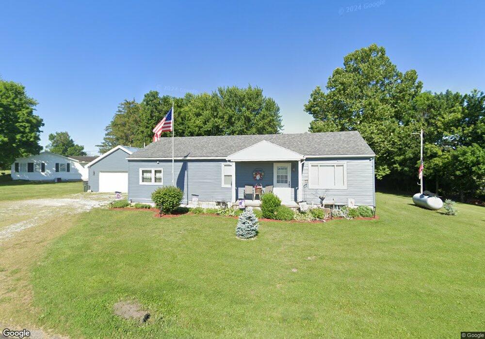
1299 Clinton Rd Chillicothe, OH 45601
Estimated Value: $169,423 - $231,000
3
Beds
1
Bath
1,200
Sq Ft
$177/Sq Ft
Est. Value
About This Home
This home is located at 1299 Clinton Rd, Chillicothe, OH 45601 and is currently estimated at $212,106, approximately $176 per square foot. 1299 Clinton Rd is a home located in Ross County with nearby schools including Unioto Elementary School, Unioto Middle School, and Unioto High School.
Ownership History
Date
Name
Owned For
Owner Type
Purchase Details
Closed on
Apr 21, 2025
Sold by
Staffin Jeri Lynne and Staffin Jeri Lynn
Bought by
Sutton Jeri Lynn and Sutton Shawn A
Current Estimated Value
Purchase Details
Closed on
Apr 8, 2008
Sold by
Staffin Douglas
Bought by
Staffin Jeri Lynn
Purchase Details
Closed on
Aug 18, 2005
Sold by
Ratcliff George A and Ratcliff Clara Jane
Bought by
Staffin Douglas and Staffin Jeri Lynne
Create a Home Valuation Report for This Property
The Home Valuation Report is an in-depth analysis detailing your home's value as well as a comparison with similar homes in the area
Home Values in the Area
Average Home Value in this Area
Purchase History
| Date | Buyer | Sale Price | Title Company |
|---|---|---|---|
| Sutton Jeri Lynn | -- | None Listed On Document | |
| Sutton Jeri Lynn | -- | None Listed On Document | |
| Staffin Jeri Lynn | -- | None Available | |
| Staffin Douglas | -- | None Available |
Source: Public Records
Tax History Compared to Growth
Tax History
| Year | Tax Paid | Tax Assessment Tax Assessment Total Assessment is a certain percentage of the fair market value that is determined by local assessors to be the total taxable value of land and additions on the property. | Land | Improvement |
|---|---|---|---|---|
| 2024 | $1,404 | $39,710 | $4,990 | $34,720 |
| 2023 | $1,431 | $39,710 | $4,990 | $34,720 |
| 2022 | $1,434 | $39,710 | $4,990 | $34,720 |
| 2021 | $1,153 | $29,870 | $3,870 | $26,000 |
| 2020 | $1,159 | $29,870 | $3,870 | $26,000 |
| 2019 | $1,159 | $29,870 | $3,870 | $26,000 |
| 2018 | $1,036 | $26,160 | $3,590 | $22,570 |
| 2017 | $1,037 | $26,160 | $3,590 | $22,570 |
| 2016 | $1,011 | $26,160 | $3,590 | $22,570 |
| 2015 | $951 | $24,320 | $3,590 | $20,730 |
| 2014 | $929 | $24,320 | $3,590 | $20,730 |
| 2013 | $933 | $24,320 | $3,590 | $20,730 |
Source: Public Records
Map
Nearby Homes
- 13223 Pleasant Valley Rd
- 1036 Clinton Rd
- 12690 Pleasant Valley Rd
- 2153 Egypt Pike
- 265 Brookside Dr
- 45 Custer Dr
- 18 Sarah Ct
- 25 Woodland Way
- 2083 Anderson Station Rd
- 365 Golfview Dr
- 88 Fruit Hill Dr
- 14996 Pleasant Valley Rd Unit Lot 60
- 14996 Pleasant Valley Rd Unit Lot 70
- 14996 Pleasant Valley Rd Unit Lot 53
- 11303 County Road 550
- 313 Goodale Dr
- 310 Almahurst Dr
- 847 Pine St
- 23 Shawnee Dr
- 320 Summerhill Dr
- 1263 Clinton Rd
- 0 County Road 550
- 0 County Road 550
- 0 County Road 550
- 12930 Pleasant Valley Rd
- 12918 Pleasant Valley Rd
- 12876 Pleasant Valley Rd
- 76 Rolling Meadows Dr
- 12848 Pleasant Valley Rd
- 98 Rolling Meadows Dr
- 112 Rolling Meadows Dr
- 1128 Clinton Rd
- 12828 Pleasant Valley Rd
- 114 Goldenrod Dr
- 12804 Pleasant Valley Rd
- 130 Goldenrod Dr
- 130 Rolling Meadows Dr
- 48 Goldenrod Dr
- 146 Goldenrod Dr
- 33 Clover Cir