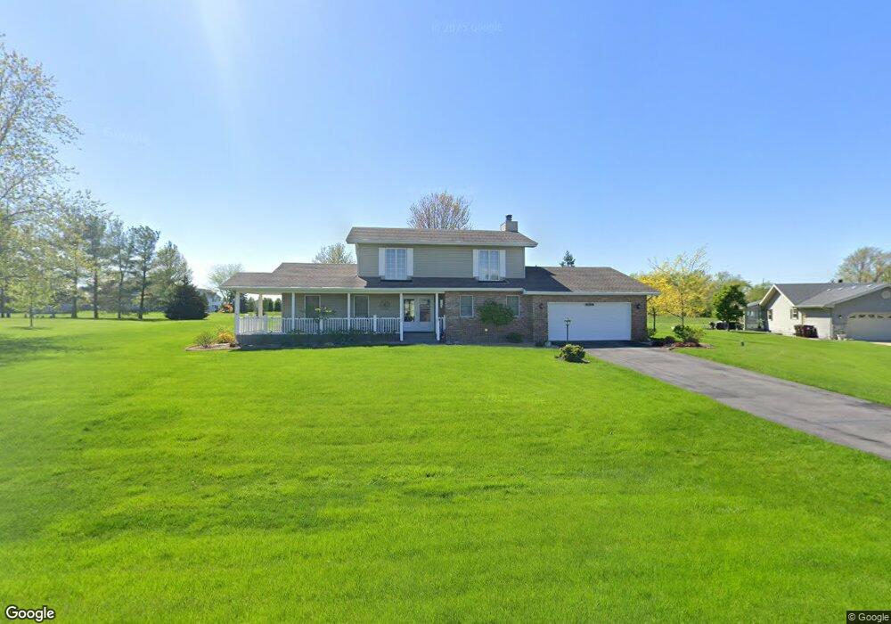
12996 Pierce Ct Crown Point, IN 46307
Estimated Value: $374,702 - $445,000
3
Beds
3
Baths
1,968
Sq Ft
$208/Sq Ft
Est. Value
About This Home
This home is located at 12996 Pierce Ct, Crown Point, IN 46307 and is currently estimated at $410,176, approximately $208 per square foot. 12996 Pierce Ct is a home located in Lake County with nearby schools including Dwight D. Eisenhower Elementary School, Colonel John Wheeler Middle School, and Crown Point High School.
Ownership History
Date
Name
Owned For
Owner Type
Purchase Details
Closed on
Dec 19, 2011
Sold by
Becker Robert A and Becker Babette H
Bought by
Becker Robert A and Becker Babette H
Current Estimated Value
Purchase Details
Closed on
Jul 22, 2011
Sold by
Becker Robert A and Becker Babette H
Bought by
Becker Robert A and Becker Babette H
Purchase Details
Closed on
Nov 22, 2005
Sold by
Becker Robert A and Becker Babette H
Bought by
Becker Robert A and Becker Babette H
Create a Home Valuation Report for This Property
The Home Valuation Report is an in-depth analysis detailing your home's value as well as a comparison with similar homes in the area
Home Values in the Area
Average Home Value in this Area
Purchase History
| Date | Buyer | Sale Price | Title Company |
|---|---|---|---|
| Becker Robert A | -- | None Available | |
| Becker Robert A | -- | None Available | |
| Becker Robert A | -- | -- |
Source: Public Records
Tax History
| Year | Tax Paid | Tax Assessment Tax Assessment Total Assessment is a certain percentage of the fair market value that is determined by local assessors to be the total taxable value of land and additions on the property. | Land | Improvement |
|---|---|---|---|---|
| 2025 | $2,802 | $336,700 | $55,500 | $281,200 |
| 2024 | $6,335 | $317,000 | $55,500 | $261,500 |
| 2023 | $2,717 | $298,100 | $55,500 | $242,600 |
| 2022 | $2,854 | $284,300 | $55,500 | $228,800 |
| 2021 | $2,507 | $265,600 | $44,400 | $221,200 |
| 2020 | $2,536 | $256,500 | $44,400 | $212,100 |
| 2019 | $2,607 | $254,400 | $44,400 | $210,000 |
| 2018 | $2,673 | $248,100 | $44,400 | $203,700 |
| 2017 | $2,654 | $244,200 | $44,400 | $199,800 |
| 2016 | $2,641 | $242,000 | $44,400 | $197,600 |
| 2014 | $2,324 | $232,500 | $44,400 | $188,100 |
| 2013 | $2,215 | $223,800 | $44,400 | $179,400 |
Source: Public Records
Map
Nearby Homes
- 1051 W 129th Ave
- 12819 Grant St
- 12938 Hayes St
- 253 W 129th Ave Unit 1
- 809 W 126th Ct
- 2184 W 129th Place
- 13209 Roosevelt Place
- 1790 W 134th Ct
- 13181 Taft St
- 12728 Ellsworth St
- 255 Nomo Place
- 2725 W 127th Ln
- 283 Nomo Place
- 13378 Taney St
- 244 Sawgrass Dr
- 246 Sawgrass Dr
- 1426 Rainy Brook Way
- 323 E 129th Place
- 248 Sawgrass Dr
- 12492 Washington St
- 13024 Pierce Ct
- 12968 Pierce Ct
- 12997 Pierce Ct
- 13025 Pierce Ct
- 12940 Pierce Ct
- 1410 W 130th Place
- 13052 Pierce Ct
- 13059 Lincoln St
- 1123 W 130th Ave
- 12994 Fillmore Place
- 1203 W 129th Ave
- 1211 W 129th Ave
- 1339 W 129th Ave
- 1486 W 130th Place
- 1147 W 130th Ave
- 1315 W 129th Ave
- 13074 Pierce Ct
- 1403 W 129th Ave
- 13046 Pierce Ct
- 1011 W 129th Ave
Your Personal Tour Guide
Ask me questions while you tour the home.