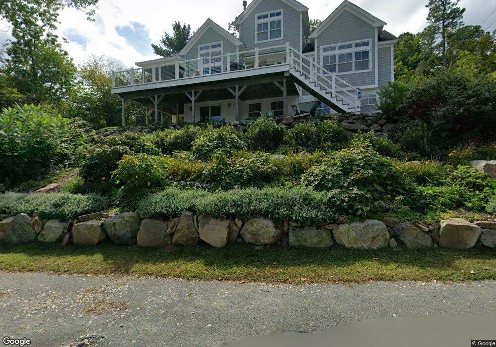
13 Cononicus Rd Gloucester, MA 01930
West Gloucester NeighborhoodEstimated Value: $1,160,000 - $1,430,861
4
Beds
5
Baths
2,494
Sq Ft
$537/Sq Ft
Est. Value
About This Home
This home is located at 13 Cononicus Rd, Gloucester, MA 01930 and is currently estimated at $1,340,215, approximately $537 per square foot. 13 Cononicus Rd is a home located in Essex County with nearby schools including West Parish, Ralph B O'maley Middle School, and Gloucester High School.
Ownership History
Date
Name
Owned For
Owner Type
Purchase Details
Closed on
Apr 29, 2022
Sold by
Seaworks Llc
Bought by
Surette David S and Surette Maureen M
Current Estimated Value
Purchase Details
Closed on
Mar 6, 2015
Sold by
Chardo Leonard C
Bought by
Surette David J and Surette Maureen M
Home Financials for this Owner
Home Financials are based on the most recent Mortgage that was taken out on this home.
Original Mortgage
$495,000
Interest Rate
3.64%
Mortgage Type
New Conventional
Purchase Details
Closed on
Nov 7, 2013
Sold by
Bonina Andrew J and Dolan Deborah M
Bought by
Chardo Leonard C
Purchase Details
Closed on
May 17, 2007
Sold by
Lane Barbara O and Donoghue Mary Ellen
Bought by
Bonina Andrew J
Create a Home Valuation Report for This Property
The Home Valuation Report is an in-depth analysis detailing your home's value as well as a comparison with similar homes in the area
Home Values in the Area
Average Home Value in this Area
Purchase History
| Date | Buyer | Sale Price | Title Company |
|---|---|---|---|
| Surette David S | $50,000 | None Available | |
| Surette David J | $712,500 | -- | |
| Chardo Leonard C | $100,000 | -- | |
| Bonina Andrew J | $275,000 | -- |
Source: Public Records
Mortgage History
| Date | Status | Borrower | Loan Amount |
|---|---|---|---|
| Previous Owner | Surette David J | $495,000 |
Source: Public Records
Tax History
| Year | Tax Paid | Tax Assessment Tax Assessment Total Assessment is a certain percentage of the fair market value that is determined by local assessors to be the total taxable value of land and additions on the property. | Land | Improvement |
|---|---|---|---|---|
| 2025 | $11,924 | $1,226,800 | $316,000 | $910,800 |
| 2024 | $11,789 | $1,211,600 | $300,800 | $910,800 |
| 2023 | $11,275 | $1,064,700 | $268,600 | $796,100 |
| 2022 | $10,358 | $883,000 | $185,300 | $697,700 |
| 2021 | $10,083 | $810,500 | $168,200 | $642,300 |
| 2020 | $10,308 | $836,000 | $168,200 | $667,800 |
| 2019 | $9,875 | $778,200 | $168,200 | $610,000 |
| 2018 | $9,629 | $744,700 | $168,200 | $576,500 |
| 2017 | $9,399 | $712,600 | $160,200 | $552,400 |
| 2016 | $8,237 | $605,200 | $167,200 | $438,000 |
| 2015 | $1,940 | $142,100 | $142,100 | $0 |
Source: Public Records
Map
Nearby Homes
- 5 Samoset Rd Unit B
- 24 Cobblestone Ln Unit 603
- 5 Lepage Ln
- 145 Essex Ave Unit 402
- 3 Rockland St
- 5 Marshfield St
- 15 Harvard St
- 13 Leslie o Johnson Rd
- 368 Essex Ave
- 6 Monroe Ct
- 20 Beacon St
- 20 Beacon St Unit 2
- 20 Beacon St Unit 1
- 120 Washington St
- 13 Honeysuckle Rd
- 98 Maplewood Ave
- 8 Mystic Ave
- 13 Mystic Ave
- 9 Cleveland Place
- 31 Echo Ave
- 15 Cononicus Rd
- 30 Uncas Rd
- 12 Cononicus Rd
- 27 Uncas Rd
- 16 Cononicus Rd
- 29 Uncas Rd Unit 2
- 29 Uncas Rd Unit 1
- 26 Uncas Rd
- 35 Massasoit Rd Unit B
- 25A Uncas Rd Unit A
- 25 Uncas Rd
- 33 King Philip Rd
- 24 Uncas Rd
- 31 King Philip Rd
- 25 King Philip Rd
- 20 Uncas Rd
- 21 Uncas Rd
- 18 Uncas Rd
- 19 Uncas Rd Unit B
- 16 Uncas Rd
Your Personal Tour Guide
Ask me questions while you tour the home.