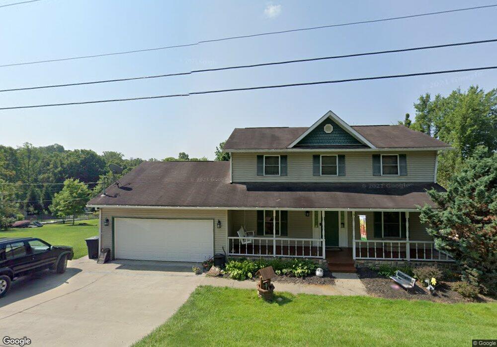
13 Devin Ln Morgantown, WV 26508
Estimated Value: $326,000 - $369,000
4
Beds
3
Baths
1,836
Sq Ft
$188/Sq Ft
Est. Value
About This Home
This home is located at 13 Devin Ln, Morgantown, WV 26508 and is currently estimated at $344,714, approximately $187 per square foot. 13 Devin Ln is a home located in Monongalia County with nearby schools including Ridgedale Elementary School, South Middle School, and Morgantown High School.
Ownership History
Date
Name
Owned For
Owner Type
Purchase Details
Closed on
Oct 27, 2010
Sold by
Wilson David L and Wilson Tamara L
Bought by
Croston Paul D and Croston Stephanie Jo
Current Estimated Value
Home Financials for this Owner
Home Financials are based on the most recent Mortgage that was taken out on this home.
Original Mortgage
$205,236
Outstanding Balance
$134,211
Interest Rate
4.25%
Mortgage Type
FHA
Estimated Equity
$210,503
Create a Home Valuation Report for This Property
The Home Valuation Report is an in-depth analysis detailing your home's value as well as a comparison with similar homes in the area
Home Values in the Area
Average Home Value in this Area
Purchase History
| Date | Buyer | Sale Price | Title Company |
|---|---|---|---|
| Croston Paul D | $208,000 | None Available |
Source: Public Records
Mortgage History
| Date | Status | Borrower | Loan Amount |
|---|---|---|---|
| Open | Croston Paul D | $205,236 |
Source: Public Records
Tax History Compared to Growth
Tax History
| Year | Tax Paid | Tax Assessment Tax Assessment Total Assessment is a certain percentage of the fair market value that is determined by local assessors to be the total taxable value of land and additions on the property. | Land | Improvement |
|---|---|---|---|---|
| 2025 | $1,314 | $122,940 | $22,320 | $100,620 |
| 2024 | $1,314 | $123,960 | $22,320 | $101,640 |
| 2023 | $1,321 | $123,960 | $22,320 | $101,640 |
| 2022 | $1,252 | $122,160 | $22,320 | $99,840 |
| 2021 | $1,258 | $122,160 | $22,320 | $99,840 |
| 2020 | $1,274 | $123,180 | $22,320 | $100,860 |
| 2019 | $1,229 | $117,960 | $22,320 | $95,640 |
| 2018 | $1,244 | $118,980 | $22,320 | $96,660 |
| 2017 | $1,237 | $117,720 | $21,060 | $96,660 |
| 2016 | $1,256 | $118,800 | $21,060 | $97,740 |
| 2015 | $1,099 | $108,720 | $21,060 | $87,660 |
| 2014 | $1,037 | $107,580 | $20,220 | $87,360 |
Source: Public Records
Map
Nearby Homes
- 1248 Goshen Rd
- 3228 Ridgedale Rd
- 127 Landing Dr
- 52 Owl St
- 53 Owl St
- 2 Chickadee Ln
- TBD Humphreys Rd
- 48 Ringold Ln
- 1256 Grafton Rd
- TBD Pine Ridge Rd
- 439 Blackberry Ridge Dr
- Lot 2 Fieldstone Dr
- Lot 11 Rockwell Ct
- 1256 Four H Camp Rd
- Lot 10 Rockwell Ct
- Lot 9 Rockwell Ct
- 108 Twin Ponds Ln
- 114 Nichole St
- TBD Benton Grove Rd
- 687 Cobun Creek Rd