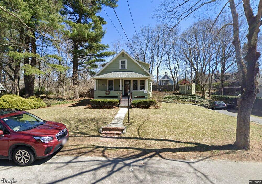
13 Hanscom Ave Reading, MA 01867
Estimated Value: $871,000 - $919,818
3
Beds
3
Baths
1,784
Sq Ft
$508/Sq Ft
Est. Value
About This Home
This home is located at 13 Hanscom Ave, Reading, MA 01867 and is currently estimated at $905,705, approximately $507 per square foot. 13 Hanscom Ave is a home located in Middlesex County with nearby schools including Birch Meadow Elementary School, Arthur W. Coolidge Middle School, and Reading Memorial High School.
Ownership History
Date
Name
Owned For
Owner Type
Purchase Details
Closed on
Mar 10, 2022
Sold by
Clopper Peter M and Clopper Michele A
Bought by
Clopper Rt and Clopper
Current Estimated Value
Purchase Details
Closed on
Apr 2, 1993
Sold by
Kowalski Stephen B and Kowalski Debra J
Bought by
Clopper Peter and Clopper Michele A
Create a Home Valuation Report for This Property
The Home Valuation Report is an in-depth analysis detailing your home's value as well as a comparison with similar homes in the area
Home Values in the Area
Average Home Value in this Area
Purchase History
| Date | Buyer | Sale Price | Title Company |
|---|---|---|---|
| Clopper Rt | -- | None Available | |
| Clopper Peter | $189,000 | -- |
Source: Public Records
Mortgage History
| Date | Status | Borrower | Loan Amount |
|---|---|---|---|
| Previous Owner | Clopper Peter | $182,000 | |
| Previous Owner | Clopper Peter | $100,000 | |
| Previous Owner | Clopper Peter | $185,000 |
Source: Public Records
Tax History
| Year | Tax Paid | Tax Assessment Tax Assessment Total Assessment is a certain percentage of the fair market value that is determined by local assessors to be the total taxable value of land and additions on the property. | Land | Improvement |
|---|---|---|---|---|
| 2025 | $9,811 | $861,400 | $493,600 | $367,800 |
| 2024 | $9,701 | $827,700 | $474,200 | $353,500 |
| 2023 | $9,401 | $746,700 | $427,500 | $319,200 |
| 2022 | $9,055 | $679,300 | $388,700 | $290,600 |
| 2021 | $8,974 | $649,800 | $372,400 | $277,400 |
| 2020 | $8,629 | $618,600 | $354,400 | $264,200 |
| 2019 | $8,389 | $589,500 | $337,600 | $251,900 |
| 2018 | $7,716 | $556,300 | $318,400 | $237,900 |
| 2017 | $7,366 | $525,000 | $300,300 | $224,700 |
| 2016 | $7,135 | $492,100 | $271,300 | $220,800 |
| 2015 | $6,891 | $468,800 | $258,300 | $210,500 |
| 2014 | $6,434 | $436,500 | $240,300 | $196,200 |
Source: Public Records
Map
Nearby Homes
- 44 Grandview Rd
- 5 Washington St Unit D4
- 5 Washington St Unit A5
- 27 Audubon Rd
- 48 Village St Unit 1001
- 141 Belmont St
- 99 Grove St
- 101 King St Unit 101
- 50 Forest St
- 90 Sunnyside Ave
- 150 Grove St
- 41 Winter St
- 17 Courtyard Place Unit 17
- 16 Munroe Ave
- 20 Pinevale Ave
- 269 Main St Unit 4001
- 30 Taylor Dr Unit 3011
- 119 Van Norden Rd
- 1 Pennsylvania Ave
- 241 Main St Unit C3
- 21 Hanscom Ave
- 9 Hanscom Ave
- 124 Bancroft Ave
- 18 Hanscom Ave Unit 18
- 128 Bancroft Ave
- 118 Bancroft Ave
- 12 Hanscom Ave
- 16 Hanscom Ave
- 16 Hanscom Ave Unit 1
- 134 Bancroft Ave
- 27 Hanscom Ave
- 129 Lowell St
- 6 Hanscom Ave
- 112 Bancroft Ave
- 138 Bancroft Ave
- 123 Lowell St
- 24 Hanscom Ave
- 129 Bancroft Ave
- 15 Winthrop Ave
- 145 Lowell St
Your Personal Tour Guide
Ask me questions while you tour the home.