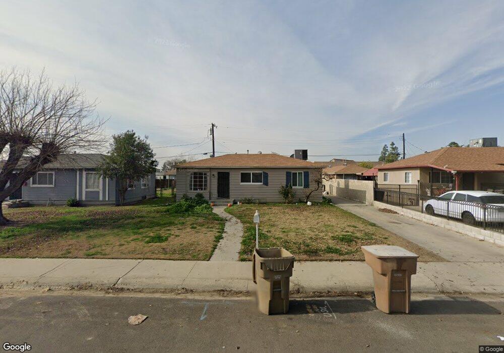
13 Jones St Bakersfield, CA 93309
Southwest Bakersfield NeighborhoodEstimated Value: $213,000 - $269,000
3
Beds
1
Bath
912
Sq Ft
$277/Sq Ft
Est. Value
About This Home
This home is located at 13 Jones St, Bakersfield, CA 93309 and is currently estimated at $252,622, approximately $276 per square foot. 13 Jones St is a home located in Kern County with nearby schools including Munsey Elementary School, Curran Middle School, and West High School.
Ownership History
Date
Name
Owned For
Owner Type
Purchase Details
Closed on
Jul 13, 2025
Sold by
Gutierrez Wuilfredo and Gutierrez Christina
Bought by
Wuilfredo And Christina Gutierrez 2024 Living
Current Estimated Value
Purchase Details
Closed on
Jul 19, 2020
Sold by
Maas Barlos
Bought by
Gutierrez Wuilfred and Gutierrez Christina
Purchase Details
Closed on
Nov 8, 2013
Sold by
Salinas Barbara
Bought by
Macias Carlos
Purchase Details
Closed on
Oct 24, 2005
Sold by
Monarrez Evita
Bought by
Salinas Barbara
Purchase Details
Closed on
Feb 15, 2005
Sold by
Aldana Arnulfo E and Aldana Diana L
Bought by
Monarrez Evita
Purchase Details
Closed on
Feb 11, 2005
Sold by
Pradan Inc
Bought by
Aldana Arnulfo E and Aldana Diana L
Purchase Details
Closed on
Feb 4, 2005
Sold by
Aldana Arnulfo E and Aldana Diana L
Bought by
Pradan Inc
Create a Home Valuation Report for This Property
The Home Valuation Report is an in-depth analysis detailing your home's value as well as a comparison with similar homes in the area
Home Values in the Area
Average Home Value in this Area
Purchase History
| Date | Buyer | Sale Price | Title Company |
|---|---|---|---|
| Wuilfredo And Christina Gutierrez 2024 Living | -- | None Listed On Document | |
| Gutierrez Wuilfred | -- | None Available | |
| Macias Carlos | $75,000 | Placer Title Company | |
| Salinas Barbara | -- | Commonwealth Land Title Co | |
| Monarrez Evita | -- | -- | |
| Aldana Arnulfo E | -- | -- | |
| Pradan Inc | $110,500 | -- |
Source: Public Records
Tax History Compared to Growth
Tax History
| Year | Tax Paid | Tax Assessment Tax Assessment Total Assessment is a certain percentage of the fair market value that is determined by local assessors to be the total taxable value of land and additions on the property. | Land | Improvement |
|---|---|---|---|---|
| 2025 | $2,634 | $178,600 | $43,296 | $135,304 |
| 2024 | $2,566 | $175,099 | $42,448 | $132,651 |
| 2023 | $2,566 | $171,666 | $41,616 | $130,050 |
| 2022 | $2,481 | $168,300 | $40,800 | $127,500 |
| 2021 | $1,427 | $84,931 | $22,647 | $62,284 |
| 2020 | $1,384 | $84,061 | $22,415 | $61,646 |
| 2019 | $1,357 | $84,061 | $22,415 | $61,646 |
| 2018 | $1,313 | $80,799 | $21,546 | $59,253 |
| 2017 | $1,302 | $79,216 | $21,124 | $58,092 |
| 2016 | $1,203 | $77,663 | $20,710 | $56,953 |
| 2015 | $1,202 | $76,497 | $20,399 | $56,098 |
| 2014 | $1,169 | $75,000 | $20,000 | $55,000 |
Source: Public Records
Map
Nearby Homes
- 7 Candy St
- 3800 Stockdale Hwy Unit 3
- 113 Griffiths St
- 113 N Stine Rd
- 3917 Stockdale Hwy
- 217 Garnsey Ave
- 305 Curran St
- 207 N Stine Rd
- 4500 Perris Way
- 3624 Elcia Dr
- 507 McDonald Way
- 512 McDonald Way
- 3820 Apache Ave
- 3920 Navajo Ave
- 4704 Stanton Way
- 198 Pelham Ct
- 615 Cherokee Dr
- 4101 La Mirada Dr
- 3720 Apache Ave
- 613 Middlefield St