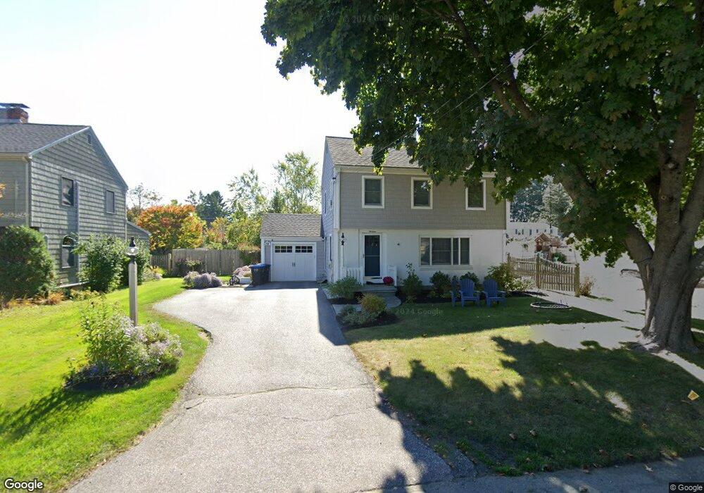
13 Phillips Rd Falmouth, ME 04105
Estimated Value: $841,000 - $1,042,496
3
Beds
2
Baths
1,910
Sq Ft
$490/Sq Ft
Est. Value
About This Home
This home is located at 13 Phillips Rd, Falmouth, ME 04105 and is currently estimated at $936,624, approximately $490 per square foot. 13 Phillips Rd is a home located in Cumberland County with nearby schools including Falmouth Middle School, Falmouth High School, and Baxter Academy for Tech & Sciences.
Ownership History
Date
Name
Owned For
Owner Type
Purchase Details
Closed on
Dec 20, 2017
Sold by
Brogan Cheryl M
Bought by
Maciag Eleanor B and Maciag Andrei R
Current Estimated Value
Home Financials for this Owner
Home Financials are based on the most recent Mortgage that was taken out on this home.
Original Mortgage
$215,000
Outstanding Balance
$180,824
Interest Rate
3.9%
Mortgage Type
Unknown
Estimated Equity
$755,800
Purchase Details
Closed on
Jan 17, 2007
Sold by
Hubbard Gunnar A and Winton Amy E
Bought by
Brogan Cheryl M
Home Financials for this Owner
Home Financials are based on the most recent Mortgage that was taken out on this home.
Original Mortgage
$319,200
Interest Rate
6.13%
Mortgage Type
Unknown
Purchase Details
Closed on
Jul 18, 2005
Sold by
Thurrell David L Est and Klebe
Bought by
Brogan Cheryl M
Create a Home Valuation Report for This Property
The Home Valuation Report is an in-depth analysis detailing your home's value as well as a comparison with similar homes in the area
Home Values in the Area
Average Home Value in this Area
Purchase History
| Date | Buyer | Sale Price | Title Company |
|---|---|---|---|
| Maciag Eleanor B | $425,000 | -- | |
| Maciag Eleanor B | $425,000 | -- | |
| Brogan Cheryl M | -- | -- | |
| Brogan Cheryl M | -- | -- | |
| Brogan Cheryl M | -- | -- | |
| Brogan Cheryl M | -- | -- |
Source: Public Records
Mortgage History
| Date | Status | Borrower | Loan Amount |
|---|---|---|---|
| Open | Maciag Eleanor B | $215,000 | |
| Closed | Maciag Eleanor B | $215,000 | |
| Previous Owner | Brogan Cheryl M | $202,000 | |
| Previous Owner | Brogan Cheryl M | $319,200 |
Source: Public Records
Tax History Compared to Growth
Tax History
| Year | Tax Paid | Tax Assessment Tax Assessment Total Assessment is a certain percentage of the fair market value that is determined by local assessors to be the total taxable value of land and additions on the property. | Land | Improvement |
|---|---|---|---|---|
| 2024 | $9,532 | $712,400 | $434,900 | $277,500 |
| 2023 | $8,990 | $711,200 | $434,900 | $276,300 |
| 2022 | $8,478 | $711,200 | $434,900 | $276,300 |
| 2021 | $6,181 | $354,600 | $190,500 | $164,100 |
| 2020 | $6,046 | $354,600 | $190,500 | $164,100 |
| 2019 | $5,982 | $354,600 | $190,500 | $164,100 |
| 2018 | $5,840 | $354,600 | $190,500 | $164,100 |
| 2017 | $9,276 | $354,600 | $190,500 | $164,100 |
| 2016 | $5,351 | $354,600 | $190,500 | $164,100 |
| 2015 | $5,188 | $354,600 | $190,500 | $164,100 |
| 2014 | $4,859 | $354,600 | $190,500 | $164,100 |
| 2012 | -- | $352,800 | $190,500 | $162,300 |
Source: Public Records
Map
Nearby Homes
- 5 Cobblestone St Unit 53
- 6 Tidewater Cove
- 9-11 Bismark St
- 242 Veranda St
- 27 Colonial Village
- 45 Middle Rd
- 53 Waites Landing Rd
- 62 Waites Landing Rd
- 11 Osprey Terrace
- 38 Wellstone Dr
- 118 Providence St
- 75 Clearwater Dr Unit 305
- 57 Foreside Rd
- 24 Oakland Rd
- 54-56 Veranda St
- 56 Saint Jude St
- 259 Sherwood St
- Lot 1 Acadia Dr
- 26 Presumpscot St
- 593 Washington Ave