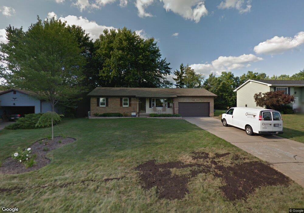
130 Carter Cir Youngstown, OH 44512
Estimated Value: $192,000 - $199,000
3
Beds
1
Bath
1,164
Sq Ft
$169/Sq Ft
Est. Value
About This Home
This home is located at 130 Carter Cir, Youngstown, OH 44512 and is currently estimated at $196,495, approximately $168 per square foot. 130 Carter Cir is a home located in Mahoning County with nearby schools including Stadium Drive Elementary School, Boardman Center Middle School, and Boardman High School.
Ownership History
Date
Name
Owned For
Owner Type
Purchase Details
Closed on
Mar 17, 2009
Sold by
Bank Of America National Association
Bought by
Patton Burl W
Current Estimated Value
Home Financials for this Owner
Home Financials are based on the most recent Mortgage that was taken out on this home.
Original Mortgage
$56,700
Outstanding Balance
$36,015
Interest Rate
5.11%
Mortgage Type
New Conventional
Estimated Equity
$160,480
Purchase Details
Closed on
Dec 1, 2008
Sold by
Kotheimer Deborah A
Bought by
Lasalle Bank National Association
Purchase Details
Closed on
Jul 23, 1979
Bought by
Kotheimer Frederick M and Kotheimer D
Create a Home Valuation Report for This Property
The Home Valuation Report is an in-depth analysis detailing your home's value as well as a comparison with similar homes in the area
Home Values in the Area
Average Home Value in this Area
Purchase History
| Date | Buyer | Sale Price | Title Company |
|---|---|---|---|
| Patton Burl W | $63,000 | Attorney | |
| Lasalle Bank National Association | $66,000 | None Available | |
| Kotheimer Frederick M | -- | -- |
Source: Public Records
Mortgage History
| Date | Status | Borrower | Loan Amount |
|---|---|---|---|
| Open | Patton Burl W | $56,700 |
Source: Public Records
Tax History Compared to Growth
Tax History
| Year | Tax Paid | Tax Assessment Tax Assessment Total Assessment is a certain percentage of the fair market value that is determined by local assessors to be the total taxable value of land and additions on the property. | Land | Improvement |
|---|---|---|---|---|
| 2024 | $2,723 | $52,930 | $9,790 | $43,140 |
| 2023 | $2,687 | $52,930 | $9,790 | $43,140 |
| 2022 | $2,856 | $43,140 | $9,790 | $33,350 |
| 2021 | $2,858 | $43,140 | $9,790 | $33,350 |
| 2020 | $2,873 | $43,140 | $9,790 | $33,350 |
| 2019 | $2,603 | $34,240 | $7,770 | $26,470 |
| 2018 | $2,226 | $33,910 | $7,770 | $26,140 |
| 2017 | $2,185 | $33,910 | $7,770 | $26,140 |
| 2016 | $1,939 | $29,720 | $7,770 | $21,950 |
| 2015 | $1,901 | $29,720 | $7,770 | $21,950 |
| 2014 | $1,906 | $29,720 | $7,770 | $21,950 |
| 2013 | $1,882 | $29,720 | $7,770 | $21,950 |
Source: Public Records
Map
Nearby Homes
- 74 Carter Cir
- 153 Creston Dr
- 0 W Western Reserve Rd Unit 5146459
- 8502 Glenwood Ave
- 9144 Sharrott Rd
- 8218 Maramont Dr Unit B
- 470 Garver Dr
- 235 E Western Reserve Rd
- 9264 Sharrott Rd Unit 1004
- 9264 Sharrott Rd Unit 1001
- 9264 Sharrott Rd Unit 104
- 9264 Sharrott Rd Unit 1002
- Rosewood Plan at Courtyards at Stonegate
- 123 Mayflower Dr
- 134 Mayflower Dr
- 331 Warren Ave
- 1555 W Western Reserve Rd
- 150 Cedars Dr
- 363 Maple Dr
- 0 Harvard Rd Unit 5038029
- 126 Carter Cir
- 134 Carter Cir
- 138 Carter Cir
- 122 Carter Cir
- 131 Carter Cir
- 157 Lost Creek Dr
- 127 Carter Cir
- 135 Carter Cir
- 142 Carter Cir
- 123 Carter Cir
- 139 Carter Cir
- 118 Carter Cir
- 153 Lost Creek Dr
- 146 Carter Cir
- 143 Carter Cir
- 132 Runnemede Dr
- 8450 Market St
- 128 Runnemede Dr
- 136 Runnemede Dr
- 149 Lost Creek Dr