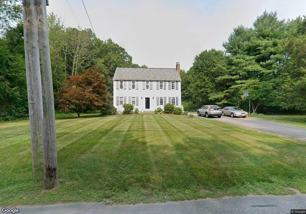
130 Jewell St Mansfield, MA 02048
Estimated Value: $679,268 - $754,000
4
Beds
2
Baths
1,728
Sq Ft
$421/Sq Ft
Est. Value
About This Home
This home is located at 130 Jewell St, Mansfield, MA 02048 and is currently estimated at $727,567, approximately $421 per square foot. 130 Jewell St is a home located in Bristol County with nearby schools including Everett W. Robinson Elementary School, Jordan/Jackson Elementary School, and Harold L. Qualters Middle School.
Ownership History
Date
Name
Owned For
Owner Type
Purchase Details
Closed on
Mar 7, 2023
Sold by
Romanko William P and Romanko Sheila M
Bought by
Romanko Ft
Current Estimated Value
Purchase Details
Closed on
Nov 13, 1987
Sold by
Tessier Norman O
Bought by
Staple Richard L
Home Financials for this Owner
Home Financials are based on the most recent Mortgage that was taken out on this home.
Original Mortgage
$116,000
Interest Rate
11.13%
Mortgage Type
Purchase Money Mortgage
Create a Home Valuation Report for This Property
The Home Valuation Report is an in-depth analysis detailing your home's value as well as a comparison with similar homes in the area
Home Values in the Area
Average Home Value in this Area
Purchase History
| Date | Buyer | Sale Price | Title Company |
|---|---|---|---|
| Romanko Ft | -- | None Available | |
| Staple Richard L | $145,000 | -- |
Source: Public Records
Mortgage History
| Date | Status | Borrower | Loan Amount |
|---|---|---|---|
| Previous Owner | Staple Richard L | $99,000 | |
| Previous Owner | Staple Richard L | $110,000 | |
| Previous Owner | Staple Richard L | $15,000 | |
| Previous Owner | Staple Richard L | $116,000 |
Source: Public Records
Tax History Compared to Growth
Tax History
| Year | Tax Paid | Tax Assessment Tax Assessment Total Assessment is a certain percentage of the fair market value that is determined by local assessors to be the total taxable value of land and additions on the property. | Land | Improvement |
|---|---|---|---|---|
| 2025 | $7,380 | $560,400 | $241,900 | $318,500 |
| 2024 | $7,231 | $535,600 | $241,900 | $293,700 |
| 2023 | $7,024 | $498,500 | $241,900 | $256,600 |
| 2022 | $6,760 | $445,600 | $223,900 | $221,700 |
| 2021 | $6,657 | $433,400 | $196,000 | $237,400 |
| 2020 | $6,419 | $417,900 | $186,700 | $231,200 |
| 2019 | $5,918 | $388,800 | $155,500 | $233,300 |
| 2018 | $5,621 | $377,400 | $148,300 | $229,100 |
| 2017 | $5,511 | $366,900 | $144,100 | $222,800 |
| 2016 | $5,290 | $343,300 | $137,200 | $206,100 |
| 2015 | $5,158 | $332,800 | $137,200 | $195,600 |
Source: Public Records
Map
Nearby Homes
- 4 Buckskin Dr
- 150 Gilbert St
- 24 Maverick Dr
- 176 Elm St
- 255 Mckeon Dr
- 2 Oak St Unit 2D
- 2 Oak St Unit 2A
- 2 Oak St Unit 2C
- 2 Oak St Unit 2B
- 451R Gilbert St
- 37 Oakleaf Dr
- 196 Donald Tennant Cir
- 450 West St
- 11 Landry Ave
- 231 Spring St
- 115 Westfield Dr
- 116 George St
- 406 South St
- 11 Buckthorn Ln
- 57 Vine St