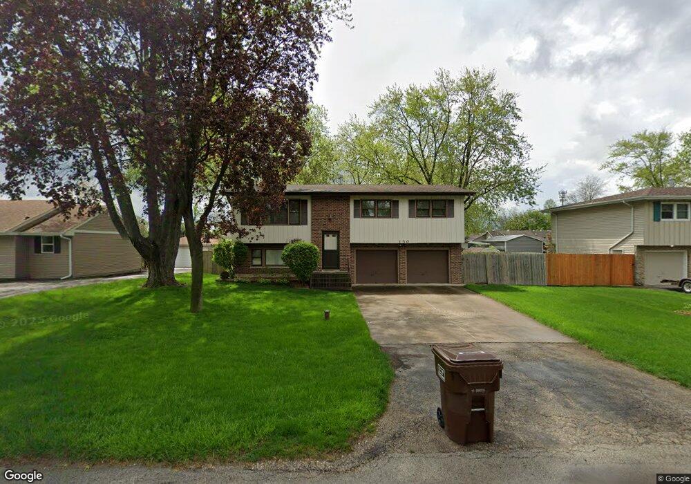
130 Michael Ln New Lenox, IL 60451
Estimated Value: $247,764 - $329,000
Studio
--
Bath
--
Sq Ft
10,019
Sq Ft Lot
About This Home
This home is located at 130 Michael Ln, New Lenox, IL 60451 and is currently estimated at $298,191. 130 Michael Ln is a home located in Will County with nearby schools including Oster-Oakview School, Haines Elementary School, and Lincoln Way West.
Ownership History
Date
Name
Owned For
Owner Type
Purchase Details
Closed on
Feb 18, 2023
Sold by
Strom Bernadette N
Bought by
Bernadette N Strom Living Trust
Current Estimated Value
Purchase Details
Closed on
Aug 27, 2001
Sold by
Conwell Charmain C
Bought by
Strom Bernadette N
Purchase Details
Closed on
Apr 1, 1996
Sold by
Hiller John J and Hiller Terese M
Bought by
Strom Bernadette N and Conwell Charmain C
Home Financials for this Owner
Home Financials are based on the most recent Mortgage that was taken out on this home.
Original Mortgage
$125,050
Interest Rate
7.86%
Create a Home Valuation Report for This Property
The Home Valuation Report is an in-depth analysis detailing your home's value as well as a comparison with similar homes in the area
Home Values in the Area
Average Home Value in this Area
Purchase History
| Date | Buyer | Sale Price | Title Company |
|---|---|---|---|
| Bernadette N Strom Living Trust | -- | -- | |
| Strom Bernadette N | -- | -- | |
| Strom Bernadette N | $135,000 | -- |
Source: Public Records
Mortgage History
| Date | Status | Borrower | Loan Amount |
|---|---|---|---|
| Previous Owner | Strom Bernadette N | $125,050 |
Source: Public Records
Tax History
| Year | Tax Paid | Tax Assessment Tax Assessment Total Assessment is a certain percentage of the fair market value that is determined by local assessors to be the total taxable value of land and additions on the property. | Land | Improvement |
|---|---|---|---|---|
| 2024 | $6,106 | $86,044 | $20,237 | $65,807 |
| 2023 | $6,106 | $78,436 | $18,448 | $59,988 |
| 2022 | $5,527 | $72,258 | $16,995 | $55,263 |
| 2021 | $5,236 | $67,956 | $15,983 | $51,973 |
| 2020 | $5,078 | $65,532 | $15,413 | $50,119 |
| 2019 | $4,851 | $63,500 | $14,935 | $48,565 |
| 2018 | $4,731 | $61,311 | $14,420 | $46,891 |
| 2017 | $4,484 | $59,548 | $14,005 | $45,543 |
| 2016 | $4,347 | $57,954 | $13,630 | $44,324 |
| 2015 | $4,174 | $56,130 | $13,201 | $42,929 |
| 2014 | $4,174 | $55,437 | $13,038 | $42,399 |
| 2013 | $4,174 | $56,185 | $13,214 | $42,971 |
Source: Public Records
Map
Nearby Homes
- Lot 207 N Cedar Rd
- 0 N Cedar Rd
- 347 W Francis Rd Unit 1
- 12001 W Route 6
- 1999 Silver Cross Blvd
- 209 Linden Oaks Ln
- 0 Silver Cross Blvd
- 1301 Silver Cross Blvd
- 830 Wagon Dr
- 1605 S Regan Rd
- 1502 London Rd
- 13621 W Maple Rd
- 13741 Elizabeth Ln
- 326 Old Hickory Rd
- 914 Somerset Acres
- 380 N Cedar Rd
- Vacant W Maple St
- 1110 Lakeside Dr
- 3409 Norwood Ln
- 211 Manor Dr Unit 1
- 124 Michael Ln
- 134 Michael Ln
- 127 Branchaw Blvd
- 123 Branchaw Blvd
- 122 Michael Ln
- 138 Michael Ln
- 131 Branchaw Blvd
- 129 Michael Ln
- 125 Michael Ln
- 133 Michael Ln
- 118 Michael Ln
- 142 Michael Ln
- 121 Michael Ln
- 121 Michael Ln
- 137 Michael Ln
- 135 Branchaw Blvd
- 117 Michael Ln
- 114 Michael Ln
- 141 Michael Ln
- 146 Michael Ln
Your Personal Tour Guide
Ask me questions while you tour the home.