130 Millstone Rd Unit 12 Brewster, MA 02631
Estimated payment $2,966/month
Highlights
- Golf Course Community
- Medical Services
- Wood Flooring
- Nauset Regional High School Rated A
- Property is near public transit
- Community Pool
About This Home
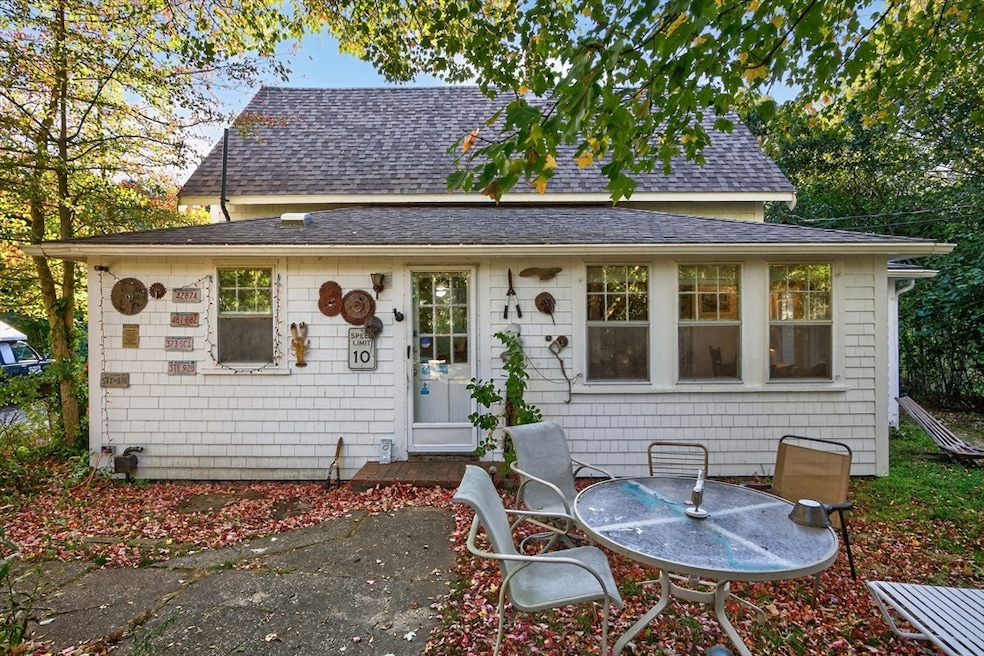
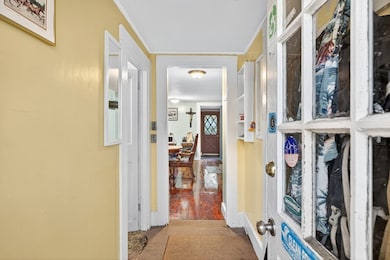
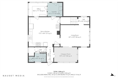
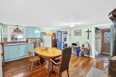
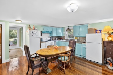
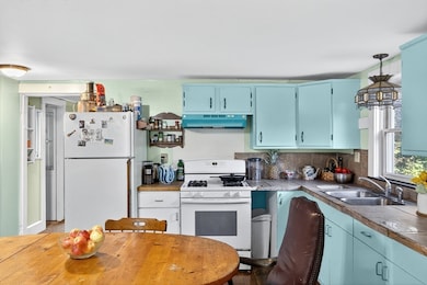
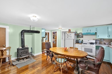
Motivated seller. This three-bedroom, one-bath home offers the best of both worlds in Brewster's Bayside Cottages. Set apart with its own private driveway and half-acre exclusive-use area, this stand-alone cottage enjoys privacy while benefitting from the conveniences of condo living. Recent updates include roof and siding. The first floor features forced hot air heat; note there is no heat on the second floor, making it a candidate for a heat pump system. The home is being sold as is, and pricing reflects this. Offering an exceptional opportunity for ownership in Brewster's bayside, this property represents one of the best stand-alone values in town—ideal for a creative buyer ready to make it their own. Access to First Light Beach, the bike trail, and new Millstone sidewalks provide easy connection to all that Brewster has to offer. Buyer to perform due diligence and verify all information contained herein. OH CANCELED 11/1/25.
Property Details
Home Type
- Condominium
Est. Annual Taxes
- $3,388
Year Built
- Built in 1940
HOA Fees
- $455 Monthly HOA Fees
Parking
- 4 Car Parking Spaces
Home Design
- Entry on the 1st floor
- Frame Construction
- Shingle Roof
- Wood Roof
Interior Spaces
- 1,351 Sq Ft Home
- 1-Story Property
- Range
Flooring
- Wood
- Vinyl
Bedrooms and Bathrooms
- 3 Bedrooms
- Primary bedroom located on second floor
- 1 Full Bathroom
Laundry
- Laundry on main level
- Dryer
- Washer
Outdoor Features
- Walking Distance to Water
Location
- Property is near public transit
- Property is near schools
Schools
- Eddy/Stonybrook Elementary School
- NRMS Middle School
- Nauset High School
Utilities
- No Cooling
- Forced Air Heating System
- 1 Heating Zone
- Heating System Uses Oil
- Sewer Inspection Required for Sale
Listing and Financial Details
- Assessor Parcel Number 1011913898,5257308
Community Details
Overview
- Association fees include sewer, insurance, maintenance structure, snow removal, trash
- 12 Units
- Near Conservation Area
Amenities
- Medical Services
- Community Garden
- Shops
- Coin Laundry
- Community Storage Space
Recreation
- Golf Course Community
- Community Pool
- Park
- Jogging Path
- Trails
- Bike Trail
Map
Home Values in the Area
Average Home Value in this Area
Tax History
| Year | Tax Paid | Tax Assessment Tax Assessment Total Assessment is a certain percentage of the fair market value that is determined by local assessors to be the total taxable value of land and additions on the property. | Land | Improvement |
|---|---|---|---|---|
| 2025 | $3,214 | $467,100 | $0 | $467,100 |
| 2024 | $3,003 | $440,900 | $0 | $440,900 |
| 2023 | $3,235 | $462,800 | $0 | $462,800 |
| 2022 | $2,911 | $370,800 | $0 | $370,800 |
| 2021 | $2,573 | $299,900 | $0 | $299,900 |
| 2020 | $2,406 | $279,100 | $0 | $279,100 |
| 2019 | $2,328 | $271,300 | $0 | $271,300 |
| 2018 | $2,043 | $247,300 | $0 | $247,300 |
| 2017 | $1,631 | $194,400 | $0 | $194,400 |
| 2016 | $1,607 | $190,600 | $0 | $190,600 |
| 2015 | $1,536 | $186,000 | $0 | $186,000 |
Property History
| Date | Event | Price | List to Sale | Price per Sq Ft |
|---|---|---|---|---|
| 12/05/2025 12/05/25 | Price Changed | $425,000 | -5.6% | $315 / Sq Ft |
| 10/30/2025 10/30/25 | Price Changed | $450,000 | -9.1% | $333 / Sq Ft |
| 10/14/2025 10/14/25 | For Sale | $495,000 | -- | $366 / Sq Ft |
Purchase History
| Date | Type | Sale Price | Title Company |
|---|---|---|---|
| Deed | $212,500 | -- | |
| Deed | -- | -- | |
| Deed | $531,000 | -- |
Mortgage History
| Date | Status | Loan Amount | Loan Type |
|---|---|---|---|
| Open | $191,250 | Purchase Money Mortgage | |
| Previous Owner | $250,000 | Purchase Money Mortgage |
Source: MLS Property Information Network (MLS PIN)
MLS Number: 73443252
APN: BREW-000101-000019-013898
Disclaimer: Certain information contained herein is derived from information provided by parties other than Homes.com. All information provided is deemed reliable, but is not guaranteed to be accurate and should be independently verified.
![]() The property listing data and information, or the Images, set forth herein were provided to MLS Property Information Network, Inc. from third party sources, including sellers, lessors and public records, and were compiled by MLS Property Information Network, Inc. The property listing data and information, and the Images, are for the personal, non-commercial use of consumers having a good faith interest in purchasing or leasing listed properties of the type displayed to them and may not be used for any purpose other than to identify prospective properties which such consumers may have a good faith interest in purchasing or leasing. MLS Property Information Network, Inc. and its subscribers disclaim any and all representations and warranties as to the accuracy of the property listing data and information, or as to the accuracy of any of the Images, set forth herein.
The property listing data and information, or the Images, set forth herein were provided to MLS Property Information Network, Inc. from third party sources, including sellers, lessors and public records, and were compiled by MLS Property Information Network, Inc. The property listing data and information, and the Images, are for the personal, non-commercial use of consumers having a good faith interest in purchasing or leasing listed properties of the type displayed to them and may not be used for any purpose other than to identify prospective properties which such consumers may have a good faith interest in purchasing or leasing. MLS Property Information Network, Inc. and its subscribers disclaim any and all representations and warranties as to the accuracy of the property listing data and information, or as to the accuracy of any of the Images, set forth herein.
- 410 Blueberry Pond Dr
- 26 Pinewood Dr
- 398 Lund Farm Way
- 277 Lund Farm Way
- 104 Howland Cir Unit 104
- 28 Middlecott Ln
- 82 Middlecott Ln
- 100 Fletcher Ln Unit E
- 60 Fletcher Ln Unit H
- 60 Fletcher Ln Unit C
- 23 Landing Ln Unit 23
- 261 Linnell Landing Rd Unit 2
- 42 Landing Ln Unit 42
- 82 Fletcher Ln Unit I
- 104 Sachemus Trail Unit 104
- 46 Court Way
- 765 Millstone Rd
- 52 Eaton Ln Unit (52)
- 0 Commons Way Unit 22504099
- 5 Commons Way
- 19 West Rd
- 873 Harwich Rd
- 80 Cranberry Hwy Unit 1
- 12 Seavers Rd
- 101 Monomoyic Way
- 26 Cranwood Rd
- 175 Sam Ryder Rd
- 328 Bank St
- 328 Bank St Unit 4
- 328 Bank St Unit 5
- 328 Bank St Unit 21
- 328 Bank St Unit 1
- 181 George Ryder Rd
- 6 Ruth Ln
- 41 Bank St Unit 13
- 141 Division St Unit 4
- 5 Elwood Rd
- 20 Trumet Rd
- 576 Main St Unit 3
