
Seller's Agent in 2025
Carol Perry
Sun Realty - KDH
(252) 207-5554
24 in this area
47 Total Sales


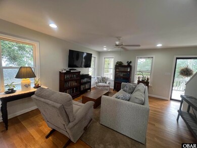
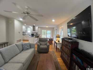
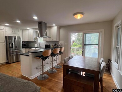
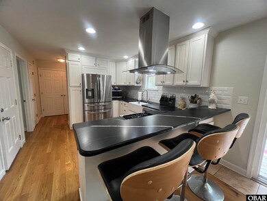
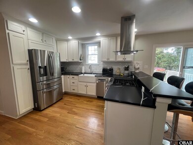
Charming Cape Cod Retreat w/IN-LAW-SUITE/4th Bedroom in Colington Harbour! Discover this well-built quality, 3 BD, 3 BA, Cape Cod style gem with a versatile ground-level In-Law Suite/4th bedroom, perfect for multi-generational living, guests complete with it own full bath and LVP flooring for easy maintenance. 2018. Private entrance and interior stairs. Step onto the large inviting covered front porch-ideal for morning coffee or evening unwinding- then enter to gleaming hardwood floors that flow through the living areas. Lovely, updated kitchen with quartz countertops, tile back splash, stainless appliances with ample cabinetry - 2021. The expansive primary suite upstairs includes a walk-in closet, spa-inspired bath w/tile finishes. Newly replaced front and back decks perfect for BBQs or relaxing. Enjoy peace of mind with a high-elevation site, Zone X. Lovely canal views across the street!! An outdoor shed provides extra storage for tools and gear. This is a must see! The seller may require a short lease back.
Last Agent to Sell the Property
Sun Realty - KDH Brokerage Phone: 252-441-8011 License #204144 Listed on: 10/16/2025
| Date | Type | Sale Price | Title Company |
|---|---|---|---|
| Warranty Deed | $450,000 | None Listed On Document | |
| Warranty Deed | -- | None Available | |
| Warranty Deed | $118,000 | Chicago Title Insurance Comp |
| Date | Status | Loan Amount | Loan Type |
|---|---|---|---|
| Open | $366,300 | FHA | |
| Previous Owner | $208,000 | New Conventional | |
| Previous Owner | $260,000 | Construction |
| Date | Event | Price | List to Sale | Price per Sq Ft |
|---|---|---|---|---|
| 12/16/2025 12/16/25 | Sold | $450,000 | +0.1% | $321 / Sq Ft |
| 10/17/2025 10/17/25 | Pending | -- | -- | -- |
| 10/16/2025 10/16/25 | For Sale | $449,500 | -- | $321 / Sq Ft |
| Year | Tax Paid | Tax Assessment Tax Assessment Total Assessment is a certain percentage of the fair market value that is determined by local assessors to be the total taxable value of land and additions on the property. | Land | Improvement |
|---|---|---|---|---|
| 2025 | $1,705 | $391,500 | $84,800 | $306,700 |
| 2024 | $1,728 | $276,400 | $44,100 | $232,300 |
| 2023 | $1,728 | $276,400 | $44,100 | $232,300 |
| 2022 | $1,700 | $276,400 | $44,100 | $232,300 |
| 2021 | $1,672 | $276,400 | $44,100 | $232,300 |
| 2020 | $1,387 | $276,400 | $44,100 | $232,300 |
| 2019 | $1,387 | $194,800 | $39,300 | $155,500 |
| 2018 | $1,387 | $194,800 | $39,300 | $155,500 |
| 2017 | $1,387 | $194,800 | $39,300 | $155,500 |
| 2016 | $1,309 | $194,800 | $39,300 | $155,500 |
| 2014 | $1,270 | $194,800 | $39,300 | $155,500 |
Seller's Agent in 2025
Carol Perry
Sun Realty - KDH
(252) 207-5554
24 in this area
47 Total Sales
Buyer's Agent in 2025
Michelle Gardner
Resort Realty - NH
(252) 715-1911
13 in this area
37 Total Sales
Source: Outer Banks Association of REALTORS®
MLS Number: 130782
APN: 019031000
Disclaimer: Certain information contained herein is derived from information provided by parties other than Homes.com. All information provided is deemed reliable, but is not guaranteed to be accurate and should be independently verified.
![]() IDX information is provided exclusively for personal, non-commercial use, and may not be used for any purpose other than to identify prospective properties consumers may be interested in purchasing.
IDX information is provided exclusively for personal, non-commercial use, and may not be used for any purpose other than to identify prospective properties consumers may be interested in purchasing.
Information is deemed reliable but not guaranteed.
Ask me questions while you tour the home.