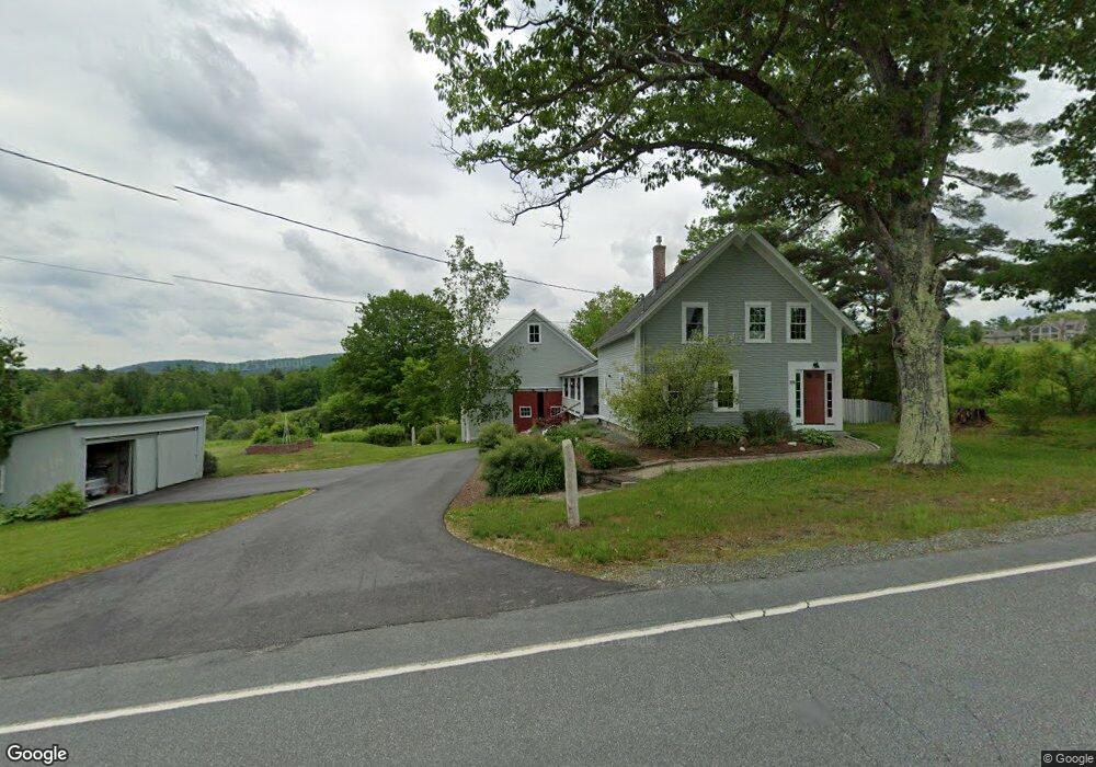
130 Sutton Rd New London, NH 03257
Estimated Value: $441,000 - $650,000
2
Beds
2
Baths
1,568
Sq Ft
$338/Sq Ft
Est. Value
About This Home
This home is located at 130 Sutton Rd, New London, NH 03257 and is currently estimated at $529,883, approximately $337 per square foot. 130 Sutton Rd is a home located in Merrimack County with nearby schools including Kearsarge Elementary School - New London, Kearsarge Regional Middle School, and Kearsarge Regional High School.
Ownership History
Date
Name
Owned For
Owner Type
Purchase Details
Closed on
Aug 23, 2010
Sold by
Messer Geraldine E Est
Bought by
Wheeler Ilene and Blake Jeffrey
Current Estimated Value
Home Financials for this Owner
Home Financials are based on the most recent Mortgage that was taken out on this home.
Original Mortgage
$216,000
Outstanding Balance
$143,445
Interest Rate
4.63%
Mortgage Type
Purchase Money Mortgage
Estimated Equity
$386,438
Create a Home Valuation Report for This Property
The Home Valuation Report is an in-depth analysis detailing your home's value as well as a comparison with similar homes in the area
Home Values in the Area
Average Home Value in this Area
Purchase History
| Date | Buyer | Sale Price | Title Company |
|---|---|---|---|
| Wheeler Ilene | $158,000 | -- |
Source: Public Records
Mortgage History
| Date | Status | Borrower | Loan Amount |
|---|---|---|---|
| Open | Wheeler Ilene | $216,000 |
Source: Public Records
Tax History Compared to Growth
Tax History
| Year | Tax Paid | Tax Assessment Tax Assessment Total Assessment is a certain percentage of the fair market value that is determined by local assessors to be the total taxable value of land and additions on the property. | Land | Improvement |
|---|---|---|---|---|
| 2024 | $4,337 | $373,600 | $167,500 | $206,100 |
| 2023 | $4,039 | $373,600 | $167,500 | $206,100 |
| 2022 | $3,746 | $236,200 | $88,900 | $147,300 |
| 2021 | $3,635 | $236,200 | $88,900 | $147,300 |
| 2020 | $3,529 | $236,200 | $88,900 | $147,300 |
| 2019 | $3,475 | $236,200 | $88,900 | $147,300 |
| 2018 | $3,594 | $228,800 | $105,700 | $123,100 |
| 2017 | $3,663 | $228,800 | $105,700 | $123,100 |
| 2016 | $3,342 | $213,300 | $105,700 | $107,600 |
| 2015 | $3,411 | $220,800 | $105,700 | $115,100 |
| 2014 | $3,380 | $220,800 | $105,700 | $115,100 |
| 2013 | $3,675 | $244,200 | $105,700 | $138,500 |
Source: Public Records
Map
Nearby Homes
- 0 Fairway Ln Unit 8
- 295 Andover Rd
- 158 Quail Run
- 000 Shaker Rd Unit 288
- 155 Wilder Ln
- 00 Mountainside Dr Unit 183
- 385 Seamans Rd
- 58 Kearsarge Rd
- 27 Pipers Glen
- 0 Summit Rd Unit 431
- 555 Shaker Rd
- 65 Barrett Rd
- 24 Mountain Overlook
- 0 Quiet Cove Way Unit 5
- 106-23 Fieldstone Ln
- 273 Forest Acres Rd
- 0 Newport Rd Unit 10
- 10 Highland Ridge Rd
- 712 Sugarhouse Rd
- 195 Pine Hill Rd
- 146 Sutton Rd
- 105 Sutton Rd
- 181 Sutton Rd
- 95 Rowell Hill Rd
- 127 Sutton Rd
- 79 Sutton Rd
- 143 Rowell Hill Rd
- 205 Sutton Rd
- 53 Overlook Terrace
- 51 Rowell Hill Rd
- 67 Sutton Rd
- 223 Sutton Rd
- 74 Little Britton Ln
- 11 Ridge Rd
- 11 Ridge Rd Unit 11
- 18 Sutton Rd
- 40 Andover Rd
- 37 Overlook Terrace
- 237 Sutton Rd
- 50 Rowell Hill Rd