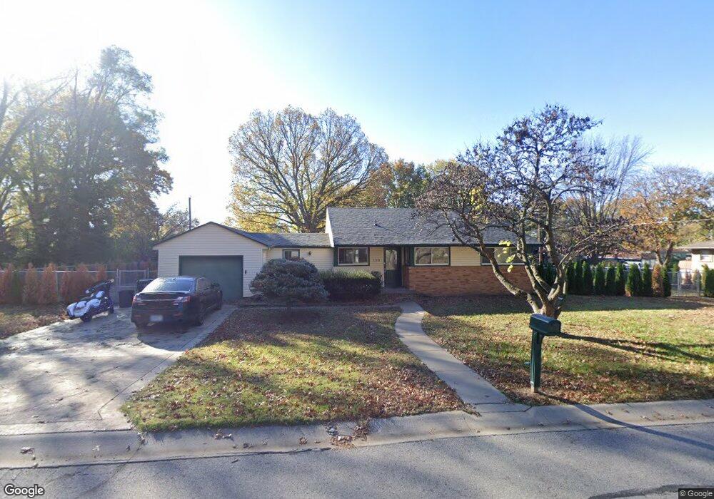
130 Woodland St Lansing, KS 66043
Estimated Value: $218,000 - $236,619
3
Beds
2
Baths
1,780
Sq Ft
$127/Sq Ft
Est. Value
About This Home
This home is located at 130 Woodland St, Lansing, KS 66043 and is currently estimated at $226,655, approximately $127 per square foot. 130 Woodland St is a home located in Leavenworth County with nearby schools including Lansing Elementary School, Lansing Middle 6-8, and Lansing High 9-12.
Ownership History
Date
Name
Owned For
Owner Type
Purchase Details
Closed on
Apr 8, 2023
Sold by
Patricia G Long Declaration Of Trust
Bought by
Long Dallas L
Current Estimated Value
Purchase Details
Closed on
Sep 1, 1996
Bought by
Long Patricia G
Home Financials for this Owner
Home Financials are based on the most recent Mortgage that was taken out on this home.
Original Mortgage
$64,000
Interest Rate
7.6%
Mortgage Type
New Conventional
Create a Home Valuation Report for This Property
The Home Valuation Report is an in-depth analysis detailing your home's value as well as a comparison with similar homes in the area
Home Values in the Area
Average Home Value in this Area
Purchase History
| Date | Buyer | Sale Price | Title Company |
|---|---|---|---|
| Long Dallas L | -- | None Listed On Document | |
| Long Patricia G | $77,500 | -- |
Source: Public Records
Mortgage History
| Date | Status | Borrower | Loan Amount |
|---|---|---|---|
| Previous Owner | Long Patricia G | $64,000 |
Source: Public Records
Tax History Compared to Growth
Tax History
| Year | Tax Paid | Tax Assessment Tax Assessment Total Assessment is a certain percentage of the fair market value that is determined by local assessors to be the total taxable value of land and additions on the property. | Land | Improvement |
|---|---|---|---|---|
| 2025 | $2,539 | $20,849 | $5,058 | $15,791 |
| 2024 | $2,387 | $19,485 | $4,069 | $15,416 |
| 2023 | $2,387 | $18,735 | $4,069 | $14,666 |
| 2022 | $2,295 | $17,031 | $3,238 | $13,793 |
| 2021 | $2,283 | $16,008 | $3,238 | $12,770 |
| 2020 | $2,243 | $15,479 | $3,344 | $12,135 |
| 2019 | $2,115 | $14,590 | $3,344 | $11,246 |
| 2018 | $1,944 | $13,443 | $2,747 | $10,696 |
| 2017 | $1,949 | $13,443 | $2,747 | $10,696 |
| 2016 | $1,918 | $13,234 | $2,747 | $10,487 |
| 2015 | -- | $13,234 | $2,747 | $10,487 |
| 2014 | -- | $12,911 | $2,747 | $10,164 |
Source: Public Records
Map
Nearby Homes
- 268 Holiday Dr
- 415 Fairlane St
- 129 Brookwood St
- 1102 N Main St
- 4 Eisenhower Rd
- 218 Oak Hill St
- 129 Crestview Ct
- 1100 N 4th St
- 1102 N 4th St
- 542 Creekside Ct
- 20958 Ida St
- 610 Meadowlark Rd
- 603 E Beth St
- 601 E Eisenhower Rd
- 124 S Main St
- 202 S Main St
- 728 Eisenhower Rd
- 218 E Kay St
- 4915 Parkway Dr
- 306 E Kay St