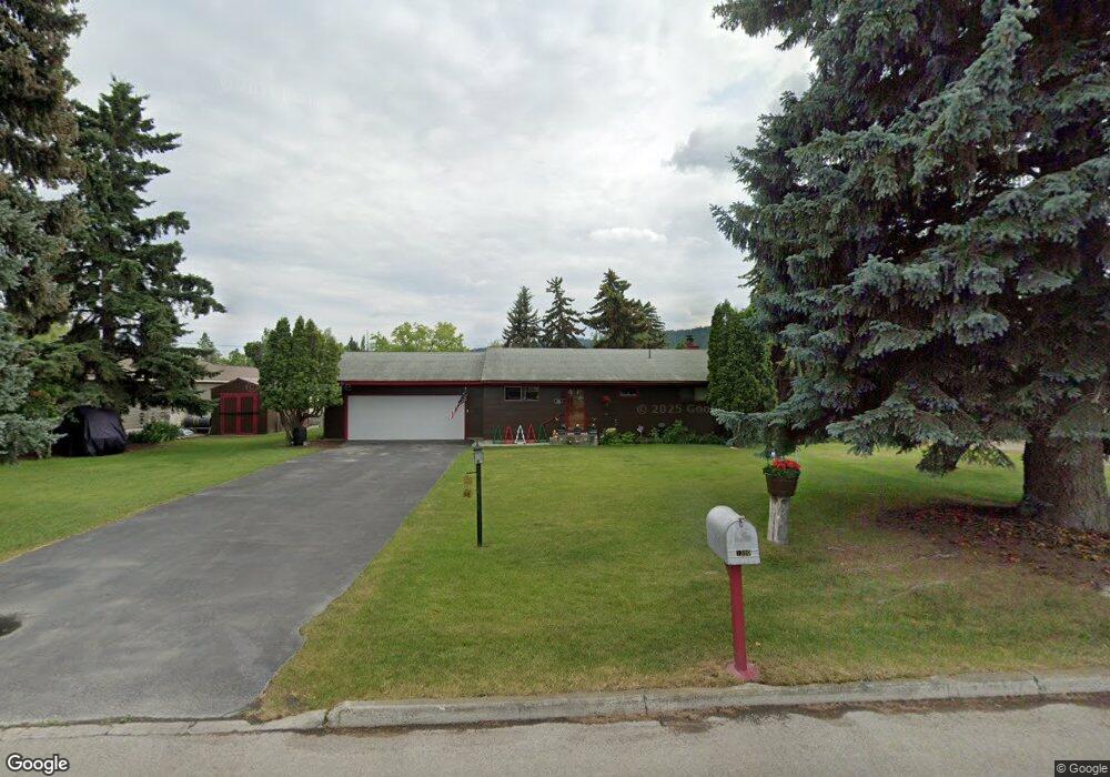
1300 2nd St W Kalispell, MT 59901
Estimated Value: $230,000 - $417,000
2
Beds
1
Bath
1,008
Sq Ft
$347/Sq Ft
Est. Value
About This Home
This home is located at 1300 2nd St W, Kalispell, MT 59901 and is currently estimated at $350,233, approximately $347 per square foot. 1300 2nd St W is a home located in Flathead County with nearby schools including Lillian Peterson School, Kalispell Middle School, and Flathead High School.
Ownership History
Date
Name
Owned For
Owner Type
Purchase Details
Closed on
May 12, 2010
Sold by
Perzinski Virginia P and Perzinski Robert P
Bought by
Holmes John M and Holmes Deeanna Sue
Current Estimated Value
Home Financials for this Owner
Home Financials are based on the most recent Mortgage that was taken out on this home.
Original Mortgage
$119,516
Interest Rate
5.04%
Mortgage Type
Purchase Money Mortgage
Purchase Details
Closed on
Oct 15, 2009
Sold by
Perzinski Virginia P
Bought by
Perzinski Virginia P and Perzinski Robert R
Purchase Details
Closed on
Oct 9, 2009
Sold by
Olson Gerald M
Bought by
Perzinski Virginia P
Purchase Details
Closed on
Oct 8, 2009
Sold by
Odonnell Carole M
Bought by
Perzinski Virginia P
Purchase Details
Closed on
Oct 6, 2009
Sold by
Perzinski Virginia P and Estate Of Irene Alice Olson
Bought by
Olson Gerald M and Odonnell Carole M
Create a Home Valuation Report for This Property
The Home Valuation Report is an in-depth analysis detailing your home's value as well as a comparison with similar homes in the area
Home Values in the Area
Average Home Value in this Area
Purchase History
| Date | Buyer | Sale Price | Title Company |
|---|---|---|---|
| Holmes John M | -- | Insured Titles | |
| Perzinski Virginia P | -- | None Available | |
| Perzinski Virginia P | -- | None Available | |
| Perzinski Virginia P | -- | None Available | |
| Olson Gerald M | -- | None Available |
Source: Public Records
Mortgage History
| Date | Status | Borrower | Loan Amount |
|---|---|---|---|
| Open | Holmes John M | $119,516 |
Source: Public Records
Tax History Compared to Growth
Tax History
| Year | Tax Paid | Tax Assessment Tax Assessment Total Assessment is a certain percentage of the fair market value that is determined by local assessors to be the total taxable value of land and additions on the property. | Land | Improvement |
|---|---|---|---|---|
| 2025 | $937 | $390,000 | $0 | $0 |
| 2024 | $476 | $305,600 | $0 | $0 |
| 2023 | $1,819 | $305,600 | $0 | $0 |
| 2022 | $2,229 | $221,900 | $0 | $0 |
| 2021 | $2,388 | $221,900 | $0 | $0 |
| 2020 | $2,907 | $207,500 | $0 | $0 |
| 2019 | $2,910 | $207,500 | $0 | $0 |
| 2018 | $2,673 | $178,400 | $0 | $0 |
| 2017 | $1,870 | $178,400 | $0 | $0 |
| 2016 | $2,143 | $151,100 | $0 | $0 |
| 2015 | $2,134 | $151,100 | $0 | $0 |
| 2014 | $2,141 | $91,743 | $0 | $0 |
Source: Public Records
Map
Nearby Homes
- 10 S Meridian Rd
- 444 S Meridian Rd
- 1217 5th St W
- 15 & 17 Appleway Dr
- 314 9th Ave W
- 1108 6th St W
- 915 W Center St
- 1104 6th St W
- 430 8th Ave W
- 446 8th Ave W
- 734 3rd St W
- 417 8th Ave W
- 304 7th Ave W
- 276 7th Ave W
- 1000 W Idaho St
- 10856 U S Highway 2 W
- 1430/1436/1440 U S Highway 2 W
- 648 7th Ave W
- 705 7th St W
- 1301 Us Highway 2 W