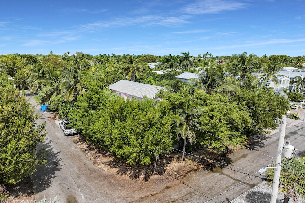
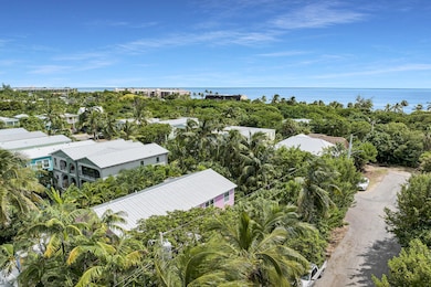
1301 Atlantic Dr Key West, FL 33040
Mid Town NeighborhoodEstimated payment $8,900/month
About This Home
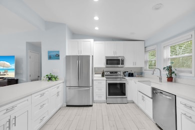
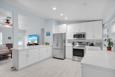
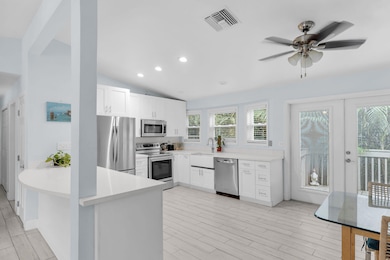
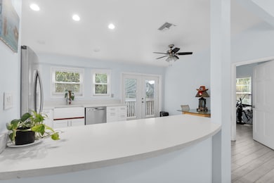
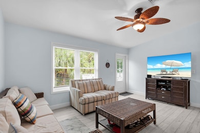
Rare Elevated Property in Key West. Located in a private cul de sac near the Casa Marina neighborhood. This is an excellent INVESTMENT OPPORTUNITY. This oversized 6,370 square foot, corner lot, is completely fenced in and private. Plenty of room for parking. 7 bedrooms and 5 bathrooms with 2,236 sq ft of living space. Detached and elevated 1 Bedroom and 1 Bathroom Legal Cottage. This property has potential for large family's and guests with endless entertaining possibility's. Plenty of rooms for office space and the storage space is unlimited. Also a contender for a lucrative short term vacation rental. Remodeled with impact windows and doors. Only a short walk to beaches, parks, restaurants and shopping. Hot tub for 12 people with heater and chiller. Room for a pool. You don't want to miss this opportunity. Call for your private showing today! SELLER FINANCING AVAILABLE
Map
Home Details
Home Type
Single Family
Year Built
1997
Lot Details
6,534 Sq Ft Lot
Listing Details
- Property Type: Residential
- Style: Single Family
- First Right of Refusal: No
- Mandatory HOA: No
- Fee Includes: None
- Key Island: Key West
- K W Neighborhood: Midtown West
- Limited Representation: No
- Marathon Neighborhood: N/A
- Mile Marker: 3.00
- Min Rental Days: 28.00
- M L S Identifier: 20060123165453488875000000
- Neighborhood Feature: Beach, Bike Paths
- Pets: Pets Allowed
- Property Group I D: 19990816212109142258000000
- Side: Ocean
- State Province: FL
- Taxes: 478.90
- Title: Title Ins - Seller
- Vehicle Storage: Carport, Off Street Parking
- Year Built: 1997
- Alternate Key Number: 1060330
- Cooling Heating: Central Air, Ceiling Fans(s)
- Lot Sq Ft: 6370.00
- Porch Balcony: Open Porch/Balcony, Deck
- Tax Exemptions: Homestead
- Building Style Above Flood: Unknown
- Estimated Living Sq Ft: 2236.00
- Property Condition: Updated/Remodeled
- Sewer Hook Up: Yes
- Statistical Purposes Only: No
- Special Features: None
- Property Sub Type: Detached
Interior Features
- Interior Amenities: Whirlpool Bath Tub
- Total Bathrooms: 5.00
- Full Bathrooms: 5
- Appliances: Washer, Stainless Steel Appliance(s), Microwave, Oven, Range, Refrigerator, Dishwasher, Dryer
- Floor: Tile
- Windows/Doors: Impact Rstnce Window, Impact Rstnce Doors
- Total Bedrooms: 7
Exterior Features
- Dockage: None
- Waterfront: None
- Waterfront: No
- Construction: Combo Construction
- Exterior Features: Fencing, Hot Tub, Detached Guest Qtrs, Fruit Tree(s)
- Roof: Metal Roof
- Waterview: No Waterview
- Pool: No
Utilities
- Utilities: FKAA
- Heating: Central
Lot Info
- Deed Restrictions: Unknown
- Flood Zone: AE
- Parcel Number: 00059870-000000
- Land Size: More than 1 Lot
- Acres: 0.15
Rental Info
- Rentals Allowed: With Restrictions
- Furnished: Negotiable
Tax Info
- Tax Year: 2024
Home Values in the Area
Average Home Value in this Area
Tax History
| Year | Tax Paid | Tax Assessment Tax Assessment Total Assessment is a certain percentage of the fair market value that is determined by local assessors to be the total taxable value of land and additions on the property. | Land | Improvement |
|---|---|---|---|---|
| 2025 | $479 | $710,012 | -- | -- |
| 2024 | $467 | $690,002 | -- | -- |
| 2023 | $467 | $669,905 | $0 | $0 |
| 2022 | $447 | $650,394 | $0 | $0 |
| 2021 | $428 | $631,451 | $0 | $0 |
| 2020 | $422 | $622,733 | $0 | $0 |
| 2019 | $418 | $608,733 | $0 | $0 |
| 2018 | $410 | $597,383 | $0 | $0 |
| 2017 | $410 | $585,096 | $0 | $0 |
| 2016 | $407 | $585,096 | $0 | $0 |
| 2015 | $420 | $504,427 | $0 | $0 |
| 2014 | $418 | $521,032 | $0 | $0 |
Property History
| Date | Event | Price | List to Sale | Price per Sq Ft |
|---|---|---|---|---|
| 03/01/2026 03/01/26 | Price Changed | $1,725,000 | -1.4% | $771 / Sq Ft |
| 02/01/2026 02/01/26 | Price Changed | $1,750,000 | -1.4% | $783 / Sq Ft |
| 11/12/2025 11/12/25 | Price Changed | $1,775,000 | -1.4% | $794 / Sq Ft |
| 10/04/2025 10/04/25 | For Sale | $1,800,000 | -- | $805 / Sq Ft |
Purchase History
| Date | Type | Sale Price | Title Company |
|---|---|---|---|
| Trustee Deed | -- | None Available | |
| Warranty Deed | $100 | None Listed On Document | |
| Interfamily Deed Transfer | -- | Attorney | |
| Warranty Deed | -- | -- | |
| Quit Claim Deed | -- | -- | |
| Warranty Deed | -- | -- |
Source: Key West Association of REALTORS®
MLS Number: 616733
APN: 00059870-000000
Disclaimer: Certain information contained herein is derived from information provided by parties other than Homes.com. All information provided is deemed reliable, but is not guaranteed to be accurate and should be independently verified.
![]() IDX information is provided exclusively for personal, non-commercial use, and may not be used for any purpose other than to identify prospective properties consumers may be interested in purchasing. Information is deemed reliable but not guaranteed.
IDX information is provided exclusively for personal, non-commercial use, and may not be used for any purpose other than to identify prospective properties consumers may be interested in purchasing. Information is deemed reliable but not guaranteed.
- 1310 Atlantic Dr
- 1626 Sirugo Ave
- 1313 Atlantic Dr
- 1328 Laird St
- 1501 Georgia St
- 1314 Johnson St
- 1217 Johnson St
- 1519 Johnson St
- 1224 Flagler Ave
- 1101 Casa Marina Ct
- 1501 White St
- 1501 Florida St
- 1422 Patricia St
- 1501 Laird St
- 1505 Rose St
- 1503 Johnson St
- 1420 White St
- 1505 Johnson St
- 1416 White St
- 1500 Atlantic Blvd Unit 311
- 1318 Duncan St Unit 3
- 1417 Ashby St Unit 3
- 927 Catherine St
- 1916 Staples Ave
- 1116 Truman Ave Unit 1
- 2026 Seidenberg Ave Unit SI ID1297830P
- 1330 3rd St
- 2005 Fogarty Ave
- 2214 Seidenberg Ave
- 14 Hilton Haven Rd
- 629 Elizabeth St Unit SI ID1297833P
- 2513 Staples Ave Unit B
- 717 Southard St
- 2623 Flagler Ave Unit SI ID1307035P
- 536 Fleming St Unit SI FL2-ID1297611P
- 750 Fort St
- 120 Angela St Unit SI ID1384034P
- 3312 Northside Dr Unit 316
- 800 Sigsbee Rd
- 3655 Seaside Dr Unit 326

Ask me questions while you tour the home.