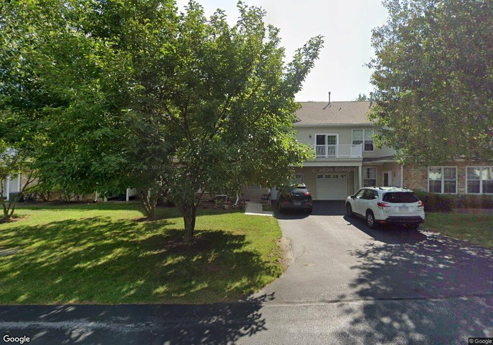
1304 Nicklaus Dr Unit P135 Springfield, PA 19064
Estimated Value: $420,000 - $503,615
2
Beds
2
Baths
1,419
Sq Ft
$325/Sq Ft
Est. Value
About This Home
This home is located at 1304 Nicklaus Dr Unit P135, Springfield, PA 19064 and is currently estimated at $461,808, approximately $325 per square foot. 1304 Nicklaus Dr Unit P135 is a home located in Delaware County with nearby schools including Springfield High School, St Francis Of Assisi School, and Notre Dame De Lourdes Catholic School.
Ownership History
Date
Name
Owned For
Owner Type
Purchase Details
Closed on
Jul 27, 2023
Sold by
Brophy Dolores
Bought by
Brophy Irrevocable Family Trust and Brophy
Current Estimated Value
Purchase Details
Closed on
Jan 15, 2003
Sold by
Nelson Lillian A
Bought by
Brophy William and Brophy Dolores
Home Financials for this Owner
Home Financials are based on the most recent Mortgage that was taken out on this home.
Original Mortgage
$164,000
Interest Rate
6.18%
Mortgage Type
Purchase Money Mortgage
Purchase Details
Closed on
Apr 19, 2000
Sold by
Golf View Venture Lp
Bought by
Nelson Lillian A
Home Financials for this Owner
Home Financials are based on the most recent Mortgage that was taken out on this home.
Original Mortgage
$50,000
Interest Rate
7.62%
Create a Home Valuation Report for This Property
The Home Valuation Report is an in-depth analysis detailing your home's value as well as a comparison with similar homes in the area
Home Values in the Area
Average Home Value in this Area
Purchase History
| Date | Buyer | Sale Price | Title Company |
|---|---|---|---|
| Brophy Irrevocable Family Trust | -- | None Listed On Document | |
| Brophy William | $205,000 | Fidelity Natl Title Ins Co O | |
| Nelson Lillian A | $146,900 | -- |
Source: Public Records
Mortgage History
| Date | Status | Borrower | Loan Amount |
|---|---|---|---|
| Previous Owner | Brophy William | $164,000 | |
| Previous Owner | Nelson Lillian A | $50,000 |
Source: Public Records
Tax History Compared to Growth
Tax History
| Year | Tax Paid | Tax Assessment Tax Assessment Total Assessment is a certain percentage of the fair market value that is determined by local assessors to be the total taxable value of land and additions on the property. | Land | Improvement |
|---|---|---|---|---|
| 2025 | $7,176 | $255,300 | $79,750 | $175,550 |
| 2024 | $7,176 | $255,300 | $79,750 | $175,550 |
| 2023 | $6,968 | $255,300 | $79,750 | $175,550 |
| 2022 | $6,760 | $255,300 | $79,750 | $175,550 |
| 2021 | $10,275 | $255,300 | $79,750 | $175,550 |
| 2020 | $6,172 | $0 | $0 | $0 |
| 2019 | $6,172 | $0 | $0 | $0 |
| 2018 | $6,172 | $141,500 | $0 | $0 |
| 2017 | $0 | $141,500 | $0 | $0 |
| 2016 | $0 | $141,500 | $0 | $0 |
| 2015 | -- | $141,500 | $0 | $0 |
| 2014 | -- | $141,500 | $0 | $0 |
Source: Public Records
Map
Nearby Homes
- 1366 Nicklaus Dr Unit O125
- 651 N Chester Rd
- 519 Walnut Ln Unit 1
- 364 S Rolling Rd
- 341 Kennerly Rd
- 457 Kennerly Rd
- 719 Pine Ridge Rd
- 838 Springhaven Rd
- 326 Powell Rd
- 1008 Lincoln Ave
- 773 Beatty View Rd
- 603 Beatty Rd
- 517 W Woodland Ave
- 444 Kerr Ln
- 251 Powell Rd
- 411 Marie Dr
- 945 Springhaven Rd
- 268 Beechwood Rd
- 232 S Highland Rd
- 224 Ballymore Rd
- 1305 Palmer Dr
- 1302 Nicklaus Dr Unit P136
- 1306 Nicklaus Dr Unit P134
- 1309 Palmer Dr Unit P128
- 1307 Palmer Dr Unit P129
- 1303 Palmer Dr Unit P131
- 1308 Nicklaus Dr Unit P133
- 1361 Palmer Dr Unit O123
- 1329 Nicklaus Dr Unit R146
- 1301 Palmer Dr Unit P132
- 1431 Country Club Dr
- 1321 Nicklaus Dr Unit R142
- 1323 Nicklaus Dr Unit R143
- 1363 Palmer Dr Unit O122
- 1424 Palmer Dr Unit M107
- 1299 Country Club Dr Unit Q141
- 1433 Country Club Dr Unit T214
- 1325 Nicklaus Dr Unit R144
- 1367 Palmer Dr Unit O120
- 1369 Palmer Dr Unit O119