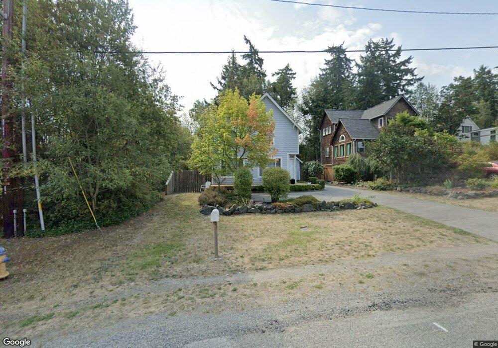
1305 14th St Port Townsend, WA 98368
Estimated Value: $488,000 - $612,000
2
Beds
2
Baths
1,392
Sq Ft
$394/Sq Ft
Est. Value
About This Home
This home is located at 1305 14th St, Port Townsend, WA 98368 and is currently estimated at $548,147, approximately $393 per square foot. 1305 14th St is a home located in Jefferson County with nearby schools including Salish Coast Elementary School, Blue Heron Middle School, and Port Townsend High School.
Ownership History
Date
Name
Owned For
Owner Type
Purchase Details
Closed on
Jan 6, 2021
Sold by
Schmidt Sarah A
Bought by
Kennedy Michael and Kennedy Andrea
Current Estimated Value
Home Financials for this Owner
Home Financials are based on the most recent Mortgage that was taken out on this home.
Original Mortgage
$352,818
Outstanding Balance
$314,836
Interest Rate
2.7%
Mortgage Type
New Conventional
Estimated Equity
$233,311
Purchase Details
Closed on
Jan 18, 2006
Sold by
Villers Doug
Bought by
Schmidt Walt and Schmidt Sarah A
Create a Home Valuation Report for This Property
The Home Valuation Report is an in-depth analysis detailing your home's value as well as a comparison with similar homes in the area
Home Values in the Area
Average Home Value in this Area
Purchase History
| Date | Buyer | Sale Price | Title Company |
|---|---|---|---|
| Kennedy Michael | $365,000 | Jefferson Title Co Inc | |
| Schmidt Walt | $275,000 | None Available |
Source: Public Records
Mortgage History
| Date | Status | Borrower | Loan Amount |
|---|---|---|---|
| Open | Kennedy Michael | $352,818 |
Source: Public Records
Tax History Compared to Growth
Tax History
| Year | Tax Paid | Tax Assessment Tax Assessment Total Assessment is a certain percentage of the fair market value that is determined by local assessors to be the total taxable value of land and additions on the property. | Land | Improvement |
|---|---|---|---|---|
| 2024 | $3,657 | $431,404 | $126,000 | $305,404 |
| 2023 | $3,657 | $407,126 | $115,000 | $292,126 |
| 2022 | $3,405 | $392,126 | $100,000 | $292,126 |
| 2021 | $3,152 | $350,769 | $81,250 | $269,519 |
| 2020 | $2,975 | $313,138 | $71,500 | $241,638 |
| 2019 | $2,528 | $288,050 | $65,000 | $223,050 |
| 2018 | $2,766 | $265,964 | $52,800 | $213,164 |
| 2017 | $2,373 | $254,358 | $48,300 | $206,058 |
| 2016 | $2,003 | $233,042 | $48,300 | $184,742 |
| 2015 | $1,947 | $204,620 | $48,300 | $156,320 |
| 2014 | -- | $197,514 | $48,300 | $149,214 |
| 2013 | -- | $188,110 | $46,000 | $142,110 |
Source: Public Records
Map
Nearby Homes
- 2997 Hancock St
- 1030 11th St
- 0 13th St Unit NWM2458063
- 10 NKA Wilson St
- 0 Sherman St
- 999 Jackman St
- 2012 Queen Anne Place
- 1 xxxx Thomas St
- 1011 Thomas St
- 545 Hendricks St Unit 13
- 545 Hendricks St Unit 10A
- 480 State Route 20
- 1525 Grant St
- 652 Mcpherson St
- 2257 W Rosecrans Ct
- 2117 Renee Place
- 2289 Towne Point Ave
- 5679 Sheridan St
- 15 Xx7 Rainier St
- 15 xx Rainier St