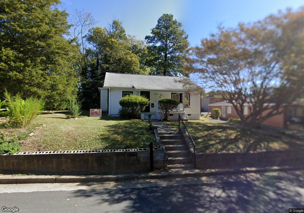
1308 Daniels Ave Anderson, SC 29625
Estimated Value: $71,045 - $223,000
--
Bed
--
Bath
1,298
Sq Ft
$114/Sq Ft
Est. Value
About This Home
This home is located at 1308 Daniels Ave, Anderson, SC 29625 and is currently estimated at $148,511, approximately $114 per square foot. 1308 Daniels Ave is a home located in Anderson County with nearby schools including Concord Elementary School, McCants Middle School, and T.L. Hanna High School.
Ownership History
Date
Name
Owned For
Owner Type
Purchase Details
Closed on
Jan 31, 2025
Sold by
Moss Ida and Moss Andre
Bought by
Moss Andre Lamont and Moss Bryll Kilpatrick
Current Estimated Value
Home Financials for this Owner
Home Financials are based on the most recent Mortgage that was taken out on this home.
Original Mortgage
$76,312
Outstanding Balance
$75,260
Interest Rate
6.93%
Mortgage Type
FHA
Estimated Equity
$73,251
Purchase Details
Closed on
Nov 16, 2020
Sold by
Sims Harriett
Bought by
Moss Ida
Create a Home Valuation Report for This Property
The Home Valuation Report is an in-depth analysis detailing your home's value as well as a comparison with similar homes in the area
Home Values in the Area
Average Home Value in this Area
Purchase History
| Date | Buyer | Sale Price | Title Company |
|---|---|---|---|
| Moss Andre Lamont | -- | First Source Title Agency Inc | |
| Moss Andre Lamont | -- | First Source Title Agency Inc | |
| Moss Ida | -- | None Available |
Source: Public Records
Mortgage History
| Date | Status | Borrower | Loan Amount |
|---|---|---|---|
| Open | Moss Andre Lamont | $76,312 | |
| Closed | Moss Andre Lamont | $76,312 |
Source: Public Records
Tax History Compared to Growth
Tax History
| Year | Tax Paid | Tax Assessment Tax Assessment Total Assessment is a certain percentage of the fair market value that is determined by local assessors to be the total taxable value of land and additions on the property. | Land | Improvement |
|---|---|---|---|---|
| 2024 | $40 | $1,570 | $200 | $1,370 |
| 2023 | $40 | $1,570 | $200 | $1,370 |
| 2022 | $40 | $1,570 | $200 | $1,370 |
| 2021 | $372 | $2,150 | $210 | $1,940 |
| 2020 | $187 | $1,430 | $140 | $1,290 |
| 2019 | $187 | $1,430 | $140 | $1,290 |
| 2018 | $189 | $1,430 | $140 | $1,290 |
| 2017 | -- | $1,430 | $140 | $1,290 |
| 2016 | $174 | $1,520 | $140 | $1,380 |
| 2015 | $176 | $1,520 | $140 | $1,380 |
| 2014 | $176 | $1,520 | $140 | $1,380 |
Source: Public Records
Map
Nearby Homes
- 211 Cater St
- 208 Cater St
- 1014 Tribble St
- 504 Piedmont Ave
- 1008 Tribble St
- 1212 W End Ave
- 1105 W End Ave
- 607 Piedmont Ave
- 220 Moultrie Square
- 406 Moultrie Square
- 401 Berkshire Hill
- 1808 Edgewood Ave
- 0 High Shoals Rd
- 705 E Mauldin St
- 1710 Martin Ave
- 228 Santorini Way
- 338 F St
- 507 Blair St
- 710 W Mauldin St
- 1721 Martin Ave