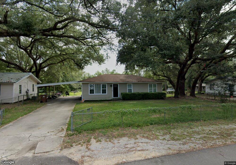
13080 Michael St Biloxi, MS 39532
Estimated Value: $109,907 - $213,000
3
Beds
--
Bath
1,350
Sq Ft
$114/Sq Ft
Est. Value
About This Home
This home is located at 13080 Michael St, Biloxi, MS 39532 and is currently estimated at $153,977, approximately $114 per square foot. 13080 Michael St is a home located in Harrison County with nearby schools including Woolmarket Elementary School, North Woolmarket Elementary/Middle School, and D'Iberville Senior High School.
Ownership History
Date
Name
Owned For
Owner Type
Purchase Details
Closed on
May 8, 2020
Sold by
Tiblier Blaine J and Tibler Elizabeth D
Bought by
Gonsoulin Scott and Gonsoulin Tina
Current Estimated Value
Home Financials for this Owner
Home Financials are based on the most recent Mortgage that was taken out on this home.
Original Mortgage
$72,350
Outstanding Balance
$64,214
Interest Rate
3.5%
Mortgage Type
New Conventional
Estimated Equity
$89,763
Create a Home Valuation Report for This Property
The Home Valuation Report is an in-depth analysis detailing your home's value as well as a comparison with similar homes in the area
Home Values in the Area
Average Home Value in this Area
Purchase History
| Date | Buyer | Sale Price | Title Company |
|---|---|---|---|
| Gonsoulin Scott | -- | None Available |
Source: Public Records
Mortgage History
| Date | Status | Borrower | Loan Amount |
|---|---|---|---|
| Open | Gonsoulin Scott | $72,350 |
Source: Public Records
Tax History
| Year | Tax Paid | Tax Assessment Tax Assessment Total Assessment is a certain percentage of the fair market value that is determined by local assessors to be the total taxable value of land and additions on the property. | Land | Improvement |
|---|---|---|---|---|
| 2025 | $1,001 | $8,687 | $0 | $0 |
| 2024 | $948 | $8,239 | $0 | $0 |
| 2023 | $953 | $8,239 | $0 | $0 |
| 2022 | $959 | $8,239 | $0 | $0 |
| 2021 | $962 | $8,239 | $0 | $0 |
| 2020 | $880 | $7,288 | $0 | $0 |
| 2019 | $886 | $7,288 | $0 | $0 |
| 2018 | $894 | $7,299 | $0 | $0 |
| 2017 | $398 | $4,867 | $0 | $0 |
| 2015 | $438 | $5,207 | $0 | $0 |
| 2014 | -- | $3,685 | $0 | $0 |
| 2013 | -- | $5,207 | $1,522 | $3,685 |
Source: Public Records
Map
Nearby Homes
- 0 Airport Rd
- 8505 Poplar Trail
- 9092 Woolmarket Rd
- 14177 Quill Ave
- 0 Woolmarket Rd
- 00 Lorraine Rd
- 7970 Buttonbush Rd
- 7978 Bottombush Rd
- 7964 Buttonbush Rd
- 12999 Shriners Blvd
- 9213 Selena Dr
- 0 Boss Husley Rd
- 12330 Oaklawn Rd
- 9257 Natures Trail
- 9356 Goldfinch Ct
- 12204 Evelyn Ave
- 0 Hillside Rd
- 13627 Mayberry Ct
- 13624 Mayberry Ct
- 13633 Mayberry Ct
- 13084 Michael St
- 13072 Michael St
- 13079 Michael St
- 13090 Michael St
- 13075 Michael St
- 13067 Michael St
- 13055 Michael St
- 13098 Michael St
- 13046 Michael St
- 13099 Michael St
- 13050 Marvin St
- 13108 Michael St
- 13078 Marvin St
- 13042 Marvin St
- 13107 Michael St
- 13037 Michael St
- 13088 Marvin St
- 13072 Marvin St
- 8395 Louise St
- 13026 Marvin St
Your Personal Tour Guide
Ask me questions while you tour the home.