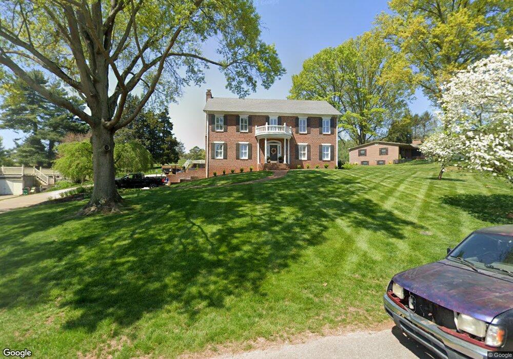
1309 Bales Dr Morristown, TN 37814
Estimated Value: $580,641 - $638,000
--
Bed
4
Baths
3,697
Sq Ft
$165/Sq Ft
Est. Value
About This Home
This home is located at 1309 Bales Dr, Morristown, TN 37814 and is currently estimated at $610,910, approximately $165 per square foot. 1309 Bales Dr is a home located in Hamblen County with nearby schools including West Elementary School, Lincoln Heights Middle School, and Morristown West High School.
Ownership History
Date
Name
Owned For
Owner Type
Purchase Details
Closed on
Sep 2, 2022
Sold by
Zierer William A
Bought by
Lynch Paul Adam and Lynch Ashlee Poole
Current Estimated Value
Purchase Details
Closed on
Feb 11, 2008
Sold by
Zierer Sharlene
Bought by
Zierer William A
Purchase Details
Closed on
Feb 5, 2003
Sold by
Gurley Dennis E
Bought by
Zierer William A
Home Financials for this Owner
Home Financials are based on the most recent Mortgage that was taken out on this home.
Original Mortgage
$145,000
Interest Rate
5.89%
Purchase Details
Closed on
Aug 20, 1985
Bought by
Gurley Dennis E and Pamela Jordan
Create a Home Valuation Report for This Property
The Home Valuation Report is an in-depth analysis detailing your home's value as well as a comparison with similar homes in the area
Home Values in the Area
Average Home Value in this Area
Purchase History
| Date | Buyer | Sale Price | Title Company |
|---|---|---|---|
| Lynch Paul Adam | $535,000 | -- | |
| Zierer William A | -- | -- | |
| Zierer William A | $325,000 | -- | |
| Gurley Dennis E | -- | -- |
Source: Public Records
Mortgage History
| Date | Status | Borrower | Loan Amount |
|---|---|---|---|
| Previous Owner | Gurley Dennis E | $145,000 |
Source: Public Records
Tax History Compared to Growth
Tax History
| Year | Tax Paid | Tax Assessment Tax Assessment Total Assessment is a certain percentage of the fair market value that is determined by local assessors to be the total taxable value of land and additions on the property. | Land | Improvement |
|---|---|---|---|---|
| 2024 | $1,630 | $92,600 | $10,600 | $82,000 |
| 2023 | $1,630 | $92,600 | $0 | $0 |
| 2022 | $2,926 | $92,600 | $10,600 | $82,000 |
| 2021 | $2,926 | $92,600 | $10,600 | $82,000 |
| 2020 | $2,923 | $92,600 | $10,600 | $82,000 |
| 2019 | $2,738 | $80,525 | $10,250 | $70,275 |
| 2018 | $2,537 | $80,525 | $10,250 | $70,275 |
| 2017 | $2,496 | $80,525 | $10,250 | $70,275 |
| 2016 | $2,383 | $80,525 | $10,250 | $70,275 |
| 2015 | $2,218 | $80,525 | $10,250 | $70,275 |
| 2014 | -- | $80,525 | $10,250 | $70,275 |
| 2013 | -- | $91,200 | $0 | $0 |
Source: Public Records
Map
Nearby Homes
- 1033 Walters Dr
- 1626 Cardinal Dr
- 1613 Cardinal Dr
- 941 Heykoop Dr
- 2020 N Economy Rd
- 2045 N Economy Rd Unit A3
- 707 Walters Dr
- 1230 Mcfarland St Unit 37
- 1230 Mcfarland St Unit 3
- 1442 Darbee Dr
- 1361 Appalachian Trace
- 1318 Secretariat Dr
- 2310 Sandstone Dr
- Lot 267 Waterview Way
- Lot 289 Inlet Cove
- Lot 295 Inlet Cove
- 2454 Sandstone Dr
- 2444 Sandstone Dr
- 2430 Sandstone Dr
- 1303 Bales Dr
- 1313 Bales Dr
- 1317 Bales Dr
- 1299 Bales Dr
- 1306 Bales Dr
- 1316 Bales Dr
- 1300 Bales Dr
- 1314 Bales Dr
- 1415 Bales Dr
- 1415 Bales Dr
- 1318 Bales Dr
- 1307 Walters Dr
- 1311 Walters Dr
- 1239 Walters Dr
- 1415 Whiteside Dr
- 1233 Walters Dr
- 1425 Whiteside Dr
- 1225 Walters Dr
- 1318 Walters Dr
- 1310 Walters Dr