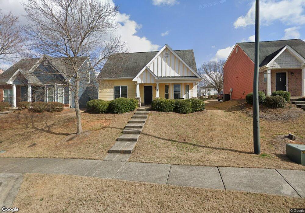
131 Katydid Dr Athens, GA 30601
North Avenue NeighborhoodEstimated Value: $305,203 - $327,000
3
Beds
3
Baths
1,309
Sq Ft
$242/Sq Ft
Est. Value
About This Home
This home is located at 131 Katydid Dr, Athens, GA 30601 and is currently estimated at $317,301, approximately $242 per square foot. 131 Katydid Dr is a home located in Clarke County with nearby schools including Howard B. Stroud Elementary School, Coile Middle School, and Cedar Shoals High School.
Ownership History
Date
Name
Owned For
Owner Type
Purchase Details
Closed on
Jan 14, 2020
Sold by
Salisbury Alley Llc
Bought by
Salisbury Alley Llc and Salisbnury Wood Llc
Current Estimated Value
Purchase Details
Closed on
Oct 16, 2007
Sold by
Not Provided
Bought by
Shim Diane
Home Financials for this Owner
Home Financials are based on the most recent Mortgage that was taken out on this home.
Original Mortgage
$99,020
Interest Rate
6.27%
Mortgage Type
New Conventional
Purchase Details
Closed on
May 10, 2006
Sold by
Not Provided
Bought by
Shim Diane
Create a Home Valuation Report for This Property
The Home Valuation Report is an in-depth analysis detailing your home's value as well as a comparison with similar homes in the area
Home Values in the Area
Average Home Value in this Area
Purchase History
| Date | Buyer | Sale Price | Title Company |
|---|---|---|---|
| Salisbury Alley Llc | -- | -- | |
| Shim Diane | $124,400 | -- | |
| Shim Diane | $40,000 | -- |
Source: Public Records
Mortgage History
| Date | Status | Borrower | Loan Amount |
|---|---|---|---|
| Previous Owner | Shim Diane | $99,020 |
Source: Public Records
Tax History
| Year | Tax Paid | Tax Assessment Tax Assessment Total Assessment is a certain percentage of the fair market value that is determined by local assessors to be the total taxable value of land and additions on the property. | Land | Improvement |
|---|---|---|---|---|
| 2025 | $3,627 | $116,811 | $12,000 | $104,811 |
| 2024 | $3,627 | $112,880 | $12,000 | $100,880 |
| 2023 | $3,528 | $103,039 | $10,400 | $92,639 |
| 2022 | $2,739 | $85,858 | $10,400 | $75,458 |
| 2021 | $2,115 | $62,760 | $9,600 | $53,160 |
| 2020 | $2,019 | $59,898 | $9,600 | $50,298 |
| 2019 | $1,945 | $57,284 | $9,600 | $47,684 |
| 2018 | $1,851 | $54,511 | $9,600 | $44,911 |
| 2017 | $1,678 | $49,438 | $9,600 | $39,838 |
| 2016 | $1,617 | $47,623 | $9,600 | $38,023 |
| 2015 | $1,620 | $47,637 | $9,600 | $38,037 |
| 2014 | $1,506 | $44,236 | $9,600 | $34,636 |
Source: Public Records
Map
Nearby Homes
- 190 Conrad Dr
- 455 Ruth St
- 464 Ruth St
- 211 North Ave Unit 1225
- 211 North Ave
- 211 North Ave Unit 1227
- 118 Ruth Dr Unit 610
- 118 Ruth Dr Unit 130
- 118 Ruth Dr Unit 140
- 118 Ruth Dr Unit 310
- 495 Boley Dr
- 239 Madison Heights
- 192 Sunny Hills Dr
- 390 Athens Ave
- 249 Fifth St
- 668 Pulaski St
- 447 Rosa Nell Howard St
- 860 College Ave
- 940 College Ave
- 600 Pulaski St
- 141 Katydid Dr
- 121 Katydid Dr
- 151 Katydid Dr
- 111 Katydid Dr
- 420 Bridgewater Way
- 161 Katydid Dr
- 101 Katydid Dr
- 118 Katydid Dr
- 430 Bridgewater Way
- 124 Katydid Dr
- 112 Katydid Dr
- 106 Katydid Dr
- 130 Katydid Dr
- 440 Bridgewater Way
- 171 Katydid Dr
- 136 Katydid Dr
- 100 Katydid Dr
- 450 Bridgewater Way
- 142 Katydid Dr
- 119 Fern Ridge Ct
Your Personal Tour Guide
Ask me questions while you tour the home.