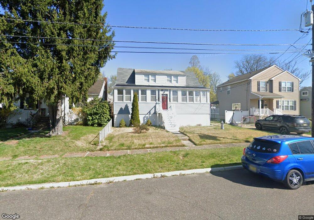
131 W Broadway Maple Shade, NJ 08052
Estimated Value: $263,000 - $332,000
--
Bed
--
Bath
1,415
Sq Ft
$220/Sq Ft
Est. Value
About This Home
This home is located at 131 W Broadway, Maple Shade, NJ 08052 and is currently estimated at $310,853, approximately $219 per square foot. 131 W Broadway is a home located in Burlington County with nearby schools including Ralph J Steinhauer Elementary School, Maude M. Wilkins Elementary School, and Howard R Yocum School.
Ownership History
Date
Name
Owned For
Owner Type
Purchase Details
Closed on
Feb 4, 2012
Sold by
Rappo Jeanette D
Bought by
Rappo John B
Current Estimated Value
Create a Home Valuation Report for This Property
The Home Valuation Report is an in-depth analysis detailing your home's value as well as a comparison with similar homes in the area
Home Values in the Area
Average Home Value in this Area
Purchase History
| Date | Buyer | Sale Price | Title Company |
|---|---|---|---|
| Rappo John B | -- | None Available |
Source: Public Records
Tax History Compared to Growth
Tax History
| Year | Tax Paid | Tax Assessment Tax Assessment Total Assessment is a certain percentage of the fair market value that is determined by local assessors to be the total taxable value of land and additions on the property. | Land | Improvement |
|---|---|---|---|---|
| 2025 | $6,028 | $158,800 | $41,900 | $116,900 |
| 2024 | $5,853 | $158,800 | $41,900 | $116,900 |
| 2023 | $5,853 | $158,800 | $41,900 | $116,900 |
| 2022 | $5,763 | $158,800 | $41,900 | $116,900 |
| 2021 | $5,707 | $158,800 | $41,900 | $116,900 |
| 2020 | $5,723 | $158,800 | $41,900 | $116,900 |
| 2019 | $5,514 | $158,800 | $41,900 | $116,900 |
| 2018 | $5,418 | $158,800 | $41,900 | $116,900 |
| 2017 | $5,355 | $158,800 | $41,900 | $116,900 |
| 2016 | $5,275 | $158,800 | $41,900 | $116,900 |
| 2015 | $5,161 | $158,800 | $41,900 | $116,900 |
| 2014 | $5,004 | $158,800 | $41,900 | $116,900 |
Source: Public Records
Map
Nearby Homes
- 48 N Terrace Ave
- 301 N Coles Ave
- 29 W Broadway
- 480 W Front St
- 432 N Coles Ave
- 524 W Main St
- 22 Theodore Ave
- 57 S Terrace Ave
- 19 Farnsworth Ave
- 4 W Germantown Ave
- 15 N Poplar Ave
- 505 Greenwood Ave
- 12 Collins Ln
- 107 S Forklanding Rd
- 104 E Laurelton Ave
- 32 Woodbine Ave
- 5 Paul Rd
- 112 S Maple Ave
- 8515 Bryn Mawr Ave
- 218 E Germantown Ave
- 135 W Broadway
- 125 W Broadway
- 121 W Broadway
- 109 N Coles Ave
- 103 N Coles Ave
- 130 W Linwood Ave
- 117 W Broadway
- 134 W Linwood Ave
- 126 W Linwood Ave
- 138 W Linwood Ave
- 122 W Linwood Ave
- 113 W Broadway
- 140 W Linwood Ave
- 114 W Linwood Ave
- 109 W Broadway
- 110 W Linwood Ave
- 56 N Clinton Ave
- 108 N Coles Ave
- 105 W Broadway
- 55 N Coles Ave