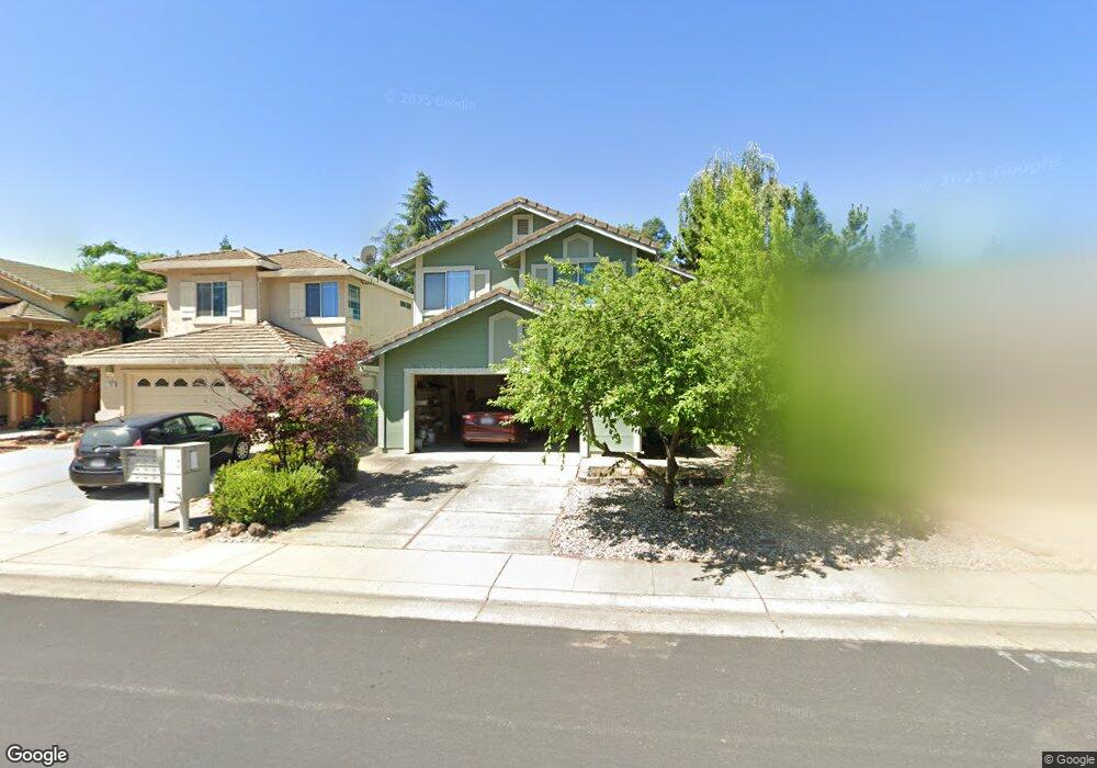
131 Whiting Way Folsom, CA 95630
Estimated Value: $636,149 - $691,000
4
Beds
3
Baths
1,858
Sq Ft
$360/Sq Ft
Est. Value
About This Home
This home is located at 131 Whiting Way, Folsom, CA 95630 and is currently estimated at $668,037, approximately $359 per square foot. 131 Whiting Way is a home located in Sacramento County with nearby schools including Theodore Judah Elementary School, Sutter Middle School, and Folsom High School.
Ownership History
Date
Name
Owned For
Owner Type
Purchase Details
Closed on
Dec 18, 2015
Sold by
Lake Joann R and The Joann R Lake Trust
Bought by
Lake Joann R and The Joann R Lake Trust
Current Estimated Value
Home Financials for this Owner
Home Financials are based on the most recent Mortgage that was taken out on this home.
Original Mortgage
$123,000
Outstanding Balance
$97,563
Interest Rate
3.96%
Mortgage Type
New Conventional
Estimated Equity
$570,474
Purchase Details
Closed on
May 3, 2004
Sold by
Lake Stanley A
Bought by
Lake Joann R and The Joann R Lake Trust
Purchase Details
Closed on
Nov 13, 2001
Sold by
Engelhart Cindy A
Bought by
Lake Stanley A
Home Financials for this Owner
Home Financials are based on the most recent Mortgage that was taken out on this home.
Original Mortgage
$160,000
Interest Rate
6.62%
Purchase Details
Closed on
Sep 16, 1998
Sold by
Sieber Wormald Douglas Michael and Sieber Kristen
Bought by
Engelhart Cindy A
Home Financials for this Owner
Home Financials are based on the most recent Mortgage that was taken out on this home.
Original Mortgage
$130,000
Interest Rate
6.88%
Purchase Details
Closed on
Sep 11, 1998
Sold by
Engelhat Bret A
Bought by
Engelhart Cindy A
Home Financials for this Owner
Home Financials are based on the most recent Mortgage that was taken out on this home.
Original Mortgage
$130,000
Interest Rate
6.88%
Purchase Details
Closed on
Mar 6, 1996
Sold by
Wormald Douglas Michael and Wormald Kristen
Bought by
Wormald Douglas M and Wormald Kristen
Home Financials for this Owner
Home Financials are based on the most recent Mortgage that was taken out on this home.
Original Mortgage
$157,000
Interest Rate
7.01%
Purchase Details
Closed on
Aug 18, 1994
Sold by
Ken Inc
Bought by
Wormald Douglas Michael and Siebert Kristen
Home Financials for this Owner
Home Financials are based on the most recent Mortgage that was taken out on this home.
Original Mortgage
$154,840
Interest Rate
8.8%
Create a Home Valuation Report for This Property
The Home Valuation Report is an in-depth analysis detailing your home's value as well as a comparison with similar homes in the area
Purchase History
| Date | Buyer | Sale Price | Title Company |
|---|---|---|---|
| Lake Joann R | -- | First American Title Company | |
| Lake Joann R | -- | -- | |
| Lake Stanley A | $252,000 | First American Title Ins Co | |
| Lake Stanley A | -- | First American Title Ins Co | |
| Engelhart Cindy A | $177,500 | Old Republic Title Company | |
| Engelhart Cindy A | -- | Old Republic Title Company | |
| Wormald Douglas M | -- | -- | |
| Wormald Douglas Michael | $163,000 | Placer Title Company |
Source: Public Records
Mortgage History
| Date | Status | Borrower | Loan Amount |
|---|---|---|---|
| Open | Lake Joann R | $123,000 | |
| Closed | Lake Stanley A | $160,000 | |
| Previous Owner | Engelhart Cindy A | $130,000 | |
| Previous Owner | Wormald Douglas M | $157,000 | |
| Previous Owner | Wormald Douglas Michael | $154,840 |
Source: Public Records
Tax History
| Year | Tax Paid | Tax Assessment Tax Assessment Total Assessment is a certain percentage of the fair market value that is determined by local assessors to be the total taxable value of land and additions on the property. | Land | Improvement |
|---|---|---|---|---|
| 2025 | $4,097 | $372,278 | $88,625 | $283,653 |
| 2024 | $4,014 | $364,980 | $86,888 | $278,092 |
| 2023 | $3,943 | $357,825 | $85,185 | $272,640 |
| 2022 | $3,886 | $350,810 | $83,515 | $267,295 |
| 2021 | $3,834 | $343,932 | $81,878 | $262,054 |
| 2020 | $3,787 | $340,406 | $81,039 | $259,367 |
| 2019 | $3,725 | $333,732 | $79,450 | $254,282 |
| 2018 | $3,634 | $327,190 | $77,893 | $249,297 |
| 2017 | $3,395 | $320,775 | $76,366 | $244,409 |
| 2016 | $3,541 | $314,486 | $74,869 | $239,617 |
| 2015 | $3,424 | $309,763 | $73,745 | $236,018 |
| 2014 | $3,255 | $303,696 | $72,301 | $231,395 |
Source: Public Records
Map
Nearby Homes
- 118 Farham Dr
- 126 Larkin Cir
- 108 Austin Dr
- 701 Ferrier Way
- 692 Humbert St
- 1002 Sibley St Unit 25
- 451 Jewel Stone Way
- 447 Gem Smith Place
- 808 Orange Grove Way
- 683 Loomis Cir
- 735 King Way
- 756 Silo St
- 223 Price Way
- 784 Farmhouse Way
- 306 Dean Way
- 611 Mormon St
- 145 Timson Dr
- 219 Persifer St
- 900 Figueroa St Unit B
- 900 Figueroa St Unit E
- 133 Whiting Way
- 129 Whiting Way
- 135 Whiting Way
- 127 Whiting Way
- 116 Rockbolt Cir
- 118 Rockbolt Cir
- 119 Farham Dr
- 137 Whiting Way
- 125 Whiting Way
- 128 Larkin Cir
- 117 Farham Dr
- 118 Whiting Way
- 139 Whiting Way
- 120 Farham Dr
- 123 Whiting Way
- 130 Larkin Cir
- 114 Rockbolt Cir
- 116 Whiting Way
- 115 Farham Dr
- 141 Whiting Way
Your Personal Tour Guide
Ask me questions while you tour the home.