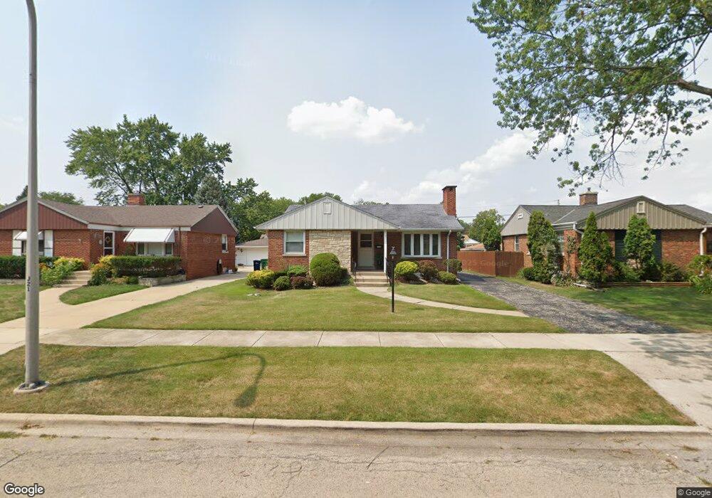
1310 Newcastle Ave Westchester, IL 60154
Estimated Value: $334,043 - $366,000
2
Beds
2
Baths
1,092
Sq Ft
$327/Sq Ft
Est. Value
About This Home
This home is located at 1310 Newcastle Ave, Westchester, IL 60154 and is currently estimated at $357,261, approximately $327 per square foot. 1310 Newcastle Ave is a home located in Cook County with nearby schools including Westchester Primary School, Westchester Intermediate School, and Westchester Middle School.
Ownership History
Date
Name
Owned For
Owner Type
Purchase Details
Closed on
Sep 25, 2009
Sold by
Pauksta Anne E
Bought by
Radney Janet A
Current Estimated Value
Home Financials for this Owner
Home Financials are based on the most recent Mortgage that was taken out on this home.
Original Mortgage
$230,743
Outstanding Balance
$151,209
Interest Rate
5.15%
Mortgage Type
FHA
Estimated Equity
$206,052
Purchase Details
Closed on
Jul 26, 2004
Sold by
Pauksta Leon and Pauksta Anne E
Bought by
Pauksta Anne E and Anne E Pauksta Living Trust
Create a Home Valuation Report for This Property
The Home Valuation Report is an in-depth analysis detailing your home's value as well as a comparison with similar homes in the area
Home Values in the Area
Average Home Value in this Area
Purchase History
| Date | Buyer | Sale Price | Title Company |
|---|---|---|---|
| Radney Janet A | $235,000 | Premier Title | |
| Pauksta Anne E | -- | Chicago Title Insurance Comp |
Source: Public Records
Mortgage History
| Date | Status | Borrower | Loan Amount |
|---|---|---|---|
| Open | Radney Janet A | $230,743 |
Source: Public Records
Tax History Compared to Growth
Tax History
| Year | Tax Paid | Tax Assessment Tax Assessment Total Assessment is a certain percentage of the fair market value that is determined by local assessors to be the total taxable value of land and additions on the property. | Land | Improvement |
|---|---|---|---|---|
| 2024 | $4,732 | $24,001 | $5,121 | $18,880 |
| 2023 | $4,626 | $24,001 | $5,121 | $18,880 |
| 2022 | $4,626 | $21,321 | $4,389 | $16,932 |
| 2021 | $4,526 | $21,320 | $4,389 | $16,931 |
| 2020 | $4,540 | $21,320 | $4,389 | $16,931 |
| 2019 | $4,397 | $21,737 | $4,023 | $17,714 |
| 2018 | $4,336 | $21,737 | $4,023 | $17,714 |
| 2017 | $5,021 | $21,737 | $4,023 | $17,714 |
| 2016 | $4,537 | $18,055 | $3,657 | $14,398 |
| 2015 | $4,443 | $18,055 | $3,657 | $14,398 |
| 2014 | $4,356 | $18,055 | $3,657 | $14,398 |
| 2013 | $4,607 | $20,957 | $3,657 | $17,300 |
Source: Public Records
Map
Nearby Homes
- 10072 Drury Ln
- 1119 Newcastle Ave
- 1247 S Mannheim Rd Unit 3
- 920 Suffolk Ave
- 1500 Bristol Ave
- 923 Manchester Ave
- 814 Norfolk Ave
- 805 Norfolk Ave
- 1623 Manchester Ave
- 1601 Bristol Ave
- 10524 Camelot St
- 723 Balmoral Ave
- 10531 Camelot St
- 750 Bristol Ave
- 1816 Manchester Ave
- 626 Manchester Ave
- 1907 Suffolk Ave
- 1900 Manchester Ave
- 1840 Gardner Rd
- 1932 Newcastle Ave
- 1306 Newcastle Ave
- 1316 Newcastle Ave
- 1322 Newcastle Ave
- 1300 Newcastle Ave
- 1309 Hull Ave
- 1315 Hull Ave
- 1307 Hull Ave
- 1326 Newcastle Ave
- 1321 Hull Ave
- 1301 Hull Ave
- 1327 Hull Ave
- 1330 Newcastle Ave
- 1311 Newcastle Ave
- 1317 Newcastle Ave
- 1307 Newcastle Ave
- 1323 Newcastle Ave
- 1331 Hull Ave
- 1301 Newcastle Ave
- 1336 Newcastle Ave
- 1327 Newcastle Ave