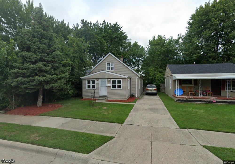
13105 Saint Andrews Ave Warren, MI 48089
Southeast Warren NeighborhoodEstimated Value: $103,865 - $129,000
--
Bed
2
Baths
837
Sq Ft
$134/Sq Ft
Est. Value
About This Home
This home is located at 13105 Saint Andrews Ave, Warren, MI 48089 and is currently estimated at $112,466, approximately $134 per square foot. 13105 Saint Andrews Ave is a home located in Macomb County with nearby schools including Lincoln Middle School, Lincoln High School, and Macomb Montessori Academy.
Ownership History
Date
Name
Owned For
Owner Type
Purchase Details
Closed on
Apr 16, 2021
Sold by
13105 St Andrews Llc
Bought by
Berkley Capital Investment Llc
Current Estimated Value
Purchase Details
Closed on
Nov 9, 2018
Sold by
Metropolitan Capital Management Llc
Bought by
13105 St Andrews Llc
Purchase Details
Closed on
Nov 15, 2013
Sold by
Robinson Reo Llc
Bought by
Metropolitan Capital Management Llc
Create a Home Valuation Report for This Property
The Home Valuation Report is an in-depth analysis detailing your home's value as well as a comparison with similar homes in the area
Home Values in the Area
Average Home Value in this Area
Purchase History
| Date | Buyer | Sale Price | Title Company |
|---|---|---|---|
| Berkley Capital Investment Llc | $52,550 | None Available | |
| 13105 St Andrews Llc | -- | None Available | |
| Metropolitan Capital Management Llc | $8,000 | Greco Title Agency Llc |
Source: Public Records
Tax History Compared to Growth
Tax History
| Year | Tax Paid | Tax Assessment Tax Assessment Total Assessment is a certain percentage of the fair market value that is determined by local assessors to be the total taxable value of land and additions on the property. | Land | Improvement |
|---|---|---|---|---|
| 2025 | $2,332 | $52,710 | $0 | $0 |
| 2024 | $2,283 | $47,720 | $0 | $0 |
| 2023 | $2,193 | $34,300 | $0 | $0 |
| 2022 | $2,149 | $29,480 | $0 | $0 |
| 2021 | $1,657 | $27,780 | $0 | $0 |
| 2020 | $1,620 | $23,370 | $0 | $0 |
| 2019 | $1,577 | $21,820 | $0 | $0 |
| 2018 | $1,217 | $23,810 | $0 | $0 |
| 2017 | $1,268 | $23,260 | $2,090 | $21,170 |
| 2016 | $1,258 | $23,260 | $0 | $0 |
| 2015 | -- | $24,600 | $0 | $0 |
| 2013 | $1,289 | $18,140 | $0 | $0 |
Source: Public Records
Map
Nearby Homes
- 22458 Hillock Ave
- 22513 Heussner Ave
- 13346 Fisk Ave
- 22803 Sharrow Ave
- 13304 Julius Ave
- 13425 Charlotte Ave
- 21855 Schoenherr Rd
- 13459 Toepfer Rd
- 12863 Couwlier Ave
- 12856 Couwlier Ave
- 13420 Couwlier Ave
- 13740 Leonard Ave
- 13742 Hobart Ave
- 12850 Sidonie Ave
- 13824 Hobart Ave
- 13403 Prospect Ave
- 13119 Sherman Ave
- 13876 Hendricks Ave
- 12777 Sherman Ave
- 13415 Sherman Ave
- 13113 Saint Andrews Ave
- 13121 Saint Andrews Ave
- 13055 Saint Andrews Ave
- 13121 St Andrews
- 13131 Saint Andrews Ave
- 13104 Fisk Ave
- 13112 Fisk Ave
- 13045 Saint Andrews Ave
- 13131 St Andrews Ave
- 13120 Fisk Ave
- 13141 Saint Andrews Ave
- 13130 Fisk Ave
- 13060 Fisk Ave
- 13104 Saint Andrews Ave
- 13112 Saint Andrews Ave
- 13035 Saint Andrews Ave
- 13120 Saint Andrews Ave
- 13140 Fisk Ave
- 13157 Saint Andrews Ave
- 13140 Saint Andrews Ave