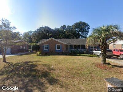
1311 Honeysuckle Ln Charleston, SC 29412
James Island NeighborhoodEstimated Value: $484,098 - $582,000
3
Beds
2
Baths
1,894
Sq Ft
$281/Sq Ft
Est. Value
About This Home
This home is located at 1311 Honeysuckle Ln, Charleston, SC 29412 and is currently estimated at $531,775, approximately $280 per square foot. 1311 Honeysuckle Ln is a home located in Charleston County with nearby schools including Harbor View Elementary School, Camp Road Middle, and James Island Charter High School.
Ownership History
Date
Name
Owned For
Owner Type
Purchase Details
Closed on
Oct 24, 2011
Sold by
Black Amos B and Bird Sarah E
Bought by
Cline Maxwell E
Current Estimated Value
Home Financials for this Owner
Home Financials are based on the most recent Mortgage that was taken out on this home.
Original Mortgage
$146,197
Interest Rate
3.75%
Mortgage Type
FHA
Purchase Details
Closed on
Feb 28, 2006
Sold by
Valentas Llc
Bought by
Black Amos B and Bird Sarah E
Purchase Details
Closed on
Sep 10, 2003
Sold by
Spivey Edward F and Spivey Leonora
Bought by
Valentine Richard T and Thomas Suneil
Create a Home Valuation Report for This Property
The Home Valuation Report is an in-depth analysis detailing your home's value as well as a comparison with similar homes in the area
Home Values in the Area
Average Home Value in this Area
Purchase History
| Date | Buyer | Sale Price | Title Company |
|---|---|---|---|
| Cline Maxwell E | $150,000 | -- | |
| Black Amos B | $223,500 | None Available | |
| Valentine Richard T | $143,500 | -- |
Source: Public Records
Mortgage History
| Date | Status | Borrower | Loan Amount |
|---|---|---|---|
| Open | Cline Maxwell E | $135,000 | |
| Closed | Cline Maxwell E | $146,197 |
Source: Public Records
Tax History Compared to Growth
Tax History
| Year | Tax Paid | Tax Assessment Tax Assessment Total Assessment is a certain percentage of the fair market value that is determined by local assessors to be the total taxable value of land and additions on the property. | Land | Improvement |
|---|---|---|---|---|
| 2023 | $1,119 | $8,680 | $0 | $0 |
| 2022 | $1,005 | $8,680 | $0 | $0 |
| 2021 | $1,072 | $8,680 | $0 | $0 |
| 2020 | $1,084 | $8,680 | $0 | $0 |
| 2019 | $993 | $7,540 | $0 | $0 |
| 2017 | $1,051 | $7,540 | $0 | $0 |
| 2016 | $1,010 | $7,540 | $0 | $0 |
| 2015 | $1,043 | $7,540 | $0 | $0 |
| 2014 | $881 | $0 | $0 | $0 |
| 2011 | -- | $0 | $0 | $0 |
Source: Public Records
Map
Nearby Homes
- 1114 Jeffery Dr
- 1402 Camp Rd Unit 8B
- 1402 Camp Rd Unit 10C
- 1174 Fort Johnson Rd
- 1418 Kentwood Cir
- 1404 Ivy Isle Dr
- 1172 Dawn Dr
- 1198 Oakcrest Dr
- 27 Brockman Dr Unit 27C
- 1224 Midvale Ave
- 1236 Midvale Ave
- 1135 Shoreham Rd
- 1534 Kentwood Cir
- 1239 Old Orchard Rd
- 20 Anderson Ave
- 1146 Rivercrest Dr
- 1117 Oceanview Rd
- 1125 Oceanview Rd
- 1089 Fort Johnson Rd
- 927 Dills Bluff Rd Unit G33
- 1311 Honeysuckle Ln
- 1315 Honeysuckle Ln
- 1307 Honeysuckle Ln
- 1312 Driftwood Dr
- 1308 Driftwood Dr
- 1316 Driftwood Dr
- 1305 Honeysuckle Ln
- 1312 Honeysuckle Ln
- 1321 Honeysuckle Ln
- 1308 Honeysuckle Ln
- 1316 Honeysuckle Ln
- 1304 Driftwood Dr
- 1060 Farmington Rd
- 1304 Honeysuckle Ln
- 1044 Farmington Rd
- 1267 Honeysuckle Ln
- 1268 Driftwood Dr
- 1268 Honeysuckle Ln
- 1311 Driftwood Dr
- 1311 Camp Rd