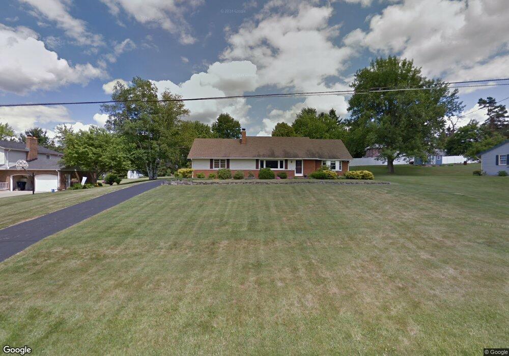
1311 Sandy Ln Mansfield, OH 44903
Estimated Value: $264,031 - $309,000
3
Beds
4
Baths
2,321
Sq Ft
$126/Sq Ft
Est. Value
About This Home
This home is located at 1311 Sandy Ln, Mansfield, OH 44903 and is currently estimated at $292,508, approximately $126 per square foot. 1311 Sandy Ln is a home located in Richland County with nearby schools including Madison High School, St. Peter's Elementary/Montessori School, and St. Peter's Junior High / High School.
Ownership History
Date
Name
Owned For
Owner Type
Purchase Details
Closed on
May 16, 2008
Sold by
Dix Thomas M and Dix Cheryl A
Bought by
Dix Thomas M and Dix Cheryl A
Current Estimated Value
Purchase Details
Closed on
May 12, 1994
Sold by
Abrams Gary L
Bought by
Dix Thomas M
Purchase Details
Closed on
Dec 17, 1990
Sold by
Reining Philip
Bought by
Abrams Gary L
Purchase Details
Closed on
Mar 1, 1986
Create a Home Valuation Report for This Property
The Home Valuation Report is an in-depth analysis detailing your home's value as well as a comparison with similar homes in the area
Home Values in the Area
Average Home Value in this Area
Purchase History
| Date | Buyer | Sale Price | Title Company |
|---|---|---|---|
| Dix Thomas M | -- | Attorney | |
| Dix Thomas M | $104,000 | -- | |
| Abrams Gary L | $85,000 | -- | |
| -- | $65,000 | -- |
Source: Public Records
Tax History
| Year | Tax Paid | Tax Assessment Tax Assessment Total Assessment is a certain percentage of the fair market value that is determined by local assessors to be the total taxable value of land and additions on the property. | Land | Improvement |
|---|---|---|---|---|
| 2024 | $2,381 | $65,830 | $8,030 | $57,800 |
| 2023 | $2,889 | $65,830 | $8,030 | $57,800 |
| 2022 | $2,535 | $51,560 | $7,490 | $44,070 |
| 2021 | $2,571 | $51,560 | $7,490 | $44,070 |
| 2020 | $2,423 | $51,560 | $7,490 | $44,070 |
| 2019 | $2,288 | $43,780 | $6,350 | $37,430 |
| 2018 | $2,744 | $52,990 | $6,350 | $46,640 |
| 2017 | $2,690 | $52,990 | $6,350 | $46,640 |
| 2016 | $2,858 | $54,730 | $6,160 | $48,570 |
| 2015 | $2,858 | $36,080 | $6,160 | $29,920 |
| 2014 | $1,771 | $36,080 | $6,160 | $29,920 |
| 2012 | $859 | $37,190 | $6,350 | $30,840 |
Source: Public Records
Map
Nearby Homes
- 1715 Mansfield Lucas Rd
- 0 Woodville Rd Unit Lot 14952, 14953
- 0 Woodville Rd Unit Lot 14954, 14955
- 0 Woodville Rd Unit Lot 14956, 14957,
- 2420 Mansfield Washington Rd
- 794 Mansfield Washington Rd
- 0 State Route 39 & I-71 Southeast Quadrant
- 0 State Route 39 & I-71 Northeast Quadrant
- 716 Mansfield Washington Rd
- 1599 S Main St
- 50 Lilac Ct E
- 1851 State Route 39
- 65 Logan Rd
- 537 Woodville Rd
- 33 Rambleside Dr
- 104 Elmridge Rd
- 1290 Bonnie Dr
- 430 Beethoven St
- 519 S Diamond St
- 2130 State Route 39
- 1405 Sandy Ln
- 1425 Sandy Ln
- 1354 Mansfield Washington Rd
- 1030 Freeway Cir
- 1441 Sandy Ln
- 1312 Washington North Rd
- 1312 Washington Rd N
- 1340 Washington North Rd
- 1272 Washington North Rd
- 1440 Sandy Ln
- 1455 Sandy Ln
- 1360 Mansfield Washington Rd
- 1350 Sandy Ln
- 1260 Washington North Rd
- 1313 Washington North Rd
- 1313 N Washington Rd
- 1260 Washington North Rd
- 1035 Freeway Cir
- 1311 Washington North Rd
- 1015 Freeway Cir
Your Personal Tour Guide
Ask me questions while you tour the home.